Date: 19/02/2019 12:14:37
From: mollwollfumble
ID: 1348527
Subject: Google Earth Images
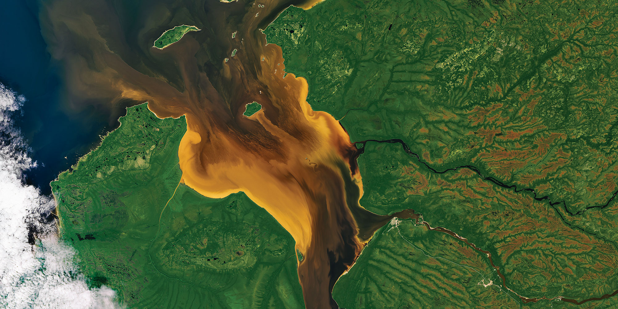
Post your favourite Google Earth images here.
Eg.
https://www.boredpanda.com/interesting-google-earth-map-finds/?afterlogin=savecommentvote&comment=3029696&score=-1
Date: 19/02/2019 13:12:11
From: Ian
ID: 1348554
Subject: re: Google Earth Images
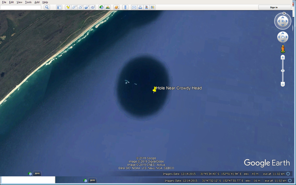
What is this hole off the NSW coast?
Date: 19/02/2019 13:16:09
From: Rule 303
ID: 1348555
Subject: re: Google Earth Images
Ian said:
What is this hole off the NSW coast?
The Earth is flat, remember. The hole is where the post at the centre of the turntable goes.
Date: 19/02/2019 13:26:38
From: Ian
ID: 1348557
Subject: re: Google Earth Images
Rule 303 said:
Ian said:
What is this hole off the NSW coast?
The Earth is flat, remember. The hole is where the post at the centre of the turntable goes.
:)
But the centre is at the north magnetic pole. Everyone knows that!
Date: 19/02/2019 13:27:22
From: party_pants
ID: 1348558
Subject: re: Google Earth Images
Ian said:
What is this hole off the NSW coast?
There’s an island, so it and a small patch of the surrounding ocean is displayed as photographed. The rest of the ocean is just coloured generically with some variation in colour for depth.
Date: 19/02/2019 13:42:58
From: Ian
ID: 1348559
Subject: re: Google Earth Images
party_pants said:
Ian said:
What is this hole off the NSW coast?
There’s an island, so it and a small patch of the surrounding ocean is displayed as photographed. The rest of the ocean is just coloured generically with some variation in colour for depth.
What island? Are you just making shit up?
Date: 19/02/2019 13:47:35
From: Michael V
ID: 1348562
Subject: re: Google Earth Images
Ian said:
What is this hole off the NSW coast?
I give up. You tell me.
Date: 19/02/2019 13:49:27
From: ChrispenEvan
ID: 1348565
Subject: re: Google Earth Images
Ian said:
party_pants said:
Ian said:
What is this hole off the NSW coast?
There’s an island, so it and a small patch of the surrounding ocean is displayed as photographed. The rest of the ocean is just coloured generically with some variation in colour for depth.
What island? Are you just making shit up?
they are exposed rocks. you can see the waves breaking on them.
Date: 19/02/2019 13:49:30
From: Ian
ID: 1348566
Subject: re: Google Earth Images
Michael V said:
Ian said:
What is this hole off the NSW coast?
I give up. You tell me.
Looks like a hole, a whole one.
Date: 19/02/2019 13:51:23
From: ChrispenEvan
ID: 1348567
Subject: re: Google Earth Images
ChrispenEvan said:
Ian said:
party_pants said:
There’s an island, so it and a small patch of the surrounding ocean is displayed as photographed. The rest of the ocean is just coloured generically with some variation in colour for depth.
What island? Are you just making shit up?
they are exposed rocks. you can see the waves breaking on them.
it is Mermaid Reef.
Date: 19/02/2019 13:52:04
From: Michael V
ID: 1348568
Subject: re: Google Earth Images
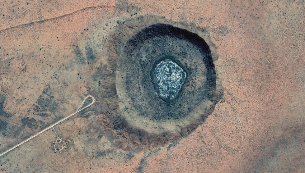
Wolfe Creek Meteorite Crater.
Date: 19/02/2019 13:52:30
From: furious
ID: 1348569
Subject: re: Google Earth Images
- What is this hole off the NSW coast?
It is the shadow of the satellite taking the picture…
yeah, I know that it is not…
Date: 19/02/2019 13:53:09
From: party_pants
ID: 1348570
Subject: re: Google Earth Images
Ian said:
party_pants said:
Ian said:
What is this hole off the NSW coast?
There’s an island, so it and a small patch of the surrounding ocean is displayed as photographed. The rest of the ocean is just coloured generically with some variation in colour for depth.
What island? Are you just making shit up?
rocks, islands, exposed tidal reefs, sandbars etc… a speck of land, I can see the waves breaking on.
Date: 19/02/2019 13:53:51
From: party_pants
ID: 1348571
Subject: re: Google Earth Images
Michael V said:
Wolfe Creek Meteorite Crater.
what’s that needle thing next to it?
:)
Date: 19/02/2019 13:54:07
From: Ian
ID: 1348572
Subject: re: Google Earth Images
ChrispenEvan said:
Ian said:
party_pants said:
There’s an island, so it and a small patch of the surrounding ocean is displayed as photographed. The rest of the ocean is just coloured generically with some variation in colour for depth.
What island? Are you just making shit up?
they are exposed rocks. you can see the waves breaking on them.
Ah ok.. optical trick… is it sinking down or sticking up?
Date: 19/02/2019 13:55:25
From: dv
ID: 1348573
Subject: re: Google Earth Images
Ian said:
Rule 303 said:
Ian said:
What is this hole off the NSW coast?
The Earth is flat, remember. The hole is where the post at the centre of the turntable goes.
:)
But the centre is at the north magnetic pole. Everyone knows that!
Fair to shake the very mandrels of the world
Date: 19/02/2019 14:00:24
From: Ian
ID: 1348574
Subject: re: Google Earth Images
dv said:
Ian said:
Rule 303 said:
The Earth is flat, remember. The hole is where the post at the centre of the turntable goes.
:)
But the centre is at the north magnetic pole. Everyone knows that!
Fair to shake the very mandrels of the world
mandrills
Date: 19/02/2019 14:03:23
From: Cymek
ID: 1348575
Subject: re: Google Earth Images
We check addresses for clients to make sure they are real and spelt correctly, etc often what’s recorded is wrong.
I remember checking one and the client was in Google street view with a police car out the front and him looking disheveled and angry
Date: 19/02/2019 14:05:03
From: furious
ID: 1348576
Subject: re: Google Earth Images
- We check addresses for clients
Is that what you have to call them? Clients?
Date: 19/02/2019 14:10:52
From: Cymek
ID: 1348578
Subject: re: Google Earth Images
furious said:
- We check addresses for clients
Is that what you have to call them? Clients?
Supposedly, offenders really
Date: 20/02/2019 13:15:46
From: mollwollfumble
ID: 1349004
Subject: re: Google Earth Images
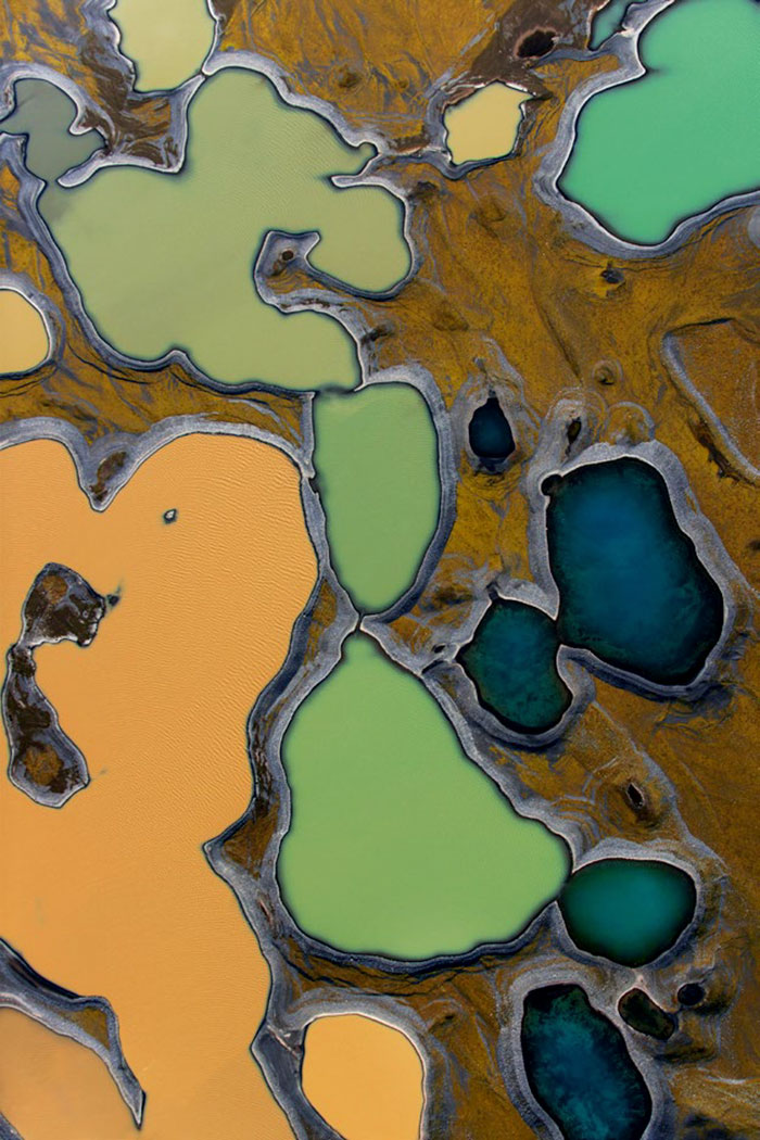
OK. Aerial photo, not Google Earth. Southern Iceland
Date: 20/02/2019 13:22:15
From: Ian
ID: 1349006
Subject: re: Google Earth Images
mollwollfumble said:
OK. Aerial photo, not Google Earth. Southern Iceland
Frozen lakes?
Date: 20/02/2019 13:24:43
From: mollwollfumble
ID: 1349008
Subject: re: Google Earth Images
Ian said:
mollwollfumble said:
OK. Aerial photo, not Google Earth. Southern Iceland
Frozen lakes?
I think so.
Date: 21/02/2019 19:14:29
From: sarahs mum
ID: 1349950
Subject: re: Google Earth Images

https://www.abc.net.au/news/2019-02-21/why-large-parts-of-earth-are-censored-by-google-maps/10826024
Date: 21/02/2019 19:26:56
From: mollwollfumble
ID: 1349961
Subject: re: Google Earth Images
sarahs mum said:
https://www.abc.net.au/news/2019-02-21/why-large-parts-of-earth-are-censored-by-google-maps/10826024
Got it. Image is of a “The MIM-104 Patriot is a surface-to-air missile system, the primary of its kind used by the United States Army and several allied nations.” In Taiwan.
Once looking at a Chinese Earthquake zone on Google Earth I stumbled across what looked like a giant Aeroplane in the Chinese mountains.
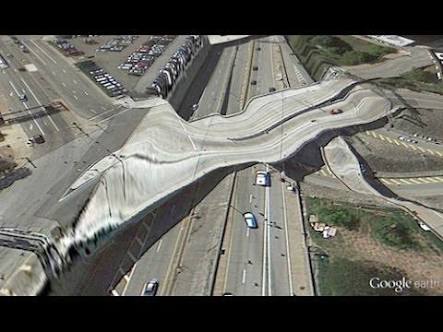
The whole vertical scale of Google Earth is badly out of whack anyway. So you couldn’t use it to direct missiles there anyway. And any adversary worth their salt is going to have better access to the original images.
Date: 21/02/2019 19:28:57
From: mollwollfumble
ID: 1349962
Subject: re: Google Earth Images
mollwollfumble said:
sarahs mum said:
https://www.abc.net.au/news/2019-02-21/why-large-parts-of-earth-are-censored-by-google-maps/10826024
Got it. Image is of a “The MIM-104 Patriot is a surface-to-air missile system, the primary of its kind used by the United States Army and several allied nations.” In Taiwan.
Once looking at a Chinese Earthquake zone on Google Earth I stumbled across what looked like a giant Aeroplane in the Chinese mountains.
The whole vertical scale of Google Earth is badly out of whack anyway. So you couldn’t use it to direct missiles there anyway. And any adversary worth their salt is going to have better access to the original images.
A typical example of how good the vertical heights are in Google Earth.
Date: 21/02/2019 19:29:33
From: OCDC
ID: 1349964
Subject: re: Google Earth Images
mollwollfumble said:
mollwollfumble said:sarahs mum said:
https://www.abc.net.au/news/2019-02-21/why-large-parts-of-earth-are-censored-by-google-maps/10826024
Got it. Image is of a “The MIM-104 Patriot is a surface-to-air missile system, the primary of its kind used by the United States Army and several allied nations.” In Taiwan.
Once looking at a Chinese Earthquake zone on Google Earth I stumbled across what looked like a giant Aeroplane in the Chinese mountains.
The whole vertical scale of Google Earth is badly out of whack anyway. So you couldn’t use it to direct missiles there anyway. And any adversary worth their salt is going to have better access to the original images.
A typical example of how good the vertical heights are in Google Earth.
Seems legit.
Date: 21/02/2019 19:30:10
From: Lary
ID: 1349967
Subject: re: Google Earth Images
mollwollfumble said:
I can’t see the issue….
Date: 21/02/2019 19:30:26
From: AwesomeO
ID: 1349969
Subject: re: Google Earth Images
mollwollfumble said:
sarahs mum said:
https://www.abc.net.au/news/2019-02-21/why-large-parts-of-earth-are-censored-by-google-maps/10826024
Got it. Image is of a “The MIM-104 Patriot is a surface-to-air missile system, the primary of its kind used by the United States Army and several allied nations.” In Taiwan.
Once looking at a Chinese Earthquake zone on Google Earth I stumbled across what looked like a giant Aeroplane in the Chinese mountains.
The whole vertical scale of Google Earth is badly out of whack anyway. So you couldn’t use it to direct missiles there anyway. And any adversary worth their salt is going to have better access to the original images.
Boy picky, back in the day you had to be satisfied with informed guesses and measuring shadows. Though I did hear one trick, minefields and barbed wire give themselves away as bands of different growth even when you cannot see them.
Date: 21/02/2019 19:31:18
From: Michael V
ID: 1349970
Subject: re: Google Earth Images
OCDC said:
mollwollfumble said:mollwollfumble said:Got it. Image is of a “The MIM-104 Patriot is a surface-to-air missile system, the primary of its kind used by the United States Army and several allied nations.” In Taiwan.
Once looking at a Chinese Earthquake zone on Google Earth I stumbled across what looked like a giant Aeroplane in the Chinese mountains.
The whole vertical scale of Google Earth is badly out of whack anyway. So you couldn’t use it to direct missiles there anyway. And any adversary worth their salt is going to have better access to the original images.
A typical example of how good the vertical heights are in Google Earth.
Seems legit.
If you’re peaking on LSD.
Date: 21/02/2019 19:32:30
From: AwesomeO
ID: 1349973
Subject: re: Google Earth Images
mollwollfumble said:
mollwollfumble said:
sarahs mum said:
https://www.abc.net.au/news/2019-02-21/why-large-parts-of-earth-are-censored-by-google-maps/10826024
Got it. Image is of a “The MIM-104 Patriot is a surface-to-air missile system, the primary of its kind used by the United States Army and several allied nations.” In Taiwan.
Once looking at a Chinese Earthquake zone on Google Earth I stumbled across what looked like a giant Aeroplane in the Chinese mountains.
The whole vertical scale of Google Earth is badly out of whack anyway. So you couldn’t use it to direct missiles there anyway. And any adversary worth their salt is going to have better access to the original images.
A typical example of how good the vertical heights are in Google Earth.
ahh, is that what does it. And gives birth to multiple websites called worlds craziest bridges etc.
Date: 21/02/2019 19:37:34
From: Tau.Neutrino
ID: 1349978
Subject: re: Google Earth Images
mollwollfumble said:
mollwollfumble said:
sarahs mum said:
https://www.abc.net.au/news/2019-02-21/why-large-parts-of-earth-are-censored-by-google-maps/10826024
Got it. Image is of a “The MIM-104 Patriot is a surface-to-air missile system, the primary of its kind used by the United States Army and several allied nations.” In Taiwan.
Once looking at a Chinese Earthquake zone on Google Earth I stumbled across what looked like a giant Aeroplane in the Chinese mountains.
The whole vertical scale of Google Earth is badly out of whack anyway. So you couldn’t use it to direct missiles there anyway. And any adversary worth their salt is going to have better access to the original images.
A typical example of how good the vertical heights are in Google Earth.
Salvador Dali Freeway Bridge
Date: 25/02/2019 23:02:48
From: mollwollfumble
ID: 1351957
Subject: re: Google Earth Images
NASA photoessay of the Earth as seen from space.
https://www.nasa.gov/connect/ebooks/earth_detail.html
Separate chapters for Atmosphere, Water, Land and Ice/Snow.
Eg.