Date: 20/02/2019 12:34:15
From: Ian
ID: 1348981
Subject: Tropical Cyclone Oma
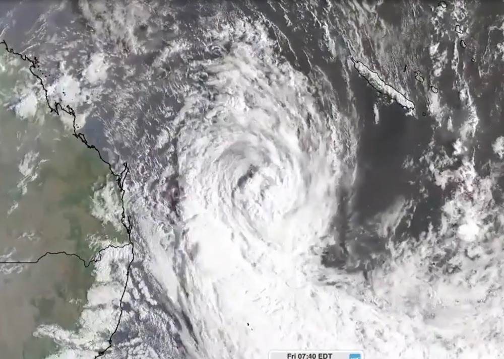
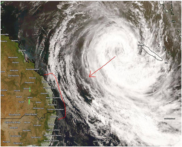
Severe Tropical Cyclone Oma could possibly cross the southern Queensland coast, after changing direction overnight, the Bureau of Meteorology (BOM) says.
The category three system is currently off New Caledonia, about 1,120 kilometres north-east of Brisbane.
BOM said it was no longer expected to turn south-east towards New Zealand over the weekend.
Forecaster Sam Campbell said instead the system was moving south-west.
He said a cyclone watch may be issued this afternoon ahead of gale force winds developing tomorrow.
“It’s now looking increasingly likely that it will continue on a westerly track towards the southern Queensland coast,” he said.
“Most likely it will weaken just a touch, it won’t be a category three by the time it gets to the coast, but just to emphasize that point we could actually see that cyclone coming into southern Queensland and possibly even a coastal crossing over the weekend.”
He said it was still unclear exactly where on the coast the system could reach.
http://www.weatherzone.com.au/news/tropical-cyclone-oma-could-cross-the-southern-queensland-coast-bom-says/529299
Date: 20/02/2019 12:38:56
From: Tamb
ID: 1348982
Subject: re: Tropical Cyclone Oma
Ian said:
Severe Tropical Cyclone Oma could possibly cross the southern Queensland coast, after changing direction overnight, the Bureau of Meteorology (BOM) says.
The category three system is currently off New Caledonia, about 1,120 kilometres north-east of Brisbane.
BOM said it was no longer expected to turn south-east towards New Zealand over the weekend.
Forecaster Sam Campbell said instead the system was moving south-west.
He said a cyclone watch may be issued this afternoon ahead of gale force winds developing tomorrow.
“It’s now looking increasingly likely that it will continue on a westerly track towards the southern Queensland coast,” he said.
“Most likely it will weaken just a touch, it won’t be a category three by the time it gets to the coast, but just to emphasize that point we could actually see that cyclone coming into southern Queensland and possibly even a coastal crossing over the weekend.”
He said it was still unclear exactly where on the coast the system could reach.
http://www.weatherzone.com.au/news/tropical-cyclone-oma-could-cross-the-southern-queensland-coast-bom-says/529299
Selfishly thinks. Oh goody, it’s going well south of me.
Date: 20/02/2019 12:44:31
From: party_pants
ID: 1348983
Subject: re: Tropical Cyclone Oma
Tamb said:
Ian said:
Severe Tropical Cyclone Oma could possibly cross the southern Queensland coast, after changing direction overnight, the Bureau of Meteorology (BOM) says.
The category three system is currently off New Caledonia, about 1,120 kilometres north-east of Brisbane.
BOM said it was no longer expected to turn south-east towards New Zealand over the weekend.
Forecaster Sam Campbell said instead the system was moving south-west.
He said a cyclone watch may be issued this afternoon ahead of gale force winds developing tomorrow.
“It’s now looking increasingly likely that it will continue on a westerly track towards the southern Queensland coast,” he said.
“Most likely it will weaken just a touch, it won’t be a category three by the time it gets to the coast, but just to emphasize that point we could actually see that cyclone coming into southern Queensland and possibly even a coastal crossing over the weekend.”
He said it was still unclear exactly where on the coast the system could reach.
http://www.weatherzone.com.au/news/tropical-cyclone-oma-could-cross-the-southern-queensland-coast-bom-says/529299
Selfishly thinks. Oh goody, it’s going well south of me.
don’t feel guilt over your own self-preservation :)
Date: 20/02/2019 12:47:45
From: Ian
ID: 1348984
Subject: re: Tropical Cyclone Oma
Selfishly thinks. Oh goody, it’s going well south of me.
—
Things are dying here for lack of water. I won’t say no to 150mm/day over the weekend.
Date: 20/02/2019 12:48:49
From: Tamb
ID: 1348985
Subject: re: Tropical Cyclone Oma
Ian said:
Selfishly thinks. Oh goody, it’s going well south of me.
—
Things are dying here for lack of water. I won’t say no to 150mm/day over the weekend.
We’ve had 190+ mm so far this month.
Date: 20/02/2019 12:50:59
From: Cymek
ID: 1348986
Subject: re: Tropical Cyclone Oma
The grandmother of all storms
Date: 20/02/2019 12:52:13
From: Peak Warming Man
ID: 1348988
Subject: re: Tropical Cyclone Oma
Ian said:
Selfishly thinks. Oh goody, it’s going well south of me.
—
Things are dying here for lack of water. I won’t say no to 150mm/day over the weekend.
Could be another false dawn, Ian.
I really hope not.
Date: 20/02/2019 12:57:45
From: Ian
ID: 1348991
Subject: re: Tropical Cyclone Oma
Peak Warming Man said:
Ian said:
Selfishly thinks. Oh goody, it’s going well south of me.
—
Things are dying here for lack of water. I won’t say no to 150mm/day over the weekend.
Could be another false dawn, Ian.
I really hope not.
Yeah well, it’s a cyclone. But even the BOM is now saying that the option for it to veer to NZ is looking very unlikely and talking about about that sort of rainfall.
Date: 20/02/2019 12:59:31
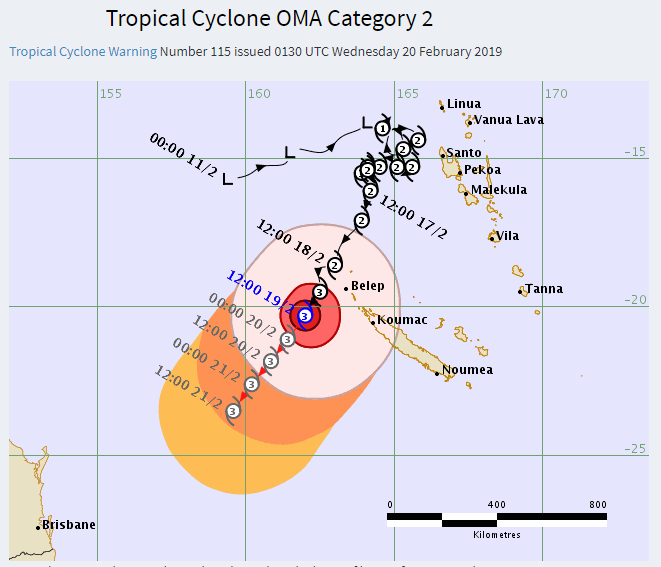
From: Michael V
ID: 1348992
Subject: re: Tropical Cyclone Oma
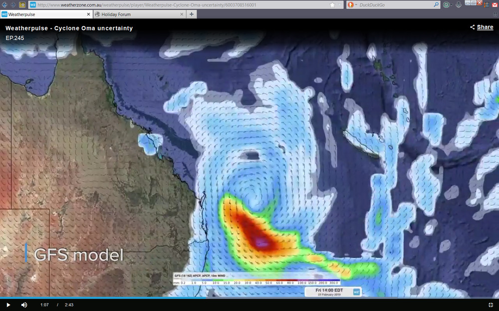
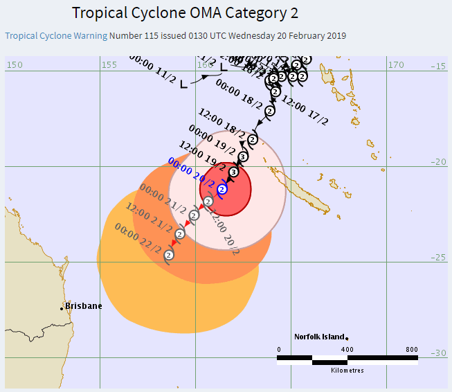
Current BoM Track Map:
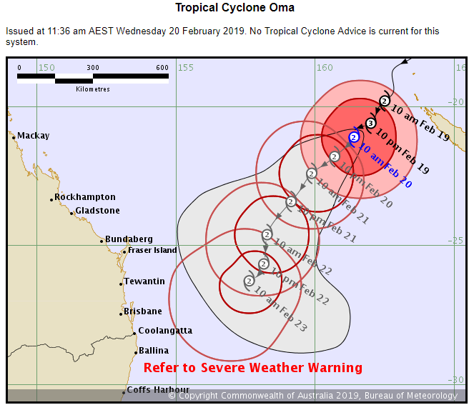
Current Fiji Meteorologic Service Track Map:
Date: 20/02/2019 12:59:44
From: Tamb
ID: 1348993
Subject: re: Tropical Cyclone Oma
Ian said:
Peak Warming Man said:
Ian said:
Selfishly thinks. Oh goody, it’s going well south of me.
—
Things are dying here for lack of water. I won’t say no to 150mm/day over the weekend.
Could be another false dawn, Ian.
I really hope not.
Yeah well, it’s a cyclone. But even the BOM is now saying that the option for it to veer to NZ is looking very unlikely and talking about about that sort of rainfall.
400mm possible falls on the Sunny coast.
Date: 20/02/2019 13:02:52
From: buffy
ID: 1348994
Subject: re: Tropical Cyclone Oma
Tamb said:
Ian said:
Selfishly thinks. Oh goody, it’s going well south of me.
—
Things are dying here for lack of water. I won’t say no to 150mm/day over the weekend.
We’ve had 190+ mm so far this month.
Hamilton has had 15mm. Had 1.4mm in January. But we get our rain in the Autumn and Spring breaks. Usually.
Date: 20/02/2019 13:03:23
From: Michael V
ID: 1348995
Subject: re: Tropical Cyclone Oma
Current BoM Interactive Weather and Wave Forecast Map:
Date: 20/02/2019 13:06:49
From: Tamb
ID: 1348998
Subject: re: Tropical Cyclone Oma
buffy said:
Tamb said:
Ian said:
Selfishly thinks. Oh goody, it’s going well south of me.
—
Things are dying here for lack of water. I won’t say no to 150mm/day over the weekend.
We’ve had 190+ mm so far this month.
Hamilton has had 15mm. Had 1.4mm in January. But we get our rain in the Autumn and Spring breaks. Usually.
February is normally our wettest month & September our driest.
Date: 20/02/2019 13:07:11
From: Ian
ID: 1348999
Subject: re: Tropical Cyclone Oma
Yeah well, it’s a cyclone. But even the BOM is now saying that the option for it to veer to NZ is looking very unlikely and talking about about that sort of rainfall.
__
Of course, if that amount of rainfall happens it will be a case of out drought and straight into flood…. again
Date: 20/02/2019 13:07:51
From: Michael V
ID: 1349000
Subject: re: Tropical Cyclone Oma
Michael V said:
Current BoM Interactive Weather and Wave Forecast Map:
And the Queensland regional version:
Date: 20/02/2019 13:10:31
From: sibeen
ID: 1349001
Subject: re: Tropical Cyclone Oma
Ian said:
Yeah well, it’s a cyclone. But even the BOM is now saying that the option for it to veer to NZ is looking very unlikely and talking about about that sort of rainfall.
__
Of course, if that amount of rainfall happens it will be a case of out drought and straight into flood…. again
Dorothea Mackellar would be so proud.
Date: 20/02/2019 13:13:18
From: party_pants
ID: 1349002
Subject: re: Tropical Cyclone Oma
Ian said:
Yeah well, it’s a cyclone. But even the BOM is now saying that the option for it to veer to NZ is looking very unlikely and talking about about that sort of rainfall.
__
Of course, if that amount of rainfall happens it will be a case of out drought and straight into flood…. again
It’s almost a normal thing now.
Date: 20/02/2019 13:14:49
From: Ian
ID: 1349003
Subject: re: Tropical Cyclone Oma
Michael V said:
Michael V said:
Current BoM Interactive Weather and Wave Forecast Map:
And the Queensland regional version:
You’re all over this thing Michael :)
Date: 20/02/2019 13:24:31
From: Michael V
ID: 1349007
Subject: re: Tropical Cyclone Oma
Ian said:
Michael V said:
Michael V said:
Current BoM Interactive Weather and Wave Forecast Map:
And the Queensland regional version:
You’re all over this thing Michael :)
Yeah, I’ve been following the low and the resulting cyclone since before the flooding rains started up north. I had an inkling that it may have formed a cyclone in the gulf. Instead, it made rain and lots of it. Now it’s a category 3 storm and been sucking much water in from the ocean, I’m watching it carefully. Basically to see whether I need to clean up my outside junk piles. And bring in chairs and tables etc. Tomorrow afternoon or Friday we’ll have a better idea, I reckon.
Perhaps a book on where it makes landfall (or not) should be run…
Date: 20/02/2019 13:26:01
From: buffy
ID: 1349010
Subject: re: Tropical Cyclone Oma
sibeen said:
Ian said:
Yeah well, it’s a cyclone. But even the BOM is now saying that the option for it to veer to NZ is looking very unlikely and talking about about that sort of rainfall.
__
Of course, if that amount of rainfall happens it will be a case of out drought and straight into flood…. again
Dorothea Mackellar would be so proud.
Oh dear, great minds and all that. Nothing is new, is it.
Date: 20/02/2019 13:29:28
From: mollwollfumble
ID: 1349013
Subject: re: Tropical Cyclone Oma
Still heading for New Zealand.

Date: 20/02/2019 13:36:23
From: Michael V
ID: 1349019
Subject: re: Tropical Cyclone Oma
mollwollfumble said:
Still heading for New Zealand.
Nearly 24 hours out of date, unfortunately. Cyclones move in all sorts of unpredictable ways. We’ll see what the next one brings.
Date: 20/02/2019 14:05:25
From: Ian
ID: 1349032
Subject: re: Tropical Cyclone Oma
Date: 20/02/2019 15:04:34
From: Divine Angel
ID: 1349053
Subject: re: Tropical Cyclone Oma
Cymek said:
The grandmother of all storms
Golf clap.
Date: 20/02/2019 15:09:00
From: Rule 303
ID: 1349055
Subject: re: Tropical Cyclone Oma
Divine Angel said:
Cymek said:
The grandmother of all storms
Golf clap.
You’ve heard of the Dutch Oven? Well this is the Dutch Cyclone.
God help us all…
:-)
Date: 20/02/2019 15:10:59
From: Divine Angel
ID: 1349058
Subject: re: Tropical Cyclone Oma
Rule 303 said:
Divine Angel said:
Cymek said:
The grandmother of all storms
Golf clap.
You’ve heard of the Dutch Oven? Well this is the Dutch Cyclone.
God help us all…
:-)
Ja, my mum is Dutch. She’s known as Oma to Mini Me. I’ve already told her to tell her cyclone to back off a bit.
Date: 20/02/2019 15:13:10
From: Divine Angel
ID: 1349060
Subject: re: Tropical Cyclone Oma
MV had better watch out.
https://www.brisbanetimes.com.au/national/queensland/tropical-cyclone-oma-now-category-3-changes-course-for-queensland-20190220-p50yxx.html
I have an emergency cyclone plan, just in case. I’ll head to my dad’s. I’m right near the bay but protected somewhat by Bribie and Moreton Islands. Wouldn’t expect any surge flooding but the winds would be a problem.
Date: 20/02/2019 15:18:07
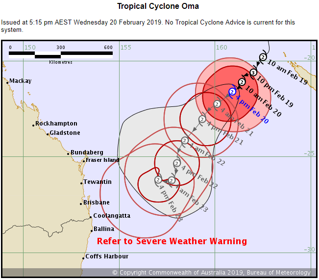
From: Michael V
ID: 1349063
Subject: re: Tropical Cyclone Oma
Michael V said:
mollwollfumble said:
Still heading for New Zealand.
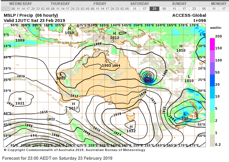
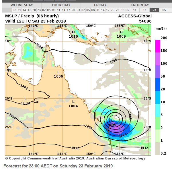
Nearly 24 hours out of date, unfortunately. Cyclones move in all sorts of unpredictable ways. We’ll see what the next one brings.
Here’s the next 4-day forecast (issued around 2pm on 20/2/19): Quite a difference, I’m sure you’ll agree.


Date: 20/02/2019 15:20:48
From: Divine Angel
ID: 1349065
Subject: re: Tropical Cyclone Oma
Apparently my ex lives on the GC now. It’s totally ok if Oma flattens his house.
Date: 20/02/2019 15:21:33
From: party_pants
ID: 1349066
Subject: re: Tropical Cyclone Oma
Divine Angel said:
Rule 303 said:
Divine Angel said:
Golf clap.
You’ve heard of the Dutch Oven? Well this is the Dutch Cyclone.
God help us all…
:-)
Ja, my mum is Dutch. She’s known as Oma to Mini Me. I’ve already told her to tell her cyclone to back off a bit.
Bit unfair on Oma to be blamed for something like this.
Date: 20/02/2019 15:23:18
From: Ian
ID: 1349069
Subject: re: Tropical Cyclone Oma
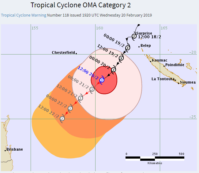
20-02-2019
Good morning everyone, Overnight Cyclone Oma has remained a category 3 system and overnight we have models in agreement now where there is a 80% chance of a coastal crossing however where Oma crosses will majorly depend on the effects you’ll feel.
As of this morning, we’re seeing model runs as well as the BOM’s official track map, We can see good evidence that there is a high chance of a coastal crossing around Hervey Bay. However we have multiple models playing around with the location of the crossing from as far north as Rockhampton and as far south as Coffs Harbor.
So today we are sitting at about an 80% yes for an imminent event, event type Cyclone. Cyclone Debbie weakened before she hit Brisbane and surrounds a few years ago but the flooding that she caused was devastating.
A lot of people are getting worried about Oma as she is the same system that cause major flooding in Townsville a few weeks ago but also is being compared to both Debbie and the 1954 floods. All I will say for now is prepare yourself for an event. Prepare your home and have a backup plan if the weather turns dangerous or life threatening. Be informed of any updates if you are in the proposed cyclone path and should the SES supply you with evacuation orders do follow procedure. It is quite possible at the moment for this to be the first cyclone in a very long time to hit SE QLD areas and IF this were to occur we could be looking at a historical event and the impact would be extreme in such a populated area.
As you can see we could be getting a lot of rain in a few days and the imminent part of this event is huge waves as well as abnormally high tides which will be exceeding the maximum yearly king tide level.
We will continue to keep you posted on Oma, NCSC is at about a 80% lock it in but we will wait until tonight or first thing tomorrow morning to make it an official happening.
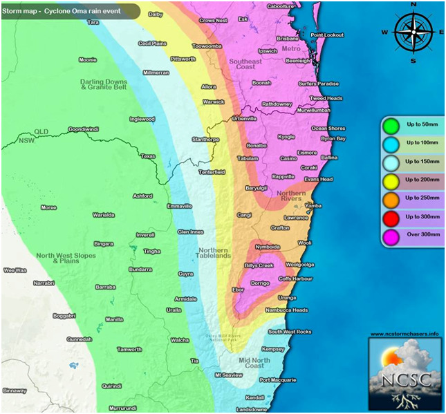
Now finally in image 4 we have our very own “Most Favoured” scenario based on all of the models and the consistency as of late. You can see that for NE
NSW and SE
QLD areas including the Sunshine Coast and further north that we have falls in excess of 300mm likely for major areas. This map is based purely on my own thoughts based on latest data and recent trends. The next two images are latest model predictions.. much higher.
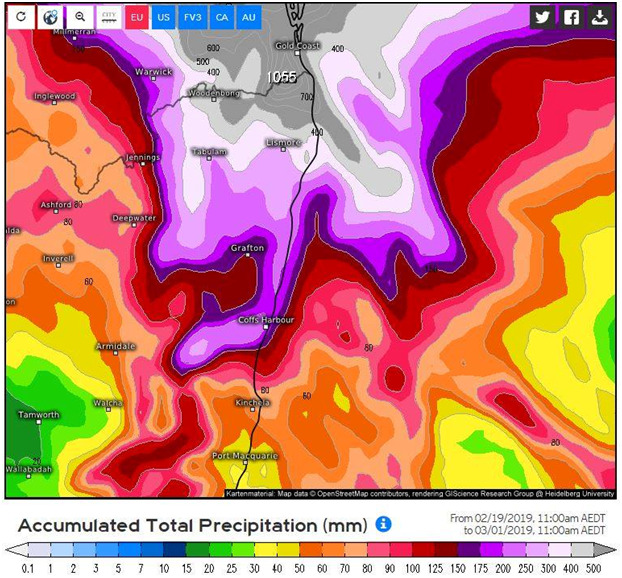
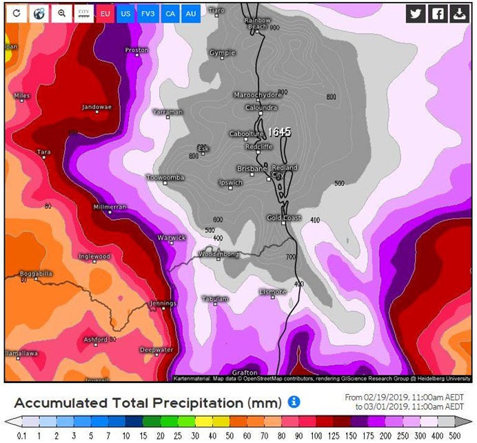
Images 5 & 6 are off the ECMWF models predictions for rainfall. Another reason i had made my own map was because as we can see with these two images attached showing NE NSW and SE QLD rainfall totals forecast by the time Oma comes onshore. We can see totals exceeding 500 – 800mm in the GREY shaded zones where some places go as high as 1100mm…
Now this is where I want to say not to stress because EC does like to overestimate rainfalls for events like this and as we get closer to the event those totals should start to go down a little. However it’s never that simple.. Very possibly we might actually see rainfall totals like this however the probability is much lower around 20 – 30% but the totals forecast in my Map are much more likely and…balanced. None the less we do need to keep an eye out as this forecast rainfall has been persistent for 3 days now and climbing.
North Coast Storm Chasers
(An amateur bloke but is usually way out in front of all the others for rain/storm events/TC Debbie)
Date: 20/02/2019 15:27:54
From: Michael V
ID: 1349072
Subject: re: Tropical Cyclone Oma
Divine Angel said:
MV had better watch out.
https://www.brisbanetimes.com.au/national/queensland/tropical-cyclone-oma-now-category-3-changes-course-for-queensland-20190220-p50yxx.html
I have an emergency cyclone plan, just in case. I’ll head to my dad’s. I’m right near the bay but protected somewhat by Bribie and Moreton Islands. Wouldn’t expect any surge flooding but the winds would be a problem.
Our emergency plan is simple.
*Tidy yard the day before.
*Expect the power to be off for a few days and therefore the water, too.
*We have headlamp torches and small LED stick-on lights.
*We have a truckload of batteries to power them.
*We’ll buy some 20 L bottles of water to tide us over.
*Feast on everything in the fridge and freezer.
*If the house gets blown away, we’ll make our way the the community centre.
*If it’s a bushfire that’s threatening, drive to the ocean and get in the water.
Date: 20/02/2019 15:29:17
From: Divine Angel
ID: 1349075
Subject: re: Tropical Cyclone Oma
Mr Mutant’s father lives in Hervey Bay. If the cyclone hits there, he’s in direct fire.
Date: 20/02/2019 15:36:55
From: Michael V
ID: 1349083
Subject: re: Tropical Cyclone Oma
Divine Angel said:
Mr Mutant’s father lives in Hervey Bay. If the cyclone hits there, he’s in direct fire.
Could be a fun weekend.
Date: 20/02/2019 15:45:38
From: Divine Angel
ID: 1349093
Subject: re: Tropical Cyclone Oma
Apparently Rainbow Beach is now on the NSW/Qld border.
https://www.news.com.au/technology/environment/potentially-destructive-cyclone-oma-could-hit-south-queensland-coast-this-weekend/news-story/0b440b1047702da78fa1d113041fab1a
Scroll down to the last photo.
Date: 20/02/2019 15:56:58
From: Michael V
ID: 1349101
Subject: re: Tropical Cyclone Oma
Divine Angel said:
Apparently Rainbow Beach is now on the NSW/Qld border.
https://www.news.com.au/technology/environment/potentially-destructive-cyclone-oma-could-hit-south-queensland-coast-this-weekend/news-story/0b440b1047702da78fa1d113041fab1a
Scroll down to the last photo.
Ha!
I heard they extracted the ute yesterday on low tide.
Date: 20/02/2019 16:37:28
From: Witty Rejoinder
ID: 1349109
Subject: re: Tropical Cyclone Oma
Ian said:
20-02-2019
Good morning everyone, Overnight Cyclone Oma has remained a category 3 system and overnight we have models in agreement now where there is a 80% chance of a coastal crossing however where Oma crosses will majorly depend on the effects you’ll feel.
As of this morning, we’re seeing model runs as well as the BOM’s official track map, We can see good evidence that there is a high chance of a coastal crossing around Hervey Bay. However we have multiple models playing around with the location of the crossing from as far north as Rockhampton and as far south as Coffs Harbor.
So today we are sitting at about an 80% yes for an imminent event, event type Cyclone. Cyclone Debbie weakened before she hit Brisbane and surrounds a few years ago but the flooding that she caused was devastating.
A lot of people are getting worried about Oma as she is the same system that cause major flooding in Townsville a few weeks ago but also is being compared to both Debbie and the 1954 floods. All I will say for now is prepare yourself for an event. Prepare your home and have a backup plan if the weather turns dangerous or life threatening. Be informed of any updates if you are in the proposed cyclone path and should the SES supply you with evacuation orders do follow procedure. It is quite possible at the moment for this to be the first cyclone in a very long time to hit SE QLD areas and IF this were to occur we could be looking at a historical event and the impact would be extreme in such a populated area.
As you can see we could be getting a lot of rain in a few days and the imminent part of this event is huge waves as well as abnormally high tides which will be exceeding the maximum yearly king tide level.
We will continue to keep you posted on Oma, NCSC is at about a 80% lock it in but we will wait until tonight or first thing tomorrow morning to make it an official happening.
Now finally in image 4 we have our very own “Most Favoured” scenario based on all of the models and the consistency as of late. You can see that for NE NSW and SE QLD areas including the Sunshine Coast and further north that we have falls in excess of 300mm likely for major areas. This map is based purely on my own thoughts based on latest data and recent trends. The next two images are latest model predictions.. much higher.
Images 5 & 6 are off the ECMWF models predictions for rainfall. Another reason i had made my own map was because as we can see with these two images attached showing NE NSW and SE QLD rainfall totals forecast by the time Oma comes onshore. We can see totals exceeding 500 – 800mm in the GREY shaded zones where some places go as high as 1100mm…
Now this is where I want to say not to stress because EC does like to overestimate rainfalls for events like this and as we get closer to the event those totals should start to go down a little. However it’s never that simple.. Very possibly we might actually see rainfall totals like this however the probability is much lower around 20 – 30% but the totals forecast in my Map are much more likely and…balanced. None the less we do need to keep an eye out as this forecast rainfall has been persistent for 3 days now and climbing.
North Coast Storm Chasers
(An amateur bloke but is usually way out in front of all the others for rain/storm events/TC Debbie)
Groovy… _regrets taking that LSD.
Date: 20/02/2019 17:16:04
From: Ian
ID: 1349121
Subject: re: Tropical Cyclone Oma
Witty Rejoinder said:
Ian said:
20-02-2019
Good morning everyone, Overnight Cyclone Oma has remained a category 3 system and overnight we have models in agreement now where there is a 80% chance of a coastal crossing however where Oma crosses will majorly depend on the effects you’ll feel.
As of this morning, we’re seeing model runs as well as the BOM’s official track map, We can see good evidence that there is a high chance of a coastal crossing around Hervey Bay. However we have multiple models playing around with the location of the crossing from as far north as Rockhampton and as far south as Coffs Harbor.
So today we are sitting at about an 80% yes for an imminent event, event type Cyclone. Cyclone Debbie weakened before she hit Brisbane and surrounds a few years ago but the flooding that she caused was devastating.
A lot of people are getting worried about Oma as she is the same system that cause major flooding in Townsville a few weeks ago but also is being compared to both Debbie and the 1954 floods. All I will say for now is prepare yourself for an event. Prepare your home and have a backup plan if the weather turns dangerous or life threatening. Be informed of any updates if you are in the proposed cyclone path and should the SES supply you with evacuation orders do follow procedure. It is quite possible at the moment for this to be the first cyclone in a very long time to hit SE QLD areas and IF this were to occur we could be looking at a historical event and the impact would be extreme in such a populated area.
As you can see we could be getting a lot of rain in a few days and the imminent part of this event is huge waves as well as abnormally high tides which will be exceeding the maximum yearly king tide level.
We will continue to keep you posted on Oma, NCSC is at about a 80% lock it in but we will wait until tonight or first thing tomorrow morning to make it an official happening.
Now finally in image 4 we have our very own “Most Favoured” scenario based on all of the models and the consistency as of late. You can see that for NE NSW and SE QLD areas including the Sunshine Coast and further north that we have falls in excess of 300mm likely for major areas. This map is based purely on my own thoughts based on latest data and recent trends. The next two images are latest model predictions.. much higher.
Images 5 & 6 are off the ECMWF models predictions for rainfall. Another reason i had made my own map was because as we can see with these two images attached showing NE NSW and SE QLD rainfall totals forecast by the time Oma comes onshore. We can see totals exceeding 500 – 800mm in the GREY shaded zones where some places go as high as 1100mm…
Now this is where I want to say not to stress because EC does like to overestimate rainfalls for events like this and as we get closer to the event those totals should start to go down a little. However it’s never that simple.. Very possibly we might actually see rainfall totals like this however the probability is much lower around 20 – 30% but the totals forecast in my Map are much more likely and…balanced. None the less we do need to keep an eye out as this forecast rainfall has been persistent for 3 days now and climbing.
North Coast Storm Chasers
(An amateur bloke but is usually way out in front of all the others for rain/storm events/TC Debbie)
Groovy… _regrets taking that LSD.
:)
I didn’t even post all the eyeball searing images I had.
Date: 20/02/2019 17:41:00
From: mollwollfumble
ID: 1349142
Subject: re: Tropical Cyclone Oma
Not ever the slightest hint of rain from it on the BOM radar so far.
Date: 20/02/2019 17:42:47
From: roughbarked
ID: 1349144
Subject: re: Tropical Cyclone Oma
mollwollfumble said:
Not ever the slightest hint of rain from it on the BOM radar so far.
It may not happen overnight ….
Date: 20/02/2019 18:30:35
From: Michael V
ID: 1349154
Subject: re: Tropical Cyclone Oma
Latest Fiji Meteorological Service Threat Map:
Latest BoM Forecast Track Map:
Date: 20/02/2019 18:43:36
From: Divine Angel
ID: 1349155
Subject: re: Tropical Cyclone Oma
I’m alert but not alarmed.
Date: 20/02/2019 18:49:34
From: OCDC
ID: 1349156
Subject: re: Tropical Cyclone Oma
I’ll be impressed when you get 1000 mm rain in 24 hours.
Date: 20/02/2019 18:57:00
From: Michael V
ID: 1349157
Subject: re: Tropical Cyclone Oma
OCDC said:
I’ll be impressed when you get 1000 mm rain in 24 hours.
How about 713 mm in 3 days (529 mm in 24 hours)?
August 23-25, 2007, Rainbow Beach.
Date: 20/02/2019 19:01:47
From: OCDC
ID: 1349166
Subject: re: Tropical Cyclone Oma
Michael V said:
OCDC said:I’ll be impressed when you get 1000 mm rain in 24 hours.
How about 713 mm in 3 days (529 mm in 24 hours)?
August 23-25, 2007, Rainbow Beach.
Nah. I’ve lived through more than that.
However I misremembered this event (it was smaller than I thought):
GC flood
Date: 20/02/2019 19:12:17
From: Michael V
ID: 1349173
Subject: re: Tropical Cyclone Oma
OCDC said:
Michael V said:OCDC said:I’ll be impressed when you get 1000 mm rain in 24 hours.
How about 713 mm in 3 days (529 mm in 24 hours)?
August 23-25, 2007, Rainbow Beach.
Nah. I’ve lived through more than that.
However I misremembered this event (it was smaller than I thought):
GC flood
:)
When I was working in Jamaica, we had over 140 inches (3.6 metres) of rain in 10 days. And there was three partly sunny days between the two hurricanes.
Date: 20/02/2019 19:15:50
From: mollwollfumble
ID: 1349182
Subject: re: Tropical Cyclone Oma
Michael V said:
OCDC said:
Michael V said:How about 713 mm in 3 days (529 mm in 24 hours)?
August 23-25, 2007, Rainbow Beach.
Nah. I’ve lived through more than that.
However I misremembered this event (it was smaller than I thought):
GC flood
:)
When I was working in Jamaica, we had over 140 inches (3.6 metres) of rain in 10 days. And there was three partly sunny days between the two hurricanes.
You were working bin Jamaica?
With the bauxite people there?
Date: 20/02/2019 19:27:18
From: Michael V
ID: 1349193
Subject: re: Tropical Cyclone Oma
mollwollfumble said:
Michael V said:
OCDC said:
Nah. I’ve lived through more than that.
However I misremembered this event (it was smaller than I thought):
GC flood
:)
When I was working in Jamaica, we had over 140 inches (3.6 metres) of rain in 10 days. And there was three partly sunny days between the two hurricanes.
You were working bin Jamaica?
With the bauxite people there?
No, a little gold mine.
IIRC, the bauxite mob was Kaiser. They were still going, but resource was running low.
Date: 20/02/2019 22:05:18
From: Divine Angel
ID: 1349391
Subject: re: Tropical Cyclone Oma
Just watched Higgins Storm Chasing’s video on Facebook. Of course, they don’t know for sure, however they’re predicting landfall at Fraser.
Hopefully by this time tomorrow, Oma will have made up her mind and decided what’s going on.
Date: 20/02/2019 22:07:29
From: roughbarked
ID: 1349396
Subject: re: Tropical Cyclone Oma
Divine Angel said:
Just watched Higgins Storm Chasing’s video on Facebook. Of course, they don’t know for sure, however they’re predicting landfall at Fraser.
Hopefully by this time tomorrow, Oma will have made up her mind and decided what’s going on.
The big high in the southern country will be what dctates terms.
Date: 20/02/2019 22:09:40
From: roughbarked
ID: 1349399
Subject: re: Tropical Cyclone Oma
roughbarked said:
Divine Angel said:
Just watched Higgins Storm Chasing’s video on Facebook. Of course, they don’t know for sure, however they’re predicting landfall at Fraser.
Hopefully by this time tomorrow, Oma will have made up her mind and decided what’s going on.
The big high in the southern country will be what dctates terms.
who could forget the i in dick?
Date: 20/02/2019 22:12:06
From: Michael V
ID: 1349401
Subject: re: Tropical Cyclone Oma
Divine Angel said:
Just watched Higgins Storm Chasing’s video on Facebook. Of course, they don’t know for sure, however they’re predicting landfall at Fraser.
Hopefully by this time tomorrow, Oma will have made up her mind and decided what’s going on.
:)
Date: 20/02/2019 22:14:19
From: roughbarked
ID: 1349402
Subject: re: Tropical Cyclone Oma
Michael V said:
Divine Angel said:
Just watched Higgins Storm Chasing’s video on Facebook. Of course, they don’t know for sure, however they’re predicting landfall at Fraser.
Hopefully by this time tomorrow, Oma will have made up her mind and decided what’s going on.
:)
https://tokyo3.org/forums/holiday/posts/1349399/
Date: 20/02/2019 22:17:21
From: Michael V
ID: 1349404
Subject: re: Tropical Cyclone Oma
The latest model from both the BoM and Windy.com has the storm approaching Fraser Island then going northwards, up, but somewhat off the coast. Our cumulative rainfall prediction has been revised down from 571.8 mm to 61-odd mm. Shows how difficult these big storms are to predict…
Date: 20/02/2019 22:17:37
From: roughbarked
ID: 1349405
Subject: re: Tropical Cyclone Oma
Divine Angel said:
Just watched Higgins Storm Chasing’s video on Facebook. Of course, they don’t know for sure, however they’re predicting landfall at Fraser.
Hopefully by this time tomorrow, Oma will have made up her mind and decided what’s going on.
Oz Cyclone Chasers haven’t bothered my email with a comment and yes, I don’t pay them for constant updates but I do get serious warnings.
Date: 20/02/2019 22:18:05
From: Michael V
ID: 1349407
Subject: re: Tropical Cyclone Oma
roughbarked said:
Michael V said:
Divine Angel said:
Just watched Higgins Storm Chasing’s video on Facebook. Of course, they don’t know for sure, however they’re predicting landfall at Fraser.
Hopefully by this time tomorrow, Oma will have made up her mind and decided what’s going on.
:)
https://tokyo3.org/forums/holiday/posts/1349399/
I saw that. No comment.
Date: 20/02/2019 22:18:54
From: Woodie
ID: 1349408
Subject: re: Tropical Cyclone Oma
Michael V said:
The latest model from both the BoM and Windy.com has the storm approaching Fraser Island then going northwards, up, but somewhat off the coast. Our cumulative rainfall prediction has been revised down from 571.8 mm to 61-odd mm. Shows how difficult these big storms are to predict…
So you’ve unpacked your bags, and cancelled you tickets to head for the hills?
Date: 20/02/2019 22:19:16
From: roughbarked
ID: 1349410
Subject: re: Tropical Cyclone Oma
Michael V said:
The latest model from both the BoM and Windy.com has the storm approaching Fraser Island then going northwards, up, but somewhat off the coast. Our cumulative rainfall prediction has been revised down from 571.8 mm to 61-odd mm. Shows how difficult these big storms are to predict…
Think cyclones and anticyclones. You have a cyclone in the northeast and an anticyclone in the southwest.
Date: 20/02/2019 22:20:57
From: Woodie
ID: 1349413
Subject: re: Tropical Cyclone Oma
Michael V said:
Divine Angel said:
Just watched Higgins Storm Chasing’s video on Facebook. Of course, they don’t know for sure, however they’re predicting landfall at Fraser.
Hopefully by this time tomorrow, Oma will have made up her mind and decided what’s going on.
:)
Having just look at likely tracking, I think our moolies may be revised down as well. Currently predictamed at:
WIll check again in the morning.
Date: 20/02/2019 22:21:17
From: Michael V
ID: 1349414
Subject: re: Tropical Cyclone Oma
Woodie said:
Michael V said:
The latest model from both the BoM and Windy.com has the storm approaching Fraser Island then going northwards, up, but somewhat off the coast. Our cumulative rainfall prediction has been revised down from 571.8 mm to 61-odd mm. Shows how difficult these big storms are to predict…
So you’ve unpacked your bags, and cancelled you tickets to head for the hills?
Nah. We were going to stay and have a fun experience.
Date: 20/02/2019 22:22:20
From: roughbarked
ID: 1349418
Subject: re: Tropical Cyclone Oma
Michael V said:
Woodie said:
Michael V said:
The latest model from both the BoM and Windy.com has the storm approaching Fraser Island then going northwards, up, but somewhat off the coast. Our cumulative rainfall prediction has been revised down from 571.8 mm to 61-odd mm. Shows how difficult these big storms are to predict…
So you’ve unpacked your bags, and cancelled you tickets to head for the hills?
Nah. We were going to stay and have a fun experience.
The high in the south is going to hold it there and overflow your rainwater storage.
Date: 20/02/2019 22:26:11
From: Michael V
ID: 1349426
Subject: re: Tropical Cyclone Oma
roughbarked said:
Michael V said:
Woodie said:
So you’ve unpacked your bags, and cancelled you tickets to head for the hills?
Nah. We were going to stay and have a fun experience.
The high in the south is going to hold it there and overflow your rainwater storage.
It can’t over flow that. I have none.
When there was >500 mm in one day (2007), according to the bloke over the road, the creek (8 metre deep gully) behind him didn’t flow at all. I wonder what it takes to make the gully fill with water?
Date: 20/02/2019 22:29:48
From: Woodie
ID: 1349431
Subject: re: Tropical Cyclone Oma
According to our esteem emeritus weather man, Steve(Primus) just 16 mins ago.
The models are now showing two variations. The first has Oma getting close to the coast then turning north to work its way back up the coast. The second has Oma crossing the coast possibly south of Brisbane. If the first scenario is correct, we’ll get good rain over the next four days. The coast will get a lot, we could get somewhere around 50mm, possibly more. If the second scenario happens, expect falls in excess of 200mm here and floods and disasters on the coast. Bugger the coast, let’s have 200mm!
Date: 20/02/2019 22:30:22
From: roughbarked
ID: 1349433
Subject: re: Tropical Cyclone Oma
Michael V said:
roughbarked said:
Michael V said:
Nah. We were going to stay and have a fun experience.
The high in the south is going to hold it there and overflow your rainwater storage.
It can’t over flow that. I have none.
When there was >500 mm in one day (2007), according to the bloke over the road, the creek (8 metre deep gully) behind him didn’t flow at all. I wonder what it takes to make the gully fill with water?
I’m still thinking about what you said.. “I have none”.
Fer cry’s sake, there was a Jehova’s Witness who thought I should speak at their meetings when I said, every house should have a tank on every corner feeding into an underground storage.
He imagined I could shown them the way to the future, was my suspicion. I declined to speak, as you may imagine.
Date: 20/02/2019 22:32:04
From: Michael V
ID: 1349434
Subject: re: Tropical Cyclone Oma
Woodie said:
According to our esteem emeritus weather man, Steve(Primus) just 16 mins ago.
The models are now showing two variations. The first has Oma getting close to the coast then turning north to work its way back up the coast. The second has Oma crossing the coast possibly south of Brisbane. If the first scenario is correct, we’ll get good rain over the next four days. The coast will get a lot, we could get somewhere around 50mm, possibly more. If the second scenario happens, expect falls in excess of 200mm here and floods and disasters on the coast. Bugger the coast, let’s have 200mm!
Allow me some of that rain, too!
Date: 20/02/2019 22:32:26
From: Bubblecar
ID: 1349435
Subject: re: Tropical Cyclone Oma
roughbarked said:
I declined to speak, as you may imagine.
Actually I find that quite hard to imagine.
;)
Date: 20/02/2019 22:32:54
From: roughbarked
ID: 1349437
Subject: re: Tropical Cyclone Oma
Michael V said:
Woodie said:
According to our esteem emeritus weather man, Steve(Primus) just 16 mins ago.
The models are now showing two variations. The first has Oma getting close to the coast then turning north to work its way back up the coast. The second has Oma crossing the coast possibly south of Brisbane. If the first scenario is correct, we’ll get good rain over the next four days. The coast will get a lot, we could get somewhere around 50mm, possibly more. If the second scenario happens, expect falls in excess of 200mm here and floods and disasters on the coast. Bugger the coast, let’s have 200mm!
Allow me some of that rain, too!
You would definitely fill your tanks, if you had them.
Date: 20/02/2019 22:33:01
From: sibeen
ID: 1349438
Subject: re: Tropical Cyclone Oma
Bubblecar said:
roughbarked said:
I declined to speak, as you may imagine.
Actually I find that quite hard to imagine.
;)
ROFL
Date: 20/02/2019 22:33:45
From: roughbarked
ID: 1349439
Subject: re: Tropical Cyclone Oma
Bubblecar said:
roughbarked said:
I declined to speak, as you may imagine.
Actually I find that quite hard to imagine.
;)
Well, I can only say that you have only begun to know me. ;)
Date: 20/02/2019 22:36:52
From: roughbarked
ID: 1349442
Subject: re: Tropical Cyclone Oma
roughbarked said:
Bubblecar said:
roughbarked said:
I declined to speak, as you may imagine.
Actually I find that quite hard to imagine.
;)
Well, I can only say that you have only begun to know me. ;)
What none of your stat searches will tell you, is the posts I don’t reply to. Unless you look, of course.
Date: 20/02/2019 22:39:31
From: roughbarked
ID: 1349445
Subject: re: Tropical Cyclone Oma
roughbarked said:
roughbarked said:
Bubblecar said:
Actually I find that quite hard to imagine.
;)
Well, I can only say that you have only begun to know me. ;)
What none of your stat searches will tell you, is the posts I don’t reply to. Unless you look, of course.
So Boris is the jokester and I am the poster yet sibeen is the losestar.
Date: 20/02/2019 22:46:03
From: Michael V
ID: 1349455
Subject: re: Tropical Cyclone Oma
Woodie said:
According to our esteem emeritus weather man, Steve(Primus) just 16 mins ago.
The models are now showing two variations. The first has Oma getting close to the coast then turning north to work its way back up the coast. The second has Oma crossing the coast possibly south of Brisbane. If the first scenario is correct, we’ll get good rain over the next four days. The coast will get a lot, we could get somewhere around 50mm, possibly more. If the second scenario happens, expect falls in excess of 200mm here and floods and disasters on the coast. Bugger the coast, let’s have 200mm!
Bugger. I’d rather hoped it would make landfall here. Bring some excitement to my otherwise brain-foggy, psoriatic-arthritic life. And give Mrs V a bit of excitement, too. She’s only experienced Debbie. And by the time it got here, it was only half a cyclone. The northern half had disappeared…
Date: 20/02/2019 22:48:20
From: Michael V
ID: 1349458
Subject: re: Tropical Cyclone Oma
roughbarked said:
Michael V said:
Woodie said:
According to our esteem emeritus weather man, Steve(Primus) just 16 mins ago.
The models are now showing two variations. The first has Oma getting close to the coast then turning north to work its way back up the coast. The second has Oma crossing the coast possibly south of Brisbane. If the first scenario is correct, we’ll get good rain over the next four days. The coast will get a lot, we could get somewhere around 50mm, possibly more. If the second scenario happens, expect falls in excess of 200mm here and floods and disasters on the coast. Bugger the coast, let’s have 200mm!
Allow me some of that rain, too!
You would definitely fill your tanks, if you had them.
Council wouldn’t allow them with the new building works. Cover too much of the block, you see. Now theyve inspected, I may get one, but I’m too arthritic to get stuff out of the way…
Date: 20/02/2019 22:55:22
From: Divine Angel
ID: 1349469
Subject: re: Tropical Cyclone Oma
MetEye has a prediction for slightly northerer of Fraser.
http://www.bom.gov.au/australia/meteye/
Date: 20/02/2019 22:59:28
From: roughbarked
ID: 1349474
Subject: re: Tropical Cyclone Oma
Divine Angel said:
MetEye has a prediction for slightly northerer of Fraser.
http://www.bom.gov.au/australia/meteye/
You really should pay attention to how the high down south works.
https://earth.nullschool.net/#current/wind/surface/level/orthographic=-226.24,-30.69,526
Date: 20/02/2019 22:59:58
From: Michael V
ID: 1349475
Subject: re: Tropical Cyclone Oma
Divine Angel said:
MetEye has a prediction for slightly northerer of Fraser.
http://www.bom.gov.au/australia/meteye/
Tomorrow arvo, or Friday morning we’ll know better. So many models. They will converge closer to the event.
I was interested in your comment about all the water missing from the shelves. Perhaps we’ll buy some 20 L buckets from the baker or 20 L drums from the fish shop and fill them with town water…
Date: 20/02/2019 23:01:10
From: roughbarked
ID: 1349479
Subject: re: Tropical Cyclone Oma
Michael V said:
Divine Angel said:
MetEye has a prediction for slightly northerer of Fraser.
http://www.bom.gov.au/australia/meteye/
Tomorrow arvo, or Friday morning we’ll know better. So many models. They will converge closer to the event.
I was interested in your comment about all the water missing from the shelves. Perhaps we’ll buy some 20 L buckets from the baker or 20 L drums from the fish shop and fill them with town water…
You and many others.
Date: 20/02/2019 23:03:49
From: Michael V
ID: 1349482
Subject: re: Tropical Cyclone Oma
roughbarked said:
Michael V said:
Divine Angel said:
MetEye has a prediction for slightly northerer of Fraser.
http://www.bom.gov.au/australia/meteye/
Tomorrow arvo, or Friday morning we’ll know better. So many models. They will converge closer to the event.
I was interested in your comment about all the water missing from the shelves. Perhaps we’ll buy some 20 L buckets from the baker or 20 L drums from the fish shop and fill them with town water…
You and many others.
Maybe. If so, we’ll fill the bath with water, after cleaning it. And boil that water when we go to consume it. No biggie.
Date: 20/02/2019 23:04:17
From: roughbarked
ID: 1349484
Subject: re: Tropical Cyclone Oma
Michael V said:
roughbarked said:
Michael V said:
Tomorrow arvo, or Friday morning we’ll know better. So many models. They will converge closer to the event.
I was interested in your comment about all the water missing from the shelves. Perhaps we’ll buy some 20 L buckets from the baker or 20 L drums from the fish shop and fill them with town water…
You and many others.
Maybe. If so, we’ll fill the bath with water, after cleaning it. And boil that water when we go to consume it. No biggie.
yep.
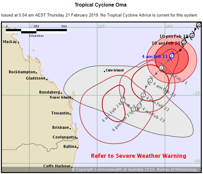
Date: 21/02/2019 07:43:40
From: Michael V
ID: 1349564
Subject: re: Tropical Cyclone Oma
Latest from the BoM:
http://www.bom.gov.au/products/IDQ65002.shtml
Date: 21/02/2019 07:47:56
From: Michael V
ID: 1349565
Subject: re: Tropical Cyclone Oma
Latest from Fiji:
http://www.met.gov.fj/index.php?page=threadmap
Date: 21/02/2019 07:53:17
From: Michael V
ID: 1349567
Subject: re: Tropical Cyclone Oma
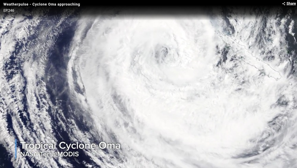
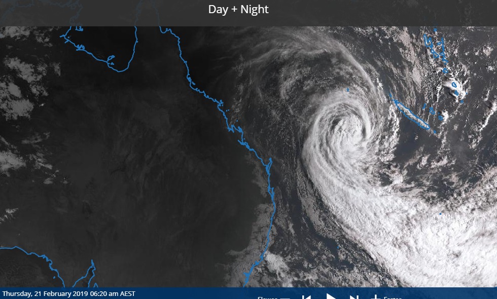
Latest BoM satellite image. Oma looks less ferocious than this time yesterday.
http://satview.bom.gov.au/
Date: 21/02/2019 08:00:18
From: Michael V
ID: 1349568
Subject: re: Tropical Cyclone Oma
https://www.abc.net.au/news/2019-02-21/cyclone-oma-less-likely-to-make-landfall-bom-says/10831036
Date: 21/02/2019 08:03:53
From: Michael V
ID: 1349569
Subject: re: Tropical Cyclone Oma
Some of the words under the Bom’s track map. URL immediately below.
http://www.bom.gov.au/products/IDQ65002.shtml
………………………………………………………………………………………………………………………………………
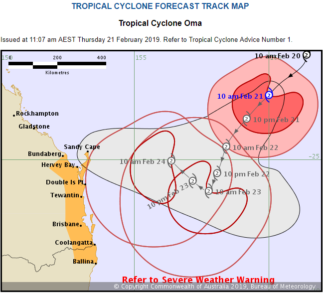
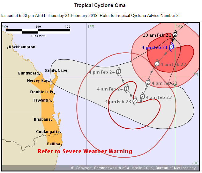
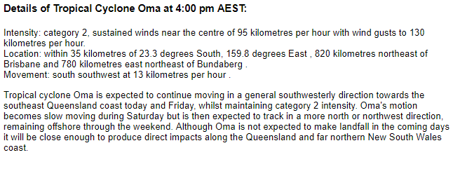
Details of Tropical Cyclone Oma at 4:00 am AEST:
Intensity: category 2, sustained winds near the centre of 95 kilometres per hour with wind gusts to 130 kilometres per hour.
Location: within 55 kilometres of 22.1 degrees South, 160.5 degrees East , 960 kilometres northeast of Brisbane .
Movement: south southwest at 8 kilometres per hour .
Tropical Cyclone Oma is expected to continue moving in a general southwesterly direction for the next couple of days whilst maintaining category 2 intensity, bringing it closer to the southeast Queensland coast on Friday. Oma’s motion becomes slow moving and more uncertain over the weekend, possibly taking a more northwest track off the Queensland coast. Oma may still be close enough to produce direct impacts along the Queensland coast even if it does not make landfall.
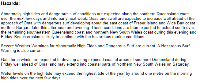
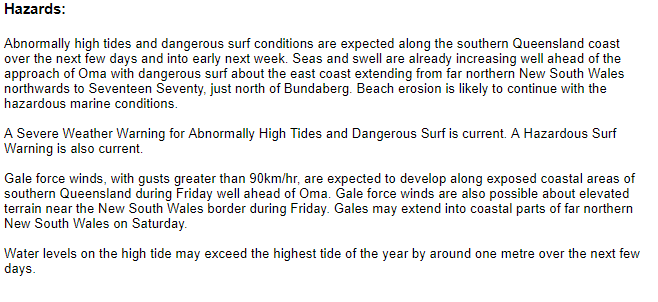
Hazards:
Abnormally high tides and dangerous surf conditions are expected along the southern Queensland coast over the next few days and into early next week. Seas and swell are also expected to increase well ahead of the approach of Oma. A Severe Weather Warning for Abnormally High Tides and Dangerous Surf and a Hazardous Surf Warning are current.
Gale force winds are expected to develop along exposed coastal areas of southern Queensland during Friday well ahead of Oma.
Date: 21/02/2019 09:15:17
From: Michael V
ID: 1349581
Subject: re: Tropical Cyclone Oma
Interesting story with some pictures from the 1893 Brisbane floods.
https://www.abc.net.au/news/2019-02-21/cyclone-oma-is-not-the-first-cyclone-to-threaten-brisbane/10829026
Date: 21/02/2019 09:17:36
From: Ian
ID: 1349582
Subject: re: Tropical Cyclone Oma
Date: 21/02/2019 09:18:39
From: Michael V
ID: 1349583
Subject: re: Tropical Cyclone Oma
Windy.com’s latest model shows Oma coming near here, then northwards, but well away from the coast, to cross north of Mackay with lots of rain there (again).
Date: 21/02/2019 09:21:08
From: Ian
ID: 1349585
Subject: re: Tropical Cyclone Oma
Michael V said:
Windy.com’s latest model shows Oma coming near here, then northwards, but well away from the coast, to cross north of Mackay with lots of rain there (again).
Well that’s no good from my point of view :)
Date: 21/02/2019 09:22:05
From: Divine Angel
ID: 1349586
Subject: re: Tropical Cyclone Oma
Michael V said:
Windy.com’s latest model shows Oma coming near here, then northwards, but well away from the coast, to cross north of Mackay with lots of rain there (again).
That trough/TC just looooooooves that area.
Date: 21/02/2019 09:23:21
From: Michael V
ID: 1349587
Subject: re: Tropical Cyclone Oma
Ian said:
Michael V said:
Windy.com’s latest model shows Oma coming near here, then northwards, but well away from the coast, to cross north of Mackay with lots of rain there (again).
Well that’s no good from my point of view :)
Nor mine, really. That model has us with very little rain.
Date: 21/02/2019 09:35:31
From: Peak Warming Man
ID: 1349588
Subject: re: Tropical Cyclone Oma
Michael V said:
Ian said:
Michael V said:
Windy.com’s latest model shows Oma coming near here, then northwards, but well away from the coast, to cross north of Mackay with lots of rain there (again).
Well that’s no good from my point of view :)
Nor mine, really. That model has us with very little rain.
shakes fist at Oma
Date: 21/02/2019 09:43:39
From: Tamb
ID: 1349590
Subject: re: Tropical Cyclone Oma
Peak Warming Man said:
Michael V said:
Ian said:
Well that’s no good from my point of view :)
Nor mine, really. That model has us with very little rain.
shakes fist at Oma
Latest BOM 
Date: 21/02/2019 09:48:00
From: Divine Angel
ID: 1349591
Subject: re: Tropical Cyclone Oma
I’m constantly shaking my head and rolling my eyes at Oma.
Date: 21/02/2019 11:40:56
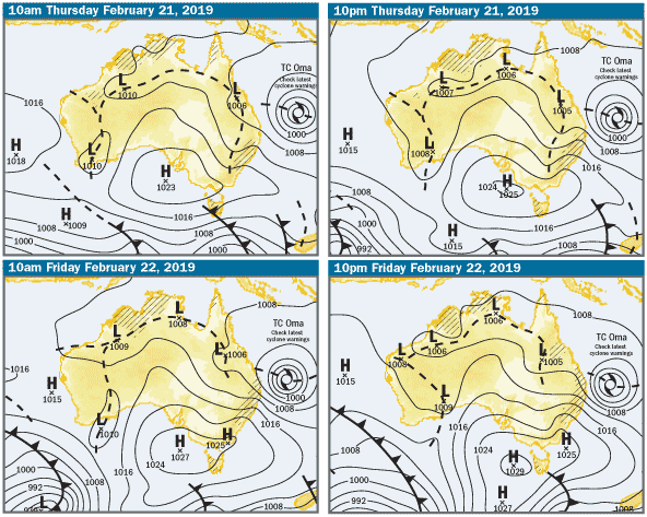
From: Dropbear
ID: 1349663
Subject: re: Tropical Cyclone Oma
Date: 21/02/2019 11:44:05
From: Dropbear
ID: 1349666
Subject: re: Tropical Cyclone Oma
There’s a high pressure ridge in the Tasman which is probably going to block the southerly movement of the storm and send it north.. … we’re saved… no one gives a shit about QLD north of noosa.
Date: 21/02/2019 11:46:37
From: Tamb
ID: 1349667
Subject: re: Tropical Cyclone Oma
Dropbear said:
There’s a high pressure ridge in the Tasman which is probably going to block the southerly movement of the storm and send it north.. … we’re saved… no one gives a shit about QLD north of noosa.
Oh great. I have to go to Cairns at the end of the month. Looks like it will be just in time for Oma. :(
Date: 21/02/2019 11:47:16
From: Dropbear
ID: 1349669
Subject: re: Tropical Cyclone Oma
Tamb said:
Dropbear said:
There’s a high pressure ridge in the Tasman which is probably going to block the southerly movement of the storm and send it north.. … we’re saved… no one gives a shit about QLD north of noosa.
Oh great. I have to go to Cairns at the end of the month. Looks like it will be just in time for Oma. :(
nah …. I think it’s going to be felt more rocky/mackay …all depends when it hooks a right
Date: 21/02/2019 11:58:30
From: Michael V
ID: 1349675
Subject: re: Tropical Cyclone Oma
Dropbear said:
There’s a high pressure ridge in the Tasman which is probably going to block the southerly movement of the storm and send it north.. … we’re saved… no one gives a shit about QLD north of noosa.
Nice bar-steward you turned out to be…
Date: 21/02/2019 11:59:55
From: Dropbear
ID: 1349676
Subject: re: Tropical Cyclone Oma
Michael V said:
Dropbear said:
There’s a high pressure ridge in the Tasman which is probably going to block the southerly movement of the storm and send it north.. … we’re saved… no one gives a shit about QLD north of noosa.
Nice bar-steward you turned out to be…
heheheeh
;)
to be fair I have better things to do than look for wankers who fall off their windsurfers in 40 kts..
Date: 21/02/2019 12:03:14
From: Dropbear
ID: 1349682
Subject: re: Tropical Cyclone Oma
Weather Situation: At 10am AEST Thursday, tropical cyclone Oma (category 2) was situated over the southern Coral Sea, approximately 890 kilometres northeast of Brisbane, and moving in a southwesterly direction. Oma is expected to continue moving in a general southwesterly direction towards southeast Queensland during during today and into Friday, whilst maintaining category 2 intensity.
Dangerous surf conditions are forecast to develop about the east coast of Fraser Island and Wide Bay coast between about Seventeen Seventy and Bargara later this afternoon and evening. These conditions are then expected to extend southwards along the remainder of the southeast Queensland coast, including the Sunshine Coast and Gold Coast, during this evening and Friday.
Water levels on the morning high tide are likely to exceed the highest tide of the year along the southeast Queensland coast during today and Friday. Water levels may exceed the highest tide of the year by around one metre about beachfront areas exposed to wave action.
Beach erosion is likely to continue due to a combination of the increasing surf and abnormally high tides.
Locations which may be affected include Gold Coast, Maroochydore, Moreton Island, Noosa Heads, Caloundra, Rainbow Beach, Fraser Island and Seventeen Seventy.
A Tropical Cyclone Watch will soon be issued for areas between Bundaberg and Ballina (NSW).
http://www.bom.gov.au/products/IDQ21037.shtml
(10:54am)
Date: 21/02/2019 12:06:22
From: Michael V
ID: 1349684
Subject: re: Tropical Cyclone Oma
Dropbear said:
Michael V said:
Dropbear said:
There’s a high pressure ridge in the Tasman which is probably going to block the southerly movement of the storm and send it north.. … we’re saved… no one gives a shit about QLD north of noosa.
Nice bar-steward you turned out to be…
heheheeh
;)
to be fair I have better things to do than look for wankers who fall off their windsurfers in 40 kts..
Some mothers do have them.
Date: 21/02/2019 12:09:21
From: Cymek
ID: 1349685
Subject: re: Tropical Cyclone Oma
Michael V said:
Dropbear said:
Michael V said:
Nice bar-steward you turned out to be…
heheheeh
;)
to be fair I have better things to do than look for wankers who fall off their windsurfers in 40 kts..
Some mothers do have them.
You do have to be quite frank about them
Date: 21/02/2019 12:14:53
From: Michael V
ID: 1349687
Subject: re: Tropical Cyclone Oma
Latest on Oma from BoM – now there’s a declared watch zone:
http://www.bom.gov.au/products/IDQ65002.shtml
Date: 21/02/2019 12:18:19
From: Divine Angel
ID: 1349689
Subject: re: Tropical Cyclone Oma
I can report Moreton Bay at Redcliffe is rather choppy and higher-than-normal waves hitting the shore. Then again, Moreton at Reddy is normally dead flat thanks to Moreton Island.
Date: 21/02/2019 12:39:54
From: Ian
ID: 1349717
Subject: re: Tropical Cyclone Oma
BOM has issued cyclone warning from Bundaberg to Ballina.
Date: 21/02/2019 12:46:24
From: Dropbear
ID: 1349722
Subject: re: Tropical Cyclone Oma
Ian said:
BOM has issued cyclone warning from Bundaberg to Ballina.
i been everywhere man
Date: 21/02/2019 12:48:41
From: Ian
ID: 1349726
Subject: re: Tropical Cyclone Oma
Dropbear said:
Ian said:
BOM has issued cyclone warning from Bundaberg to Ballina.
i been everywhere man
See Ballina and die
Date: 21/02/2019 13:10:28
From: mollwollfumble
ID: 1349741
Subject: re: Tropical Cyclone Oma
Divine Angel said:
I can report Moreton Bay at Redcliffe is rather choppy and higher-than-normal waves hitting the shore. Then again, Moreton at Reddy is normally dead flat thanks to Moreton Island.
> Then again, Moreton at Reddy is normally dead flat thanks to Moreton Island.
That matches my memory.
I’m extremely interested to know whether the place I used to live in gets flooded by the storm surge. Pummicestone Passage.
Date: 21/02/2019 13:12:35
From: Dropbear
ID: 1349743
Subject: re: Tropical Cyclone Oma
mollwollfumble said:
Divine Angel said:
I can report Moreton Bay at Redcliffe is rather choppy and higher-than-normal waves hitting the shore. Then again, Moreton at Reddy is normally dead flat thanks to Moreton Island.
> Then again, Moreton at Reddy is normally dead flat thanks to Moreton Island.
That matches my memory.
I’m extremely interested to know whether the place I used to live in gets flooded by the storm surge. Pummicestone Passage.
nice place that
Date: 21/02/2019 14:26:35
From: Michael V
ID: 1349823
Subject: re: Tropical Cyclone Oma
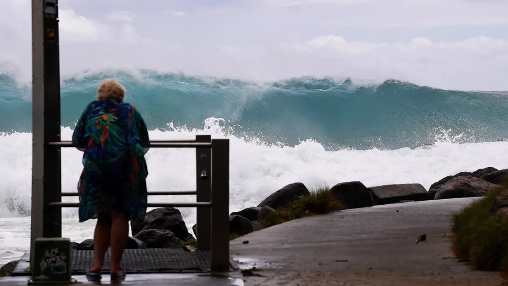
The wind has picked up quite a bit from this morning. Here it’s currently a gusty strong breeze. Double Island point is recording near-gale conditions.
Date: 21/02/2019 14:31:46
From: Dropbear
ID: 1349828
Subject: re: Tropical Cyclone Oma
Michael V said:
The wind has picked up quite a bit from this morning. Here it’s currently a gusty strong breeze. Double Island point is recording near-gale conditions.
How is Gale?
Date: 21/02/2019 14:33:28
From: Dropbear
ID: 1349829
Subject: re: Tropical Cyclone Oma
Michael V said:
The wind has picked up quite a bit from this morning. Here it’s currently a gusty strong breeze. Double Island point is recording near-gale conditions.
38 kts max gust at DIP… no need to panic just yet
http://www.bom.gov.au/products/IDQ60801/IDQ60801.94584.shtml
You can see it’s on the rise though
Date: 21/02/2019 14:36:02
From: Zarkov
ID: 1349831
Subject: re: Tropical Cyclone Oma
Dropbear said:
Michael V said:
The wind has picked up quite a bit from this morning. Here it’s currently a gusty strong breeze. Double Island point is recording near-gale conditions.
38 kts max gust at DIP… no need to panic just yet
http://www.bom.gov.au/products/IDQ60801/IDQ60801.94584.shtml
You can see it’s on the rise though
Caused by the oil layer on the ocean
Date: 21/02/2019 14:37:45
From: Dropbear
ID: 1349832
Subject: re: Tropical Cyclone Oma
Zarkov said:
Caused by the oil layer on the ocean
fuck off, dipshit.
Date: 21/02/2019 14:40:40
From: sibeen
ID: 1349836
Subject: re: Tropical Cyclone Oma
Michael V said:
The wind has picked up quite a bit from this morning. Here it’s currently a gusty strong breeze. Double Island point is recording near-gale conditions.
Double Island point is nowhere near two islands. Stoopid queenslanders.
Date: 21/02/2019 14:41:23
From: Michael V
ID: 1349837
Subject: re: Tropical Cyclone Oma
Dropbear said:
Michael V said:
The wind has picked up quite a bit from this morning. Here it’s currently a gusty strong breeze. Double Island point is recording near-gale conditions.
How is Gale?
Shoosh, you!
Date: 21/02/2019 14:43:53
From: Michael V
ID: 1349840
Subject: re: Tropical Cyclone Oma
Dropbear said:
Michael V said:
The wind has picked up quite a bit from this morning. Here it’s currently a gusty strong breeze. Double Island point is recording near-gale conditions.
38 kts max gust at DIP… no need to panic just yet
http://www.bom.gov.au/products/IDQ60801/IDQ60801.94584.shtml
You can see it’s on the rise though
No panic. Just reporting, using the Beaufort Wind Scale.
Date: 21/02/2019 14:44:06
From: Zarkov
ID: 1349841
Subject: re: Tropical Cyclone Oma
Dropbear said:
Zarkov said:
Caused by the oil layer on the ocean
fuck off, dipshit.

Date: 21/02/2019 14:44:17
From: Michael V
ID: 1349842
Subject: re: Tropical Cyclone Oma
Zarkov said:
Dropbear said:
Michael V said:
The wind has picked up quite a bit from this morning. Here it’s currently a gusty strong breeze. Double Island point is recording near-gale conditions.
38 kts max gust at DIP… no need to panic just yet
http://www.bom.gov.au/products/IDQ60801/IDQ60801.94584.shtml
You can see it’s on the rise though
Caused by the oil layer on the ocean
Nonsense!
Date: 21/02/2019 14:46:14
From: Michael V
ID: 1349845
Subject: re: Tropical Cyclone Oma
sibeen said:
Michael V said:
The wind has picked up quite a bit from this morning. Here it’s currently a gusty strong breeze. Double Island point is recording near-gale conditions.
Double Island point is nowhere near two islands. Stoopid queenslanders.
Poms, you mean. It was Captain Cook who named it in 1770. Originally as “Double Island”, but revised when he go closer and saw the feature was attached to the mainland.
Date: 21/02/2019 14:48:49
From: Zarkov
ID: 1349846
Subject: re: Tropical Cyclone Oma
Zarkov said:
Dropbear said:
Zarkov said:
Caused by the oil layer on the ocean
fuck off, dipshit.
Why are you calling yourself names
Date: 21/02/2019 14:51:01
From: Peak Warming Man
ID: 1349848
Subject: re: Tropical Cyclone Oma
Michael V said:
sibeen said:
Michael V said:
The wind has picked up quite a bit from this morning. Here it’s currently a gusty strong breeze. Double Island point is recording near-gale conditions.
Double Island point is nowhere near two islands. Stoopid queenslanders.
Poms, you mean. It was Captain Cook who named it in 1770. Originally as “Double Island”, but revised when he go closer and saw the feature was attached to the mainland.
He was a migrant, came to Australia and stayed for a month or two near Cooktown and all he did was whinge, it’s too hot, too many mossies, on and on he went, shithouse country, no vegetables……. on and on, whinge whinge whinge.
And then he fucked off home.
Date: 21/02/2019 14:54:56
From: ChrispenEvan
ID: 1349850
Subject: re: Tropical Cyclone Oma
Peak Warming Man said:
Michael V said:
sibeen said:
Double Island point is nowhere near two islands. Stoopid queenslanders.
Poms, you mean. It was Captain Cook who named it in 1770. Originally as “Double Island”, but revised when he go closer and saw the feature was attached to the mainland.
He was a migrant, came to Australia and stayed for a month or two near Cooktown and all he did was whinge, it’s too hot, too many mossies, on and on he went, shithouse country, no vegetables……. on and on, whinge whinge whinge.
And then he fucked off home.
typical yorkshireman. like boycott.
Date: 21/02/2019 15:35:36
From: Ian
ID: 1349861
Subject: re: Tropical Cyclone Oma
Ian said:
BOM has issued cyclone warning from Bundaberg to Ballina.
CORRECTION: There is no cyclone warning so you can stand down.
There is a cyclone watch however so don’t lie down. (at least keep one eye open if you do)
:)
Date: 21/02/2019 15:42:50
From: Michael V
ID: 1349865
Subject: re: Tropical Cyclone Oma
ChrispenEvan said:
Peak Warming Man said:
Michael V said:
Poms, you mean. It was Captain Cook who named it in 1770. Originally as “Double Island”, but revised when he go closer and saw the feature was attached to the mainland.
He was a migrant, came to Australia and stayed for a month or two near Cooktown and all he did was whinge, it’s too hot, too many mossies, on and on he went, shithouse country, no vegetables……. on and on, whinge whinge whinge.
And then he fucked off home.
typical yorkshireman. like boycott.
snigger
Date: 21/02/2019 16:15:57
From: Dropbear
ID: 1349874
Subject: re: Tropical Cyclone Oma
very close to Gale Force winds now at Cape Moreton and Double Island point (32 knots).. Gale Force officially starts at 34 knots sustained surface winds.
Date: 21/02/2019 16:17:45
From: Cymek
ID: 1349875
Subject: re: Tropical Cyclone Oma
Dropbear said:
very close to Gale Force winds now at Cape Moreton and Double Island point (32 knots).. Gale Force officially starts at 34 knots sustained surface winds.
Forcing wind is probably not good for Gale
Date: 21/02/2019 16:46:30
From: Tamb
ID: 1349876
Subject: re: Tropical Cyclone Oma
Cymek said:
Dropbear said:
very close to Gale Force winds now at Cape Moreton and Double Island point (32 knots).. Gale Force officially starts at 34 knots sustained surface winds.
Forcing wind is probably not good for Gale
It’s unsustainable.
Date: 21/02/2019 16:57:50
From: Dropbear
ID: 1349878
Subject: re: Tropical Cyclone Oma
Peak Warming Man said:
Michael V said:
sibeen said:
Double Island point is nowhere near two islands. Stoopid queenslanders.
Poms, you mean. It was Captain Cook who named it in 1770. Originally as “Double Island”, but revised when he go closer and saw the feature was attached to the mainland.
He was a migrant, came to Australia and stayed for a month or two near Cooktown and all he did was whinge, it’s too hot, too many mossies, on and on he went, shithouse country, no vegetables……. on and on, whinge whinge whinge.
And then he fucked off home.
Sounds like a great number of poms that came here – except for the Cooktown bit
Date: 21/02/2019 18:45:24
From: Divine Angel
ID: 1349916
Subject: re: Tropical Cyclone Oma
Currently gusting at 72kph and getting stronger.
Date: 21/02/2019 18:46:36
From: Michael V
ID: 1349917
Subject: re: Tropical Cyclone Oma
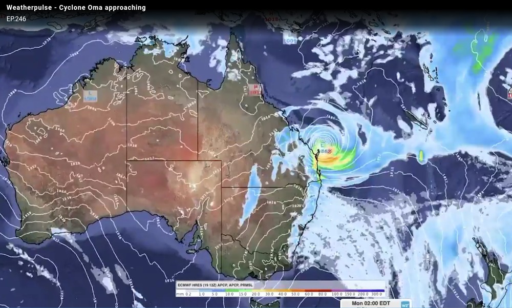
Latest BoM track map and gale watch areas:
Date: 21/02/2019 18:58:48
From: Divine Angel
ID: 1349929
Subject: re: Tropical Cyclone Oma
Questions from Mini Me:
Will the cyclone hit us?
Will the cyclone hit the playground?
Will the cyclone hit the library?
Will the cyclone hit Oma’s house?
Will the cyclone hit open Mic?
Dorothy doesn’t like cyclones. Will the cyclone take me to the wizard of Oz?
Date: 21/02/2019 19:01:16
From: Michael V
ID: 1349934
Subject: re: Tropical Cyclone Oma
Divine Angel said:
Questions from Mini Me:
Will the cyclone hit us?
Will the cyclone hit the playground?
Will the cyclone hit the library?
Will the cyclone hit Oma’s house?
Will the cyclone hit open Mic?
Dorothy doesn’t like cyclones. Will the cyclone take me to the wizard of Oz?
Oh the joy…
Date: 21/02/2019 19:15:27
From: Michael V
ID: 1349952
Subject: re: Tropical Cyclone Oma
Image posted in chat by PWM:
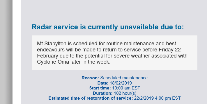
“Oh, lets turn it off for four days so we can replace the wigwam to a gooses bridle bit.” says the BoM head technician.
I guess they’ve still got the old Marburg radar…
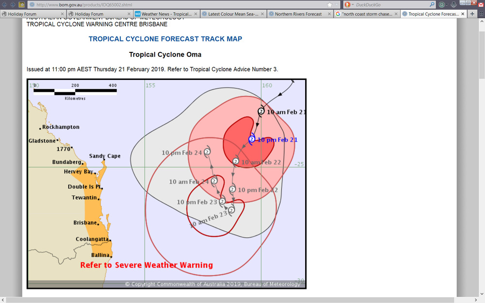
Date: 22/02/2019 02:44:46
From: Ian
ID: 1350118
Subject: re: Tropical Cyclone Oma
Feb 21
The category 2 cyclone is sitting about 890km northeast of Brisbane, noticeably closer than the 950km distance recorded this morning.
Oma is currently travelling southwest at 11km/h and is expected to continue moving towards the southeast cost of Queensland today and tomorrow.
Earlier forecasters thought it was becoming less likely that the tropical cyclone would cross the Queensland coast.
Bureau of Meteorology senior forecaster Jonty Hall said Oma will maintain its slow path towards the coast until tomorrow.
After that, its behaviour is less predictable.
—
There is a reasonable consensus that Oma will be on that NNW track by 24th however there are 20 models all showing different things happening after that including…
Wandering around in much the same area
Turning back toward the SE Qld coast
Tracking all the way up to Cairns
Tracking all the way down to Port Macquarie
Date: 22/02/2019 02:49:56
From: Bubblecar
ID: 1350119
Subject: re: Tropical Cyclone Oma
I wonder if exploding a nuclear bomb in the middle of a cyclone would disperse it.
Date: 22/02/2019 03:08:47
From: Ian
ID: 1350120
Subject: re: Tropical Cyclone Oma
Bubblecar said:
I wonder if exploding a nuclear bomb in the middle of a cyclone would disperse it.
Nah. Probly just make it angry.
Date: 22/02/2019 08:18:36
From: Divine Angel
ID: 1350128
Subject: re: Tropical Cyclone Oma
Ian said:
Bubblecar said:
I wonder if exploding a nuclear bomb in the middle of a cyclone would disperse it.
Nah. Probly just make it angry.
Never piss off a Dutch or German woman.
Date: 22/02/2019 08:21:01
From: Divine Angel
ID: 1350129
Subject: re: Tropical Cyclone Oma
Winds gusting at 65 kph. We got a few drops of rain last night.
Date: 22/02/2019 08:23:58
From: roughbarked
ID: 1350130
Subject: re: Tropical Cyclone Oma
Divine Angel said:
Winds gusting at 65 kph. We got a few drops of rain last night.
Looks like most of the rain fell south of the border overnight.
Date: 22/02/2019 08:59:29
From: Ian
ID: 1350134
Subject: re: Tropical Cyclone Oma
Been feeling the influence of Oma overnight. Winds gusting to 31 km/h.
1.5 mm rain. (nearby locations got 30, 60 mm (grrr))
The surfers seem to be enjoying it. I feel a trip to the coast coming on :)
nigj
Date: 22/02/2019 09:09:18
From: mollwollfumble
ID: 1350135
Subject: re: Tropical Cyclone Oma
Bubblecar said:
I wonder if exploding a nuclear bomb in the middle of a cyclone would disperse it.
That question used to be favourite one in cold war times.
The simple answer is “no”, a hurricane contains too much energy.
A more complicated answer is that a hurricane feeds off heat. Adding an atomic blast adds to that heat. It would intensify the hurricane, slightly.
Date: 22/02/2019 09:11:07
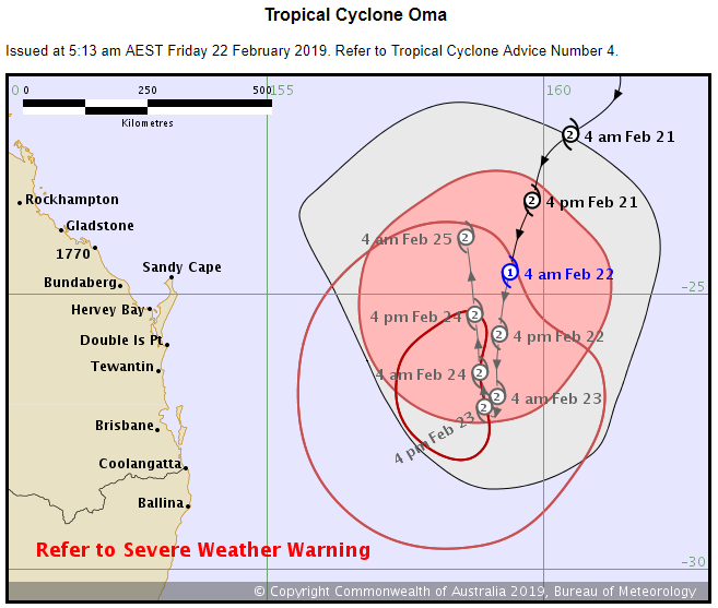
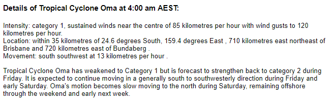
From: Michael V
ID: 1350136
Subject: re: Tropical Cyclone Oma
Latest track map from BoM. Oma is now a Cat 1 storm, but expected to go back to Cat 2 again today. The cyclone watch and zone has been cancelled. We got a little rain last night, including one very heavy but short shower. All up, about 2 mm.
Date: 22/02/2019 09:15:32
From: mollwollfumble
ID: 1350137
Subject: re: Tropical Cyclone Oma
Michael V said:
Latest track map from BoM. Oma is now a Cat 1 storm, but expected to go back to Cat 2 again today. The cyclone watch and zone has been cancelled. We got a little rain last night, including one very heavy but short shower. All up, about 2 mm.
> The cyclone watch and zone has been cancelled.
That’s good news. I think.
Date: 22/02/2019 09:27:46
From: Michael V
ID: 1350139
Subject: re: Tropical Cyclone Oma
mollwollfumble said:
Michael V said:
Latest track map from BoM. Oma is now a Cat 1 storm, but expected to go back to Cat 2 again today. The cyclone watch and zone has been cancelled. We got a little rain last night, including one very heavy but short shower. All up, about 2 mm.
> The cyclone watch and zone has been cancelled.
That’s good news. I think.
Yeah. Pretty much.
But I was looking forward to some rain and wind. I’ve even weighted down the stuff in the yard I think night become missiles, or moved them to shelter in the garage or house.
Date: 22/02/2019 09:43:50
From: Peak Warming Man
ID: 1350146
Subject: re: Tropical Cyclone Oma
It’s a big disappointment, delivering no rain anywhere that I want.
Cyclone Oma is going on my list of things that can get fucked.
Date: 22/02/2019 10:04:16
From: Michael V
ID: 1350149
Subject: re: Tropical Cyclone Oma
Peak Warming Man said:
It’s a big disappointment, delivering no rain anywhere that I want.
Cyclone Oma is going on my list of things that can get fucked.
LOL
Date: 22/02/2019 10:07:31
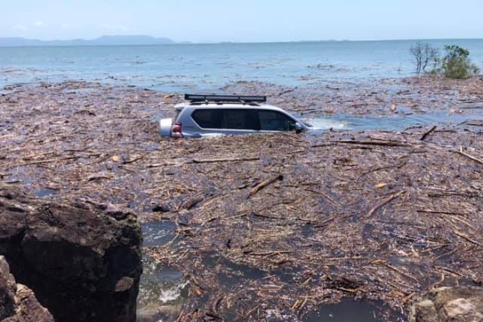
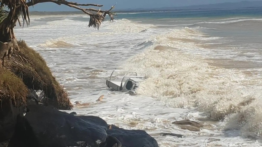
From: Ian
ID: 1350150
Subject: re: Tropical Cyclone Oma
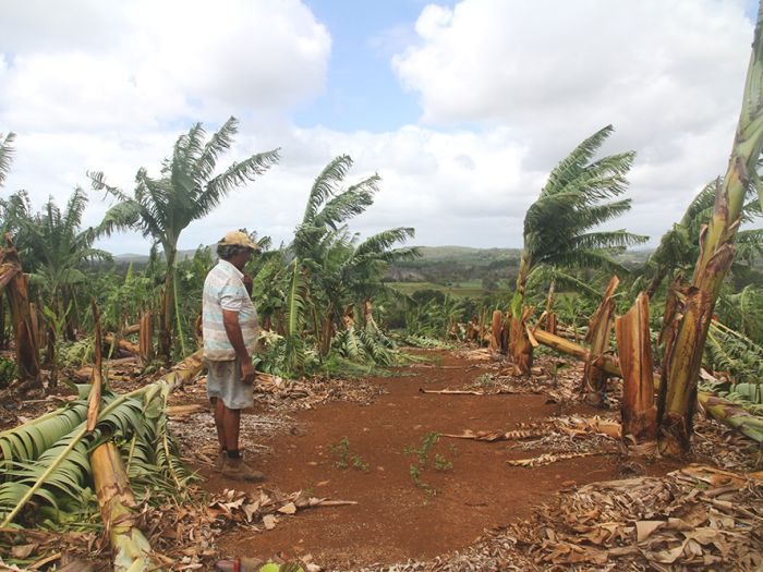
Parking spots at a premium… above at Rainbow Beach
Date: 22/02/2019 10:20:53
From: Ian
ID: 1350151
Subject: re: Tropical Cyclone Oma
Peak Warming Man said:
It’s a big disappointment, delivering no rain anywhere that I want.
Cyclone Oma is going on my list of things that can get fucked.
Above paddock trees?
Date: 22/02/2019 10:27:56
From: Michael V
ID: 1350152
Subject: re: Tropical Cyclone Oma
Ian said:
Parking spots at a premium… above at Rainbow Beach
LOL.
What a fool. Big waves plus a high King Tide has eroded the beach, so he tries to drive around the exposed rocks…
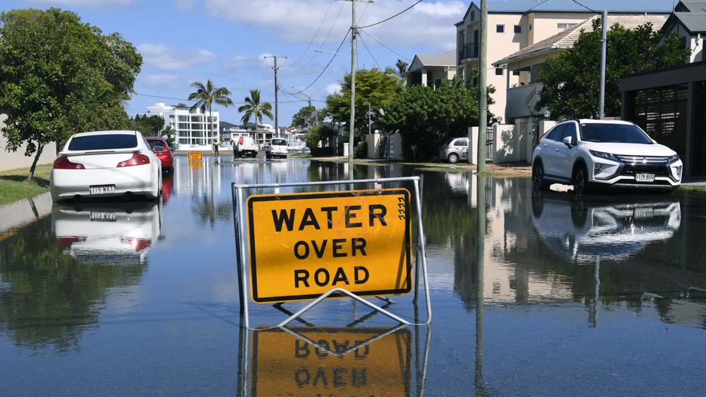
Date: 22/02/2019 10:45:17
From: Michael V
ID: 1350155
Subject: re: Tropical Cyclone Oma
First blackout. It’s been reset quickly though. There may be more blackouts. I don’t have the internet without electricity, so I may be gone some little while if there is a major disruption to electricity infrastructure.
Off to check the high tide at the beach and Inskip Point.
Date: 22/02/2019 13:17:38
From: buffy
ID: 1350259
Subject: re: Tropical Cyclone Oma
Ian said:
Been feeling the influence of Oma overnight. Winds gusting to 31 km/h.
1.5 mm rain. (nearby locations got 30, 60 mm (grrr))
The surfers seem to be enjoying it. I feel a trip to the coast coming on :)
nigj
Was this a tic post? We’ve been gusting in the thirties all morning and we certainly aren’t in the influence of any cyclone. Thirties is a zephyr. I fought to hang out sheets a couple of weeks ago and when I checked, the gusts were 60-70. Dried the sheets very efficiently and removed lots of wrinkles too.
Date: 22/02/2019 13:21:06
From: Tamb
ID: 1350262
Subject: re: Tropical Cyclone Oma
buffy said:
Ian said:
Been feeling the influence of Oma overnight. Winds gusting to 31 km/h.
1.5 mm rain. (nearby locations got 30, 60 mm (grrr))
The surfers seem to be enjoying it. I feel a trip to the coast coming on :)
nigj
Was this a tic post? We’ve been gusting in the thirties all morning and we certainly aren’t in the influence of any cyclone. Thirties is a zephyr. I fought to hang out sheets a couple of weeks ago and when I checked, the gusts were 60-70. Dried the sheets very efficiently and removed lots of wrinkles too.
Looks like it may go away but I don’t like these sort of cyclones. They seem to be looking where they might do the most damage.

Date: 22/02/2019 13:24:40
From: party_pants
ID: 1350263
Subject: re: Tropical Cyclone Oma
Tamb said:
buffy said:
Ian said:
Been feeling the influence of Oma overnight. Winds gusting to 31 km/h.
1.5 mm rain. (nearby locations got 30, 60 mm (grrr))
The surfers seem to be enjoying it. I feel a trip to the coast coming on :)
nigj
Was this a tic post? We’ve been gusting in the thirties all morning and we certainly aren’t in the influence of any cyclone. Thirties is a zephyr. I fought to hang out sheets a couple of weeks ago and when I checked, the gusts were 60-70. Dried the sheets very efficiently and removed lots of wrinkles too.
Looks like it may go away but I don’t like these sort of cyclones. They seem to be looking where they might do the most damage.
It’s the big wobbly bubblegum monster and he’s blowing a bubble at southern QLD!
Date: 22/02/2019 13:33:26
From: roughbarked
ID: 1350268
Subject: re: Tropical Cyclone Oma
Michael V said:
Ian said:
Parking spots at a premium… above at Rainbow Beach
LOL.
What a fool. Big waves plus a high King Tide has eroded the beach, so he tries to drive around the exposed rocks…
Clearly people who shouldn’t be allowed to have cars.
Date: 22/02/2019 13:36:06
From: mollwollfumble
ID: 1350272
Subject: re: Tropical Cyclone Oma
Tamb said:
buffy said:
Ian said:
Been feeling the influence of Oma overnight. Winds gusting to 31 km/h.
1.5 mm rain. (nearby locations got 30, 60 mm (grrr))
The surfers seem to be enjoying it. I feel a trip to the coast coming on :)
nigj
Was this a tic post? We’ve been gusting in the thirties all morning and we certainly aren’t in the influence of any cyclone. Thirties is a zephyr. I fought to hang out sheets a couple of weeks ago and when I checked, the gusts were 60-70. Dried the sheets very efficiently and removed lots of wrinkles too.
Looks like it may go away but I don’t like these sort of cyclones. They seem to be looking where they might do the most damage.
Cyclone track going epicycle?

Date: 22/02/2019 13:45:54
From: Ian
ID: 1350278
Subject: re: Tropical Cyclone Oma
buffy said:
Ian said:
Been feeling the influence of Oma overnight. Winds gusting to 31 km/h.
1.5 mm rain. (nearby locations got 30, 60 mm (grrr))
The surfers seem to be enjoying it. I feel a trip to the coast coming on :)
nigj
Was this a tic post? We’ve been gusting in the thirties all morning and we certainly aren’t in the influence of any cyclone. Thirties is a zephyr. I fought to hang out sheets a couple of weeks ago and when I checked, the gusts were 60-70. Dried the sheets very efficiently and removed lots of wrinkles too.
Huh? Was this a tic post? A zephyr is a light breeze.. 6 – 11 km/h
The coast is under a warning for gale force winds. Currently gusting to 65 km/h
Your abilty to hang sheets in a gale does not concern me.
Date: 22/02/2019 14:04:12
From: Ian
ID: 1350285
Subject: re: Tropical Cyclone Oma
mollwollfumble said:
Tamb said:
buffy said:
Was this a tic post? We’ve been gusting in the thirties all morning and we certainly aren’t in the influence of any cyclone. Thirties is a zephyr. I fought to hang out sheets a couple of weeks ago and when I checked, the gusts were 60-70. Dried the sheets very efficiently and removed lots of wrinkles too.
Looks like it may go away but I don’t like these sort of cyclones. They seem to be looking where they might do the most damage.
Cyclone track going epicycle?
Probably as good as any prediction.
48 hrs ago BOM was predicting rainfall totals of around 300 mm over the weekend. Now, almost zero except for some showers on the very coastal strip.
Date: 22/02/2019 14:05:37
From: roughbarked
ID: 1350287
Subject: re: Tropical Cyclone Oma
Ian said:
mollwollfumble said:
Tamb said:
Looks like it may go away but I don’t like these sort of cyclones. They seem to be looking where they might do the most damage.
Cyclone track going epicycle?
Probably as good as any prediction.
48 hrs ago BOM was predicting rainfall totals of around 300 mm over the weekend. Now, almost zero except for some showers on the very coastal strip.
the high down south has held up it’s progress and will push it back.
Date: 22/02/2019 14:14:13
From: Ian
ID: 1350297
Subject: re: Tropical Cyclone Oma
roughbarked said:
Ian said:
mollwollfumble said:
Cyclone track going epicycle?
Probably as good as any prediction.
48 hrs ago BOM was predicting rainfall totals of around 300 mm over the weekend. Now, almost zero except for some showers on the very coastal strip.
the high down south has held up it’s progress and will push it back.
Back to where though?
Date: 22/02/2019 14:15:27
From: roughbarked
ID: 1350300
Subject: re: Tropical Cyclone Oma
Ian said:
roughbarked said:
Ian said:
Probably as good as any prediction.
48 hrs ago BOM was predicting rainfall totals of around 300 mm over the weekend. Now, almost zero except for some showers on the very coastal strip.
the high down south has held up it’s progress and will push it back.
Back to where though?
North. I doubt it will make land.
Date: 22/02/2019 16:27:12
From: Michael V
ID: 1350374
Subject: re: Tropical Cyclone Oma
Michael V said:
First blackout. It’s been reset quickly though. There may be more blackouts. I don’t have the internet without electricity, so I may be gone some little while if there is a major disruption to electricity infrastructure.
Off to check the high tide at the beach and Inskip Point.
Blackout until a few minutes ago.
High tide at Inskip Point: Much erosion happening. Lots of trees have been toppled and washed into sea. Water much higher than I’ve ever seen it.
At Rainbow Beach beach: higher than it’s been for a couple of years at least. Eroding back into the shallow sand-cliff near the base of the low fore-dune. 2-4 m surf. Water brown.
There’s been some very strong wind gusts; it’s blowing a gale…
Date: 22/02/2019 16:29:42
From: Michael V
ID: 1350376
Subject: re: Tropical Cyclone Oma
Tamb said:
buffy said:
Ian said:
Been feeling the influence of Oma overnight. Winds gusting to 31 km/h.
1.5 mm rain. (nearby locations got 30, 60 mm (grrr))
The surfers seem to be enjoying it. I feel a trip to the coast coming on :)
nigj
Was this a tic post? We’ve been gusting in the thirties all morning and we certainly aren’t in the influence of any cyclone. Thirties is a zephyr. I fought to hang out sheets a couple of weeks ago and when I checked, the gusts were 60-70. Dried the sheets very efficiently and removed lots of wrinkles too.
Looks like it may go away but I don’t like these sort of cyclones. They seem to be looking where they might do the most damage.
Heh!
It looks that way…
:)
Date: 22/02/2019 16:52:40
From: Divine Angel
ID: 1350393
Subject: re: Tropical Cyclone Oma
Michael V said:
Michael V said:
First blackout. It’s been reset quickly though. There may be more blackouts. I don’t have the internet without electricity, so I may be gone some little while if there is a major disruption to electricity infrastructure.
Off to check the high tide at the beach and Inskip Point.
Blackout until a few minutes ago.
High tide at Inskip Point: Much erosion happening. Lots of trees have been toppled and washed into sea. Water much higher than I’ve ever seen it.
At Rainbow Beach beach: higher than it’s been for a couple of years at least. Eroding back into the shallow sand-cliff near the base of the low fore-dune. 2-4 m surf. Water brown.
There’s been some very strong wind gusts; it’s blowing a gale…
On Higgins Storm Chasing Facebook page, they’re saying the far side of Moreton island had 13m waves and about the same for Caloundra.
Date: 22/02/2019 16:56:20
From: Michael V
ID: 1350398
Subject: re: Tropical Cyclone Oma
Divine Angel said:
Michael V said:
Michael V said:
First blackout. It’s been reset quickly though. There may be more blackouts. I don’t have the internet without electricity, so I may be gone some little while if there is a major disruption to electricity infrastructure.
Off to check the high tide at the beach and Inskip Point.
Blackout until a few minutes ago.
High tide at Inskip Point: Much erosion happening. Lots of trees have been toppled and washed into sea. Water much higher than I’ve ever seen it.
At Rainbow Beach beach: higher than it’s been for a couple of years at least. Eroding back into the shallow sand-cliff near the base of the low fore-dune. 2-4 m surf. Water brown.
There’s been some very strong wind gusts; it’s blowing a gale…
On Higgins Storm Chasing Facebook page, they’re saying the far side of Moreton island had 13m waves and about the same for Caloundra.
13 metres!
Sounds a bit big to me. At Caloundra, that’d be well into the shopping centre, wouldn’t it?
Date: 22/02/2019 16:58:14
From: roughbarked
ID: 1350400
Subject: re: Tropical Cyclone Oma
Michael V said:
Divine Angel said:
Michael V said:
Blackout until a few minutes ago.
High tide at Inskip Point: Much erosion happening. Lots of trees have been toppled and washed into sea. Water much higher than I’ve ever seen it.
At Rainbow Beach beach: higher than it’s been for a couple of years at least. Eroding back into the shallow sand-cliff near the base of the low fore-dune. 2-4 m surf. Water brown.
There’s been some very strong wind gusts; it’s blowing a gale…
On Higgins Storm Chasing Facebook page, they’re saying the far side of Moreton island had 13m waves and about the same for Caloundra.
13 metres!
Sounds a bit big to me. At Caloundra, that’d be well into the shopping centre, wouldn’t it?
I daresay there will be more images of inundated cars.
Date: 22/02/2019 16:59:14
From: roughbarked
ID: 1350401
Subject: re: Tropical Cyclone Oma
roughbarked said:
Michael V said:
Divine Angel said:
On Higgins Storm Chasing Facebook page, they’re saying the far side of Moreton island had 13m waves and about the same for Caloundra.
13 metres!
Sounds a bit big to me. At Caloundra, that’d be well into the shopping centre, wouldn’t it?
I daresay there will be more images of inundated cars.
Last news I noted which was early this morning, the waves were getting above six metres.
Date: 22/02/2019 17:38:20
From: Ian
ID: 1350421
Subject: re: Tropical Cyclone Oma
Michael V said:
Michael V said:
First blackout. It’s been reset quickly though. There may be more blackouts. I don’t have the internet without electricity, so I may be gone some little while if there is a major disruption to electricity infrastructure.
Off to check the high tide at the beach and Inskip Point.
Blackout until a few minutes ago.
High tide at Inskip Point: Much erosion happening. Lots of trees have been toppled and washed into sea. Water much higher than I’ve ever seen it.
At Rainbow Beach beach: higher than it’s been for a couple of years at least. Eroding back into the shallow sand-cliff near the base of the low fore-dune. 2-4 m surf. Water brown.
There’s been some very strong wind gusts; it’s blowing a gale…
Picsorban
:)
Date: 22/02/2019 17:41:50
From: Michael V
ID: 1350423
Subject: re: Tropical Cyclone Oma
Ian said:
Michael V said:
Michael V said:
First blackout. It’s been reset quickly though. There may be more blackouts. I don’t have the internet without electricity, so I may be gone some little while if there is a major disruption to electricity infrastructure.
Off to check the high tide at the beach and Inskip Point.
Blackout until a few minutes ago.
High tide at Inskip Point: Much erosion happening. Lots of trees have been toppled and washed into sea. Water much higher than I’ve ever seen it.
At Rainbow Beach beach: higher than it’s been for a couple of years at least. Eroding back into the shallow sand-cliff near the base of the low fore-dune. 2-4 m surf. Water brown.
There’s been some very strong wind gusts; it’s blowing a gale…
Picsorban
:)
Ban.
No pics.
Date: 22/02/2019 18:26:33
From: Ian
ID: 1350449
Subject: re: Tropical Cyclone Oma
Date: 22/02/2019 18:33:57
From: buffy
ID: 1350450
Subject: re: Tropical Cyclone Oma
Ian said:
buffy said:
Ian said:
Been feeling the influence of Oma overnight. Winds gusting to 31 km/h.
1.5 mm rain. (nearby locations got 30, 60 mm (grrr))
The surfers seem to be enjoying it. I feel a trip to the coast coming on :)
nigj
Was this a tic post? We’ve been gusting in the thirties all morning and we certainly aren’t in the influence of any cyclone. Thirties is a zephyr. I fought to hang out sheets a couple of weeks ago and when I checked, the gusts were 60-70. Dried the sheets very efficiently and removed lots of wrinkles too.
Huh? Was this a tic post? A zephyr is a light breeze.. 6 – 11 km/h
The coast is under a warning for gale force winds. Currently gusting to 65 km/h
Your abilty to hang sheets in a gale does not concern me.
I was questioning that gusts at 31km/hr were anything out of the ordinary.
Date: 22/02/2019 18:34:46
From: Michael V
ID: 1350451
Subject: re: Tropical Cyclone Oma
Latest from the BoM:
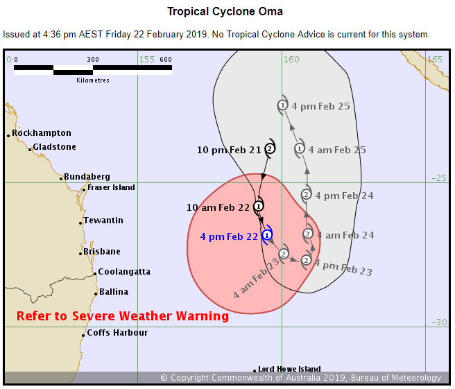
Date: 22/02/2019 18:37:02
From: roughbarked
ID: 1350453
Subject: re: Tropical Cyclone Oma
Michael V said:
Latest from the BoM:
So if it is coming to land, it is still in the same range it was, this morning.
I keep saying that it is the high and highs down south that will keep this off the coast for a while yet.
Date: 23/02/2019 07:43:54
From: Divine Angel
ID: 1350724
Subject: re: Tropical Cyclone Oma
Oma expected to weaken into a tropical low and be de-named this morning.
Well, that was a fizzer.
Date: 23/02/2019 08:01:14
From: roughbarked
ID: 1350725
Subject: re: Tropical Cyclone Oma
Divine Angel said:
Oma expected to weaken into a tropical low and be de-named this morning.
Well, that was a fizzer.
It certainly wet a lot of FNQ before it fizzled.
Date: 23/02/2019 09:21:43
From: Michael V
ID: 1350730
Subject: re: Tropical Cyclone Oma
Latest from the BoM:
So from last night Oma has intensified to Cat 2, but is now “undergoing extratropical transition” and is expected to be de-named. What does this bit of jargon actually mean?
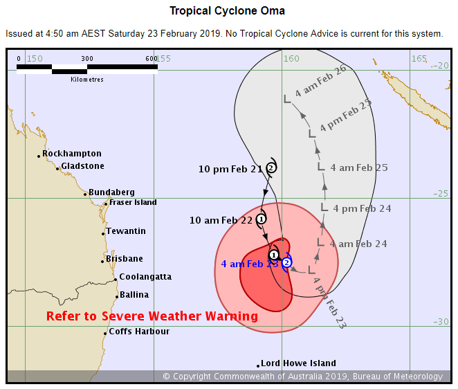
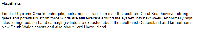
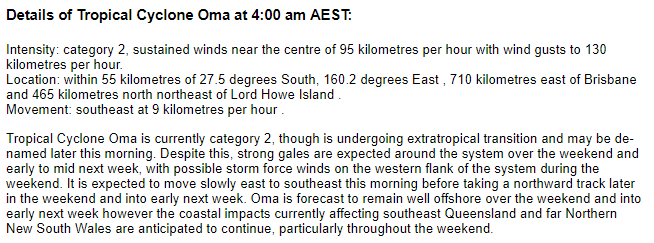
Date: 23/02/2019 09:25:19
From: captain_spalding
ID: 1350734
Subject: re: Tropical Cyclone Oma
Michael V said:
Latest from the BoM:
So from last night Oma has intensified to Cat 2, but is now “undergoing extratropical transition” and is expected to be de-named. What does this bit of jargon actually mean?
It’s like being ‘drummed out of the Army’. The cyclone is paraded in front of its peers, has its badges of rank and regiment torn off, and is forcibly ejected into the wilderness.
It’s the ultimate disgrace for a tropical weather system. some have been known to turn around, and come back stonger than ever as revenge.
Date: 23/02/2019 09:31:05
From: Ian
ID: 1350736
Subject: re: Tropical Cyclone Oma
Divine Angel said:
Oma expected to weaken into a tropical low and be de-named this morning.
Well, that was a fizzer.
Predictions for Oma have changed a half a dozen times this morning. The last one I heard was was the BOM “reckoned” it would turn northward and drop below cyclone strength, but a lot of uncertainty remained.
(New protocols have been instituted at the BOM. One bloke spins another around and around before he/she lobs the darts over the shoulder toward where the dartboard would be positioned if it had not be removed altogether.
ingsnss :)
Date: 23/02/2019 09:41:50
From: captain_spalding
ID: 1350738
Subject: re: Tropical Cyclone Oma
Ian said:
Divine Angel said:
Oma expected to weaken into a tropical low and be de-named this morning.
Well, that was a fizzer.
Predictions for Oma have changed a half a dozen times this morning. The last one I heard was was the BOM “reckoned” it would turn northward and drop below cyclone strength, but a lot of uncertainty remained.
(New protocols have been instituted at the BOM. One bloke spins another around and around before he/she lobs the darts over the shoulder toward where the dartboard would be positioned if it had not be removed altogether.
ingsnss :)
‘The El Niño–Southern Oscillation (ENSO) remains neutral. However, the Bureau’s ENSO Outlook remains at El Niño WATCH, meaning there is approximately a 50% chance of El Niño developing during the southern hemisphere autumn or winter, twice the normal likelihood.’ – BOM website
The BOM like to warn of the approach of El nino like the L/NP likes to warn about ‘the boats’. Like the arival of one of ‘the boats’ for the govt, the arrival of an El Nino is a god-send for BOM. Anytime anything severe and/or unexpected happens anywhere, BOM can just shrug and say, ‘well, El Nino…’
I’m not saying their predictions aren’t accurate or necessary – but having an El Nino makes life rather less complicated for them.
Date: 23/02/2019 09:53:00
From: Ian
ID: 1350739
Subject: re: Tropical Cyclone Oma
Date: 23/02/2019 09:53:53
From: Michael V
ID: 1350740
Subject: re: Tropical Cyclone Oma
https://en.wikipedia.org/wiki/Extratropical_cyclone#Extratropical_transition
It seems that the structure and organisation of the storm changes. The storm may even become bigger and the core becomes weaker.
Date: 23/02/2019 10:02:11
From: Ian
ID: 1350742
Subject: re: Tropical Cyclone Oma
I’m not saying their predictions aren’t accurate or necessary – but having an El Nino makes life rather less complicated for them.
—
But have you factored in Madden-Julian Oscillation?
Date: 23/02/2019 10:03:47
From: Michael V
ID: 1350743
Subject: re: Tropical Cyclone Oma
http://www.bom.gov.au/products/IDQ21037.shtml
“Locally damaging wind gusts in excess of 90 kilometres per hour are likely about the exposed coast and islands between Sandy Cape and the Qld/NSW border today. These damaging wind gusts may extend to the southern border ranges, inland to about Springbrook and Tamborine Mountain, today and into Sunday.
Locations which may be affected include Gold Coast, Maroochydore, Moreton Island, North Stradbroke Island, Noosa Heads, Caloundra, Rainbow Beach, Fraser Island, Tamborine Mountain and Springbrook.
Maximum wave heights of 12-13m recorded at Mooloolaba and off Point Lookout during Friday, which is larger than those recorded in cyclone Oswald.”
I withdraw my comments (yesterday) about 13 metre wave heights. That’s extraordinary. We didn’t have anything like that. Probably 4 metres maximum. (Still bloody big, though!)
Date: 23/02/2019 10:22:59
From: captain_spalding
ID: 1350747
Subject: re: Tropical Cyclone Oma
Ian said:
I’m not saying their predictions aren’t accurate or necessary – but having an El Nino makes life rather less complicated for them.
—
But have you factored in Madden-Julian Oscillation?
No, i was saving that in case anything that BOM says about El Nino etc started to make sense. If that should happen, i coud just lob in the MJO, like a hand grenade, and restore things to normal.
Date: 23/02/2019 10:26:37
From: captain_spalding
ID: 1350748
Subject: re: Tropical Cyclone Oma
‘Canberra’s chaplain community slams what it says is the “ludicrous” decision to ban all chaplains from ACT public schools’ – ABC News
Aww, no more taxpayer-funded religious recruiting.
Date: 23/02/2019 10:27:00
From: captain_spalding
ID: 1350749
Subject: re: Tropical Cyclone Oma
Aaannnd, wrong thread – again.
Date: 23/02/2019 10:40:16
From: Woodie
ID: 1350757
Subject: re: Tropical Cyclone Oma
Ian said:
I’m not saying their predictions aren’t accurate or necessary – but having an El Nino makes life rather less complicated for them.
—
But have you factored in Madden-Julian Oscillation?
Or Duckworth- Lewis. They forgot about how much is a duck worth, Lewis.
Date: 23/02/2019 10:45:28
From: Tamb
ID: 1350759
Subject: re: Tropical Cyclone Oma
Woodie said:
Ian said:
I’m not saying their predictions aren’t accurate or necessary – but having an El Nino makes life rather less complicated for them.
—
But have you factored in Madden-Julian Oscillation?
Or Duckworth- Lewis. They forgot about how much is a duck worth, Lewis.
It’s worth a wet cricket.
Date: 23/02/2019 10:48:30
From: roughbarked
ID: 1350760
Subject: re: Tropical Cyclone Oma
Tamb said:
Woodie said:
Ian said:
I’m not saying their predictions aren’t accurate or necessary – but having an El Nino makes life rather less complicated for them.
—
But have you factored in Madden-Julian Oscillation?
Or Duckworth- Lewis. They forgot about how much is a duck worth, Lewis.
It’s worth a wet cricket.
The difference between high and ;low pressure.
Date: 23/02/2019 11:01:03
From: Tamb
ID: 1350764
Subject: re: Tropical Cyclone Oma
Date: 23/02/2019 11:07:15
From: captain_spalding
ID: 1350768
Subject: re: Tropical Cyclone Oma
Tamb said:
We had a new ‘psychic’ (Pete the Medium, was his moniker) arrive in Bundaberg some several years back. He got a write-up in the local paper (not known for being averse to a bit of twaddle), and he made some predictions.
One was that a cyclone would form, and cross the Qld coast ‘soon’ and ‘near Bundaberg’.
I wrote to the paper, asking what he considered to be a cyclone, just how soon ‘soon’ might be (a week? eight weeks? two years?), and just how near was ‘near’ (10 km? 200km? 1,000 km?).
No response. Also, no cyclone.
Date: 23/02/2019 11:10:43
From: Michael V
ID: 1350769
Subject: re: Tropical Cyclone Oma
Tamb said:
:)
Date: 23/02/2019 11:18:48
From: Michael V
ID: 1350772
Subject: re: Tropical Cyclone Oma
https://www.abc.net.au/news/2019-02-23/tropical-cyclone-oma-weakens-off-southern-queensland-coast/10839374
“Tropical Cyclone Oma has weakened to a sub-tropical low but is still whipping up damaging winds and dangerous surf, the Bureau of Meteorology (BOM) says.
Senior forecaster Gabriel Brunescu said the system was currently 700 kilometres east of Brisbane and was forecast to turn and head north.
“Tonight ex-tropical cyclone Oma will head back to the north, over the next coming days and into next week, but staying well away from our shores,” he said.”
Nothing about that on the BoM website, and their last track map has yet to be updated.
Date: 23/02/2019 11:19:53
From: Peak Warming Man
ID: 1350773
Subject: re: Tropical Cyclone Oma
Tamb said:
LOL
Date: 23/02/2019 11:23:31
From: roughbarked
ID: 1350775
Subject: re: Tropical Cyclone Oma
Michael V said:
https://www.abc.net.au/news/2019-02-23/tropical-cyclone-oma-weakens-off-southern-queensland-coast/10839374
“Tropical Cyclone Oma has weakened to a sub-tropical low but is still whipping up damaging winds and dangerous surf, the Bureau of Meteorology (BOM) says.
Senior forecaster Gabriel Brunescu said the system was currently 700 kilometres east of Brisbane and was forecast to turn and head north.
“Tonight ex-tropical cyclone Oma will head back to the north, over the next coming days and into next week, but staying well away from our shores,” he said.”
Nothing about that on the BoM website, and their last track map has yet to be updated.
It has been out dominated by the high pressure systems in the south.
Date: 23/02/2019 11:29:33
From: Tamb
ID: 1350781
Subject: re: Tropical Cyclone Oma
Michael V said:
https://www.abc.net.au/news/2019-02-23/tropical-cyclone-oma-weakens-off-southern-queensland-coast/10839374
“Tropical Cyclone Oma has weakened to a sub-tropical low but is still whipping up damaging winds and dangerous surf, the Bureau of Meteorology (BOM) says.
Senior forecaster Gabriel Brunescu said the system was currently 700 kilometres east of Brisbane and was forecast to turn and head north.
“Tonight ex-tropical cyclone Oma will head back to the north, over the next coming days and into next week, but staying well away from our shores,” he said.”
Nothing about that on the BoM website, and their last track map has yet to be updated.
Update due at 11am
Date: 23/02/2019 12:18:23
From: Michael V
ID: 1350852
Subject: re: Tropical Cyclone Oma
Latest advice from the BoM – Oma is now an Ex-TC, but still packing a punch:
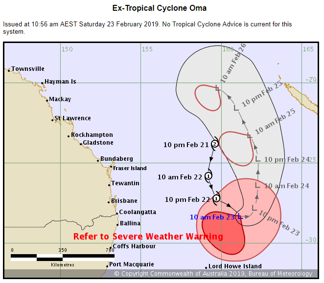

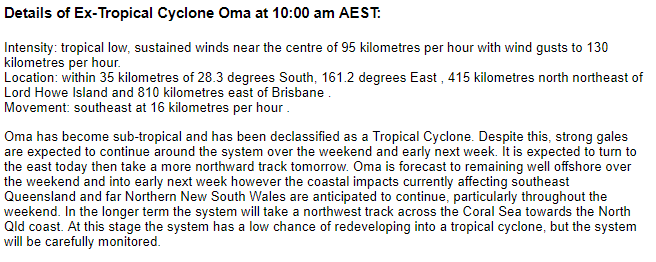
Date: 23/02/2019 12:19:52
From: roughbarked
ID: 1350856
Subject: re: Tropical Cyclone Oma
Michael V said:
Latest advice from the BoM – Oma is now an Ex-TC, but still packing a punch:
They call that a north coast low, those who around the Northern Rivers area.
Date: 23/02/2019 12:32:01
From: Michael V
ID: 1350870
Subject: re: Tropical Cyclone Oma
roughbarked said:
Michael V said:
Latest advice from the BoM – Oma is now an Ex-TC, but still packing a punch:
They call that a north coast low, those who around the Northern Rivers area.
Not really. An east coast low develops as an extra-tropical cyclone. eg:
https://en.wikipedia.org/wiki/Australian_east_coast_low
Date: 23/02/2019 13:12:38
From: Ian
ID: 1350895
Subject: re: Tropical Cyclone Oma
Michael V said:
roughbarked said:
Michael V said:
Latest advice from the BoM – Oma is now an Ex-TC, but still packing a punch:
They call that a north coast low, those who around the Northern Rivers area.
Not really. An east coast low develops as an extra-tropical cyclone. eg:
https://en.wikipedia.org/wiki/Australian_east_coast_low
Yeah. Ex TC Oma is being now being referred to as a subtropical low.
Date: 23/02/2019 18:04:16
From: Divine Angel
ID: 1351050
Subject: re: Tropical Cyclone Oma
Date: 24/02/2019 12:03:56
From: Ian
ID: 1351241
Subject: re: Tropical Cyclone Oma
Saturday:
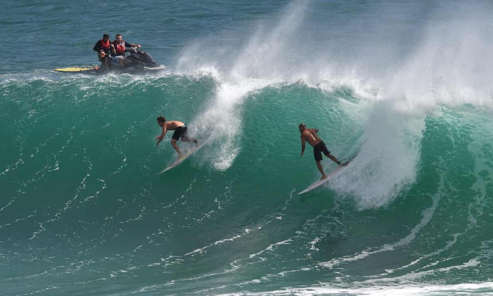
All Gold Coast beaches remained closed for swimming on Saturday, but the big waves lured surfers to take to the water in droves.
Mooloolaba received an offshore swell of up to 13 metres on Friday, and Coastalwatch crowed over a video of Kirra Beach showing Mick Fanning, Joel Parkinson, Mitch Parkinson and “many more core lords getting mega slotted”.
Between Noosa and Mooloolaba, lifesavers rescued 43 surfers on Thursday, the ABC reported.
—
Today:
The system, which has been downgraded from a category two to a sub-tropical low, is currently 700 kilometres east of Brisbane.
A warning remains in place from Fraser Island to the New South Wales border for damaging winds, abnormally high tides, and dangerous surf.
All beaches on the Gold Coast were closed on Saturday due to the wild conditions, while some of the more protected beaches on the Sunshine Coast are open.
A rescue helicopter pulled a man from the surf on the Gold Coast after an incident with a jet ski.
Eight people were also pulled from the water during dawn patrols this morning.
Lifesavers said an overseas tourist was almost swept away while taking photos in ankle-deep water on a beach.
—-
Amazing no one been drowned.
Date: 24/02/2019 12:06:29
From: buffy
ID: 1351244
Subject: re: Tropical Cyclone Oma
Ian said:
Saturday:
All Gold Coast beaches remained closed for swimming on Saturday, but the big waves lured surfers to take to the water in droves.
Mooloolaba received an offshore swell of up to 13 metres on Friday, and Coastalwatch crowed over a video of Kirra Beach showing Mick Fanning, Joel Parkinson, Mitch Parkinson and “many more core lords getting mega slotted”.
Between Noosa and Mooloolaba, lifesavers rescued 43 surfers on Thursday, the ABC reported.
—
Today:
The system, which has been downgraded from a category two to a sub-tropical low, is currently 700 kilometres east of Brisbane.
A warning remains in place from Fraser Island to the New South Wales border for damaging winds, abnormally high tides, and dangerous surf.
All beaches on the Gold Coast were closed on Saturday due to the wild conditions, while some of the more protected beaches on the Sunshine Coast are open.
A rescue helicopter pulled a man from the surf on the Gold Coast after an incident with a jet ski.
Eight people were also pulled from the water during dawn patrols this morning.
Lifesavers said an overseas tourist was almost swept away while taking photos in ankle-deep water on a beach.
—-
Amazing no one been drowned.
Ankle deep? Do they mean a rogue wave got him? (Which would not be ankle deep and is very very scary)
Date: 24/02/2019 12:15:52
From: Ian
ID: 1351248
Subject: re: Tropical Cyclone Oma
buffy said:
Ian said:
Saturday:
All Gold Coast beaches remained closed for swimming on Saturday, but the big waves lured surfers to take to the water in droves.
Mooloolaba received an offshore swell of up to 13 metres on Friday, and Coastalwatch crowed over a video of Kirra Beach showing Mick Fanning, Joel Parkinson, Mitch Parkinson and “many more core lords getting mega slotted”.
Between Noosa and Mooloolaba, lifesavers rescued 43 surfers on Thursday, the ABC reported.
—
Today:
The system, which has been downgraded from a category two to a sub-tropical low, is currently 700 kilometres east of Brisbane.
A warning remains in place from Fraser Island to the New South Wales border for damaging winds, abnormally high tides, and dangerous surf.
All beaches on the Gold Coast were closed on Saturday due to the wild conditions, while some of the more protected beaches on the Sunshine Coast are open.
A rescue helicopter pulled a man from the surf on the Gold Coast after an incident with a jet ski.
Eight people were also pulled from the water during dawn patrols this morning.
Lifesavers said an overseas tourist was almost swept away while taking photos in ankle-deep water on a beach.
—-
Amazing no one been drowned.
Ankle deep? Do they mean a rogue wave got him? (Which would not be ankle deep and is very very scary)
Dunno. Ankle-deep is a common term while half-way-up-the-shin-deep is not.
shrug
Date: 25/02/2019 19:43:05
From: Michael V
ID: 1351867
Subject: re: Tropical Cyclone Oma
https://www.abc.net.au/news/rural/2019-02-25/cudgen-banana-crop-damaged-cyclone-oma/10847430