Date: 20/03/2021 18:01:07
From: mollwollfumble
ID: 1712855
Subject: The wet
Sarah’s mum.
> I think the wet is probably threadworthy.

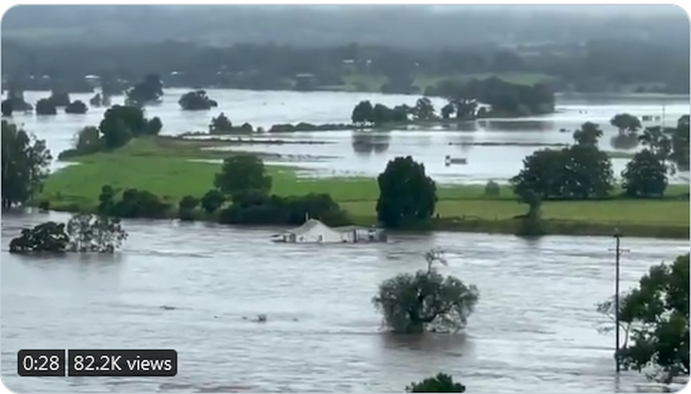
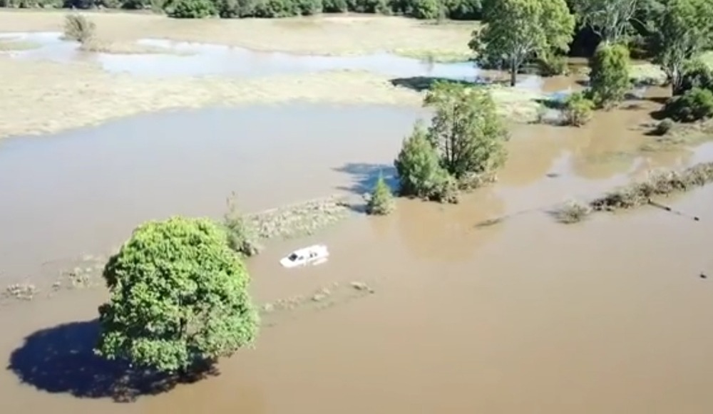
The following image is of house floating down the manning River at Taree.
Sarah’s mum.
> I think the wet is probably threadworthy.
The following image is of house floating down the manning River at Taree.
mollwollfumble said:
Sarah’s mum.> I think the wet is probably threadworthy.
The following image is of house floating down the manning River at Taree.
More on floating house.
https://twitter.com/i/status/1373083065803628547
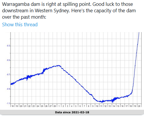
Update on the following image. Warragamba dam began overflowing one hour ago.
Juat having a beer. North coast NSW.
In case you were wondering how many SydHarbs Warragamba Dam is…
“ The dam was created by damming Warragamba River and flooding the Burragorang Valley, and is four times the size of Sydney Harbour.”
https://www.news.com.au/technology/environment/sydneys-warragamba-dam-predicted-to-spill-this-afternoon/news-story/ddb45332c7e05a3509f3afa51a001b97
mollwollfumble said:
mollwollfumble said:
Sarah’s mum.> I think the wet is probably threadworthy.
The following image is of house floating down the manning River at Taree.
More on floating house.
https://twitter.com/i/status/1373083065803628547
Update on the following image. Warragamba dam began overflowing one hour ago.
Juat having a beer. North coast NSW.
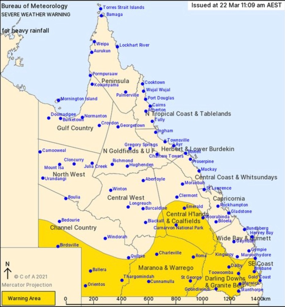
Latest NSW severe weather warning, issued two hours ago.

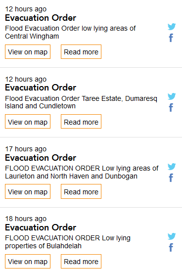
Plenty of evacuation warnings as well. An Evacuation Warning is “prepare yourself for an Evacuation Order”.
Scott Morrison has now made the Defence Force available, should New South Wales request it.
should I be checking in with the nephew in Kyogle?
sarahs mum said:
should I be checking in with the nephew in Kyogle?
Looks okay after looking at last warnings…
The Amazing Tim says there’s nothing to worry about.
sarahs mum said:
sarahs mum said:
should I be checking in with the nephew in Kyogle?
Looks okay after looking at last warnings…
Has anyone heard from Woodie today?
sarahs mum said:
should I be checking in with the nephew in Kyogle?
These are the current warnings for NSW: http://www.bom.gov.au/nsw/warnings/index.shtml
Divine Angel said:
sarahs mum said:
sarahs mum said:
should I be checking in with the nephew in Kyogle?
Looks okay after looking at last warnings…
Has anyone heard from Woodie today?
I haven’t. Do we know where he is?
Divine Angel said:
sarahs mum said:
sarahs mum said:
should I be checking in with the nephew in Kyogle?
Looks okay after looking at last warnings…
Has anyone heard from Woodie today?
No, I told him to go and buy some electricity, fork handles and vitals but never hear anything further.
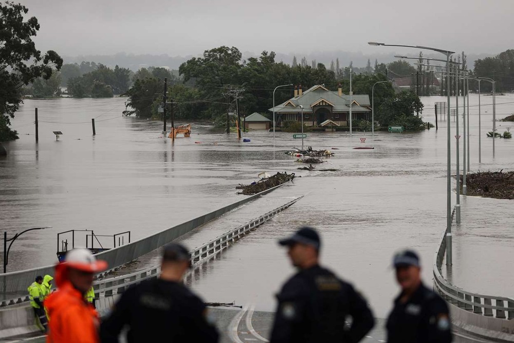
Port Macquarie resident Beverley Quill went to work last night and had no idea of the devastation that awaited her at home.
She was emotional as she waded through the water, retrieving family photographs and moving furniture bought for two properties she intended to rent out.
“It’s devastating, very devastating,” she said.
“I never thought this would happen, it’s never ever happened here. It’s regularly happening down the road but never here. It’s just unbelievable.”
In more bad news for Ms Quill, who had just cancelled her flood insurance, the floodwater was expected to rise again later this evening due to the high tide.
“I was a mess before you guys were here, I’ve been crying all morning … I said to the kids, ‘Don’t leave me, I have the worst anxiety’, it’s really hard,” she said.
Divine Angel said:
sarahs mum said:
sarahs mum said:
should I be checking in with the nephew in Kyogle?
Looks okay after looking at last warnings…
Has anyone heard from Woodie today?
😀😛😵🥴
Woodie said:
Divine Angel said:
sarahs mum said:Looks okay after looking at last warnings…
Has anyone heard from Woodie today?
😀😛😵🥴
Praise the Lord.
Woodie said:
Divine Angel said:
sarahs mum said:Looks okay after looking at last warnings…
Has anyone heard from Woodie today?
😀😛😵🥴
Oh hello. Are those swimming lessons paying off?
sarahs mum said:
sarahs mum said:
should I be checking in with the nephew in Kyogle?
Looks okay after looking at last warnings…
The big wet is down south from here Ms Mum.
Tis a bit wet, but not that wet to flood anything.
This ain’t flood stuff for round here.
mollwollfumble said:
mollwollfumble said:
Sarah’s mum.> I think the wet is probably threadworthy.
The following image is of house floating down the manning River at Taree.
More on floating house.
https://twitter.com/i/status/1373083065803628547
Update on the following image. Warragamba dam began overflowing one hour ago.
Juat having a beer. North coast NSW.
tell you what we really do approve of in all that, is the ISO 8601 done properly
Woodie said:
sarahs mum said:
sarahs mum said:
should I be checking in with the nephew in Kyogle?
Looks okay after looking at last warnings…
The big wet is down south from here Ms Mum.
Tis a bit wet, but not that wet to flood anything.
This ain’t flood stuff for round here.
Thanks Woodie. So it is the niece in Narrabeen that we are worried about.
sarahs mum said:
should I be checking in with the nephew in Kyogle?
I sent a message to a friend that lives in Taree if he and his brother are okay.
Going to Port Macquarie in a few months for my uncle’s birthday. Hotel we’re supposed to be staying at is currently underwater.
Divine Angel said:
Going to Port Macquarie in a few months for my uncle’s birthday. Hotel we’re supposed to be staying at is currently underwater.
oh bother
Met Bureau also predicting storms west of Canberra, and west of Alice Springs.
I wonder whether Lake Eyre might start filling up again.
“Flood Watch for Lasseter, Tanami, Simpson, MacDonnell, Finke, Georgina, Eyre and southern Barkly Inland Rivers,
Severe Weather Warning for parts of Simpson and Lasseter districts.”
It has been quite a wet second half of summer here on the NSW central coast, but this latest rain event is a doozy. It’s bucketing down, and the soil is already saturated. so all the low lying places and roads that usually flood are well and truly doing so now.
The mid north coast looks to be hardest hit so far, but Sydney looks to be in a spot of bother as it keeps on coming for the next 3 days.
Lemons -> Lemonade
Peak Warming Man said:
The Amazing Tim says there’s nothing to worry about.
Climate contrarians delight in highlighting this from Flannery as if it proves a point.
What point?
Ian said:
Peak Warming Man said:
The Amazing Tim says there’s nothing to worry about.
Climate contrarians delight in highlighting this from Flannery as if it proves a point.
What point?
that they don’t know the difference between weather and climate?
ChrispenEvan said:
Ian said:
Peak Warming Man said:
The Amazing Tim says there’s nothing to worry about.
Climate contrarians delight in highlighting this from Flannery as if it proves a point.
What point?
that they don’t know the difference between weather and climate?
14 years ago too. I can understand climate change deniers not changing their views for that long, and longer, but thankfully climate scientists are always updating their models.
Justin: The feds have promised $3bn in aid for the flood stricken areas.
ChrispenEvan said:
Justin: The feds have promised $3bn in aid for the flood stricken areas.
Does anyone have to shake Scott Morrison’s hand on camera?
Neophyte said:
ChrispenEvan said:
Justin: The feds have promised $3bn in aid for the flood stricken areas.
Does anyone have to shake Scott Morrison’s hand on camera?
Only if they don’t want to.
ChrispenEvan said:
Justin: The feds have promised $3bn in aid for the flood stricken areas.
How many meaderies is that?
ChrispenEvan said:
Justin: The feds have promised $3bn in aid for the flood stricken areas.
But it was just a dream, cos when I woke up no monies were to be found…
Michael V said:
Neophyte said:
ChrispenEvan said:
Justin: The feds have promised $3bn in aid for the flood stricken areas.
Does anyone have to shake Scott Morrison’s hand on camera?
Only if they don’t want to.
Hehehehehe
Hey, I’d do it for a mill or two.
sarahs mum said:
ChrispenEvan said:
Justin: The feds have promised $3bn in aid for the flood stricken areas.
How many meaderies is that?
Dunno. Maybe a few.
sibeen said:
Michael V said:
Neophyte said:Does anyone have to shake Scott Morrison’s hand on camera?
Only if they don’t want to.
Hehehehehe
Hey, I’d do it for a mill or two.
I would too.
mollwollfumble said:
Met Bureau also predicting storms west of Canberra, and west of Alice Springs.I wonder whether Lake Eyre might start filling up again.
“Flood Watch for Lasseter, Tanami, Simpson, MacDonnell, Finke, Georgina, Eyre and southern Barkly Inland Rivers,
Severe Weather Warning for parts of Simpson and Lasseter districts.”
Has to rain on the other side of the hills for that.
roughbarked said:
mollwollfumble said:
Met Bureau also predicting storms west of Canberra, and west of Alice Springs.I wonder whether Lake Eyre might start filling up again.
“Flood Watch for Lasseter, Tanami, Simpson, MacDonnell, Finke, Georgina, Eyre and southern Barkly Inland Rivers,
Severe Weather Warning for parts of Simpson and Lasseter districts.”Has to rain on the other side of the hills for that.
Which it is but it does need to rain more than this event to really fill Lake Eyre.
roughbarked said:
roughbarked said:
mollwollfumble said:
Met Bureau also predicting storms west of Canberra, and west of Alice Springs.I wonder whether Lake Eyre might start filling up again.
“Flood Watch for Lasseter, Tanami, Simpson, MacDonnell, Finke, Georgina, Eyre and southern Barkly Inland Rivers,
Severe Weather Warning for parts of Simpson and Lasseter districts.”Has to rain on the other side of the hills for that.
Which it is but it does need to rain more than this event to really fill Lake Eyre.
But then again.. a week of it is a different story.

Warragamba Dam overflows for first time in years amid NSW ‘extreme weather event’
1 hour ago
Sydney’s main water source, Warragamba Dam, has spilled over for the first time since 2016, as rivers in Australia’s largest city swell amid a downpour.
Sydney’s Warragamba Dam spills over during a large rain event. (Twitter: averagejourno)© Provided by ABC NEWS Sydney's Warragamba Dam spills over during a large rain event. (Twitter: averagejourno)
Water began cascading over the dam wall about 4.00pm Saturday, not long after authorities warned much of Greater Sydney to brace for flooding.
NSW’s coastline has been pummelled by a days-long rain event that the Bureau of Meteorology (BoM) has warned will continue into next week.
Several areas have sustained record falls, and while the dam — which is about 70 kilometres from Sydney’s CBD — also spilled over in 2012 and 2013, the last major flooding event was in 1990.
Rising flood waters also led to an evacuation order for Picton, about 40km upstream of the dam.
Authorities are particularly worried about the situation in the nearby Hawkesbury-Nepean valley, which the NSW State Emergency Service (SES) says has one of Australia’s highest flood-danger levels.
A WaterNSW spokesperson warned Nepean, Cataract, Cordeaux and Avon dams were also expected to overflow.
Several parts of the state, particularly on the Mid-North Coast, have already been evacuated amid rising water levels and authorities have warned Sydneysiders to brace for more rain.
The BoM is predicting up to 100mm could fall across Greater Sydney on Sunday and Monday.
The Bureau of Meteorology’s Flood Operations Manager Justin Robinson said authorities were watching the situation closely.
“It’s a very dynamic and evolving flood situation and we could see some very deep and rapid responding rivers with very high levels,” he said.
Premier Gladys Berejiklian said NSW was battling a “deep-seated, extreme weather event”.
A WaterNSW spokesperson said public access to all dams had been blocked until “further notice” as a safety precaution.
“WaterNSW has established a dedicated 24-hour incident management team that is working closely with the Bureau and the NSW State Emergency Service to monitor weather and inflows to dams,” they said.
“WaterNSW will continue to work closely with Sydney Water and NSW Health throughout the rain event, to watch for potential water quality impacts on untreated supply.”
Video: Taree one of the hardest hit regions in recent NSW flooding emergency (Sky News Australia)
monkey skipper said:
Warragamba Dam overflows for first time in years amid NSW ‘extreme weather event’
1 hour agoSydney’s main water source, Warragamba Dam, has spilled over for the first time since 2016, as rivers in Australia’s largest city swell amid a downpour.
Sydney’s Warragamba Dam spills over during a large rain event. (Twitter:
averagejourno)© Provided by ABC NEWS Sydney's Warragamba Dam spills over during a large rain event. (Twitter:averagejourno)
Water began cascading over the dam wall about 4.00pm Saturday, not long after authorities warned much of Greater Sydney to brace for flooding.NSW’s coastline has been pummelled by a days-long rain event that the Bureau of Meteorology (BoM) has warned will continue into next week.
Several areas have sustained record falls, and while the dam — which is about 70 kilometres from Sydney’s CBD — also spilled over in 2012 and 2013, the last major flooding event was in 1990.
Rising flood waters also led to an evacuation order for Picton, about 40km upstream of the dam.
Authorities are particularly worried about the situation in the nearby Hawkesbury-Nepean valley, which the NSW State Emergency Service (SES) says has one of Australia’s highest flood-danger levels.
A WaterNSW spokesperson warned Nepean, Cataract, Cordeaux and Avon dams were also expected to overflow.
Several parts of the state, particularly on the Mid-North Coast, have already been evacuated amid rising water levels and authorities have warned Sydneysiders to brace for more rain.
The BoM is predicting up to 100mm could fall across Greater Sydney on Sunday and Monday.
The Bureau of Meteorology’s Flood Operations Manager Justin Robinson said authorities were watching the situation closely.
“It’s a very dynamic and evolving flood situation and we could see some very deep and rapid responding rivers with very high levels,” he said.
Premier Gladys Berejiklian said NSW was battling a “deep-seated, extreme weather event”.
A WaterNSW spokesperson said public access to all dams had been blocked until “further notice” as a safety precaution.
“WaterNSW has established a dedicated 24-hour incident management team that is working closely with the Bureau and the NSW State Emergency Service to monitor weather and inflows to dams,” they said.
“WaterNSW will continue to work closely with Sydney Water and NSW Health throughout the rain event, to watch for potential water quality impacts on untreated supply.”
Video: Taree one of the hardest hit regions in recent NSW flooding emergency (Sky News Australia)
Mrs rb’s sister lives at Old Bar. Thankfuly her hubby dug some drains. So far only the back yard is under water.
They’ve just got over the busfire that stopped two houses away.
roughbarked said:
Mrs rb’s sister lives at Old Bar. Thankfuly her hubby dug some drains. So far only the back yard is under water.
They’ve just got over the busfire that stopped two houses away.
Bushfire.. before you start asking me about the bus.

Rule 303 said:
Lyle does not deserve air time.
Dark Orange said:
Rule 303 said:
Lyle does not deserve air time.
Lyles golden syrup does though. or rather , pancake time.
Chatting to a friend who lives in Mt Riverview in the Blue Mts. Definitely living up to its name today…
Any chance of pumping some of that into the Murray-Darling?
I’ve said in the past that water in Warragamba and in the Hunter River could be diverted fairly easily into inland rivers.
Gladys Berejiklian says parts of Western Sydney are being hit by a one in 50-year weather event
SCIENCE said:
Gladys Berejiklian says parts of Western Sydney are being hit by a one in 50-year weather event
Lucky to get two in a life time.
SCIENCE said:
Gladys Berejiklian says parts of Western Sydney are being hit by a one in 50-year weather event
What about the other parts?
Woodie said:
SCIENCE said:
Gladys Berejiklian says parts of Western Sydney are being hit by a one in 50-year weather event
What about the other parts?
It hadn’t occurred to me before, though it should have.
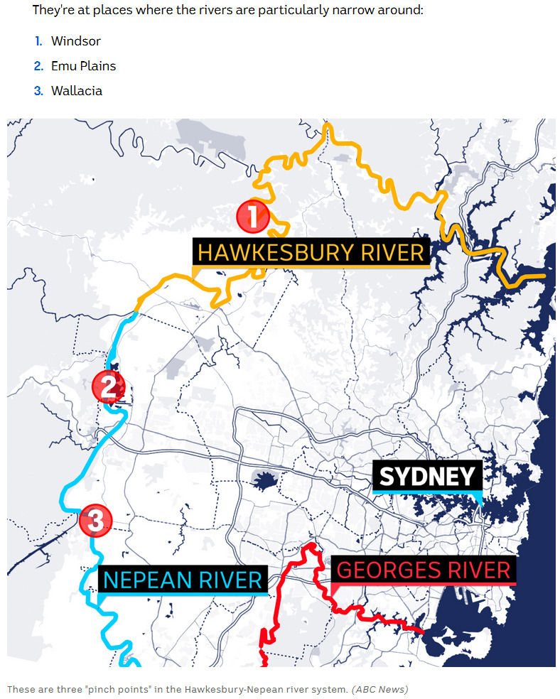
Sydney is startlingly well protected against flooding.
The Hawkesbury-Nepean forms a “ring river” around the city protecting the CBD and inner suburbs against floods.
The water flowing into Sydney Harbour itself is neglibible compared to the amount flowing north.
Leaving only three places where flooding is frequent.
How could great big Sydney Harbour have been formed with so little water flowing through?
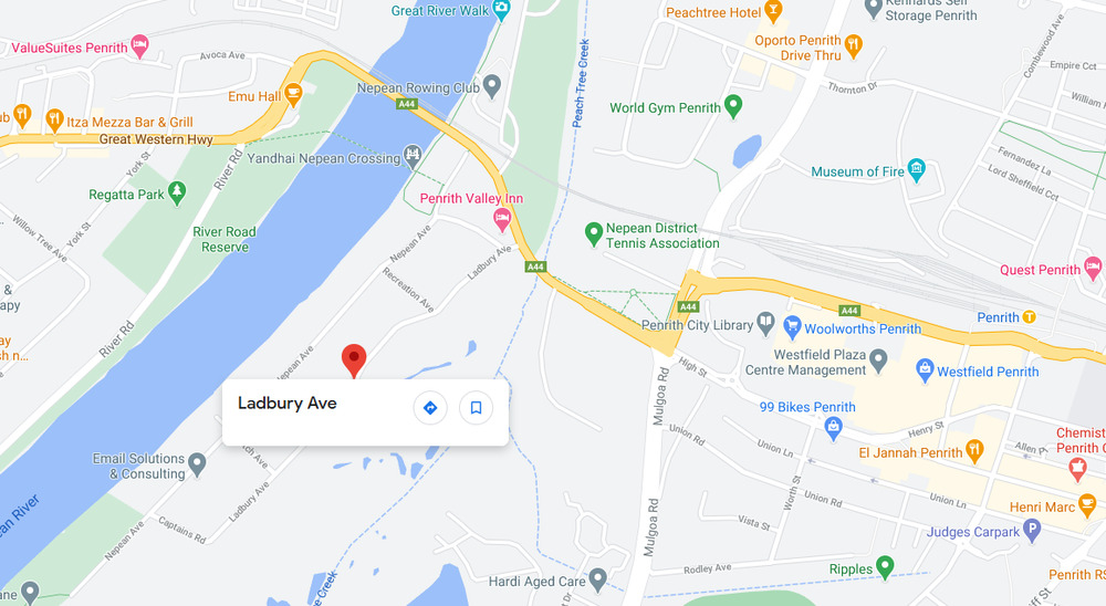
“Major flooding is expected at Penrith, Windsor, Sackville, Lower Portland and Wisemans Ferry from late Sunday,”
Residents in western Penrith are being urged to evacuate, with water entering the rear of properties along Ladbury Avenue.
The SES says the evacuation order is for all properties within the area bounded by the Nepean River, south of the Great Western Highway and west of Peach Tree Creek. This includes Captains Road; Fitch Avenue; Ladbury Avenue; Memorial Avenue; Nepean Avenue; and Recreation Avenue. The evacuation is also for all properties within the area of all the properties in the immediate vicinity of Cables Wake Park, the area bounded by Nepean River, Jamison Road and Peach Tree Creek.
People in the western part of Jamisontown, along the Nepean River, are being ordered to evacuate using the Great Western Highway evacuation route. The evacuation order is for all properties in the area bounded by Jamison Road, Surveyors Creek, Blaikie Road, the rear of the Penrith Homemaker Centre, the Western Motorway and Nepean River. This is due south of Ladbury Ave in the map above.
Regentville residents along the low-lying parts of Mulgoa Creek have been ordered to evacuate by 9pm, with the SES directing people along Martin Street between the creek and the Nepean River to leave via the Mulgoa Road evacuation route. This is further south again.
Good luck getting out via Mulgoa Road. That road is a shocker for congestion even on a normal day.
It could be described here as being a bit damp.
Literally 1.3 km down the road from here.
yeah to be honest we thought the whole “this is a 1-in-N epochs” thing was just a way of excusing N epochs of failure to prepare
mollwollfumble said:
Woodie said:
SCIENCE said:
Gladys Berejiklian says parts of Western Sydney are being hit by a one in 50-year weather event
What about the other parts?
It hadn’t occurred to me before, though it should have.
Sydney is startlingly well protected against flooding.
The Hawkesbury-Nepean forms a “ring river” around the city protecting the CBD and inner suburbs against floods.
The water flowing into Sydney Harbour itself is neglibible compared to the amount flowing north.
Leaving only three places where flooding is frequent.How could great big Sydney Harbour have been formed with so little water flowing through?
It seems to be a historically recent change in the Sydney Harbour watershed that keeps Sydney protected against floods.
The barrier is 63 metres above sea level, which is about 55 m above the river at Windsor.
The barrier is a ridge between Bankstown and Lalor Park.
Mike Nicholls
@Mikenicholls88
·
2h
PS for all the Govt haters, the new bridge was built to replace a very old bridge that was failing
They didn’t destroy any buildings
The traffic has vastly improved
And it was never meant to solve for this level of flooding
No point when other side is entirely under water
sarahs mum said:
25m ago 06:25
Mike Nicholls
@Mikenicholls88
·
2h
PS for all the Govt haters, the new bridge was built to replace a very old bridge that was failingThey didn’t destroy any buildings
The traffic has vastly improved
And it was never meant to solve for this level of flooding
No point when other side is entirely under water
Windsor bridge has officially been swallowed by the Hawkesbury River:
I’m not sure if period undies are suitable for maternity use though.
Divine Angel said:
I’m not sure if period undies are suitable for maternity use though.
Wrong kind of wet, lol @ me
Divine Angel said:
Divine Angel said:
I’m not sure if period undies are suitable for maternity use though.
Wrong kind of wet, lol @ me
Amusing
We’ve only been catching the edges of this thing up until this weekend, but since the rivers have been flowing below minor flood level it hasn’t taken much rain to be back under moderate flood warnings.
The causeway where we get cut off has been under water, out of it again and heading back under well and truly now -
Predictions are for 100 to 200 mm of rain over the next few days. So we could be stuck on our own island for quite a while.
Ian said:
We’ve only been catching the edges of this thing up until this weekend, but since the rivers have been flowing below minor flood level it hasn’t taken much rain to be back under moderate flood warnings.The causeway where we get cut off has been under water, out of it again and heading back under well and truly now -
Predictions are for 100 to 200 mm of rain over the next few days. So we could be stuck on our own island for quite a while.
In compensation, it’s all looking nice and green.
Ian said:
We’ve only been catching the edges of this thing up until this weekend, but since the rivers have been flowing below minor flood level it hasn’t taken much rain to be back under moderate flood warnings.The causeway where we get cut off has been under water, out of it again and heading back under well and truly now -
Predictions are for 100 to 200 mm of rain over the next few days. So we could be stuck on our own island for quite a while.
Genny, flour, fork handles…………
Looks pretty, but that’s a lot moisture being fed this direction from northern WA.
I hope transition is getting some of this.
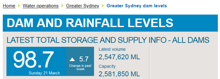
Wivenhoe 423, 143 ML 36.3% 3:35pm 21/03/2021
Hinze 321, 728 ML 103.5% 4:10pm 21/03/2021 Dam is spilling
monkey skipper said:
Wivenhoe 423, 143 ML 36.3% 3:35pm 21/03/2021Hinze 321, 728 ML 103.5% 4:10pm 21/03/2021 Dam is spilling
Musta just fell short of Wivenhoe.
Peak Warming Man said:
I hope transition is getting some of this.
Prolly not. (I can’t remember exactly where he is)
http://www.bom.gov.au/products/IDR271.loop.shtml#skip
Peak Warming Man said:
monkey skipper said:
Wivenhoe 423, 143 ML 36.3% 3:35pm 21/03/2021Hinze 321, 728 ML 103.5% 4:10pm 21/03/2021 Dam is spilling
Musta just fell short of Wivenhoe.
That’s rather a pathetic little rain event.
Ian said:
We’ve only been catching the edges of this thing up until this weekend, but since the rivers have been flowing below minor flood level it hasn’t taken much rain to be back under moderate flood warnings.The causeway where we get cut off has been under water, out of it again and heading back under well and truly now -
Predictions are for 100 to 200 mm of rain over the next few days. So we could be stuck on our own island for quite a while.
I’ve got me gumbies out, Mr Ian. 100% of 60 – 100 moolies for me tomorrow.
Ian said:
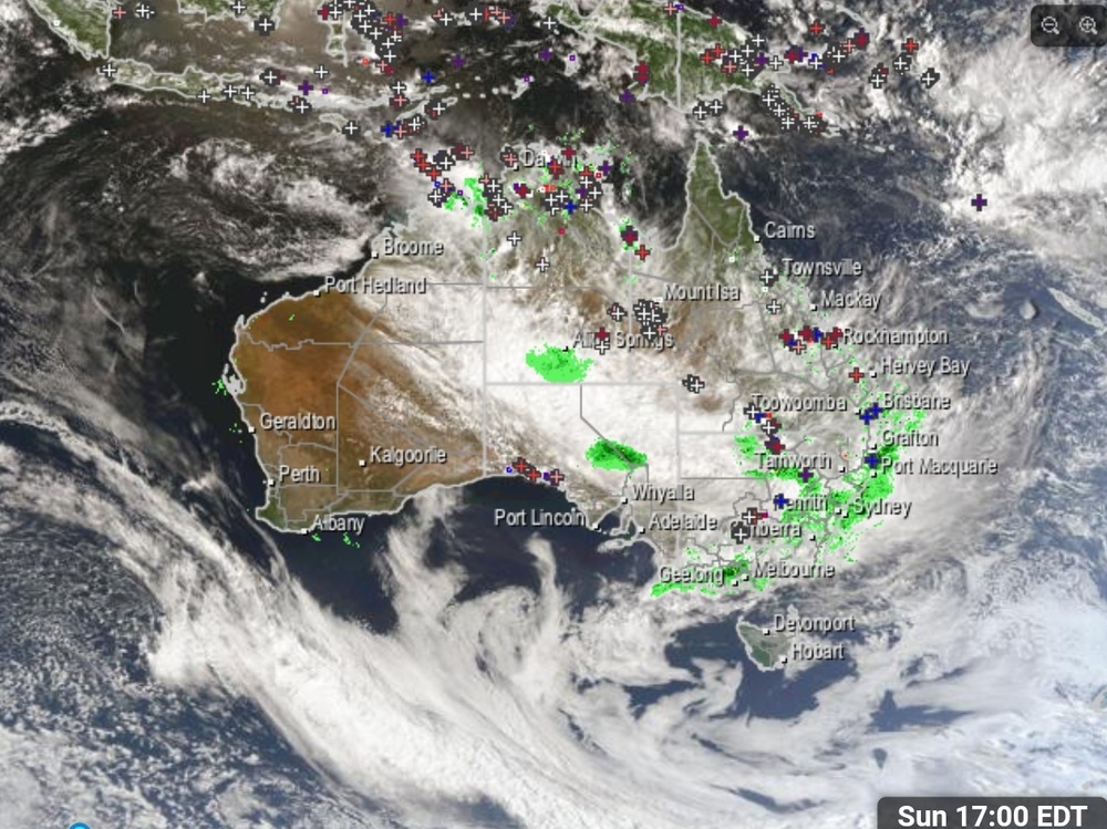
Looks pretty, but that’s a lot moisture being fed this direction from northern WA.
Absolutely!
Another good example of an atmospheric river.
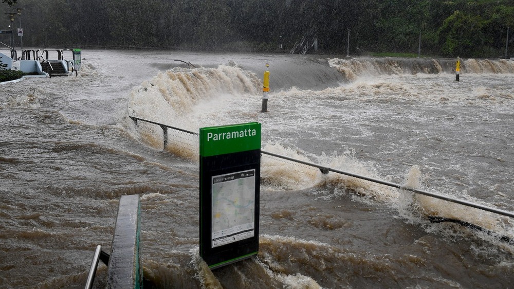
monkey skipper said:
Yeah. I heard it was a bit damp over there.
monkey skipper said:
Yeah, Parra CBD could go under 5 m of water in theory.
party_pants said:
monkey skipper said:
Yeah. I heard it was a bit damp over there.
Moist.
monkey skipper said:
pfffft crossed longer flooded roadways in queensland in my old landie.
ChrispenEvan said:
monkey skipper said:
pfffft crossed longer flooded roadways in queensland in my old landie.
Yep, as long as you hit it at speed with plenty of throttle.
Peak Warming Man said:
ChrispenEvan said:
monkey skipper said:
pfffft crossed longer flooded roadways in queensland in my old landie.
Yep, as long as you hit it at speed with plenty of throttle.
it’s a landrover.
Peak Warming Man said:
ChrispenEvan said:
monkey skipper said:
pfffft crossed longer flooded roadways in queensland in my old landie.
Yep, as long as you hit it at speed with plenty of throttle.
How many Tritons have you gone through now?
SCIENCE said:
Gladys Berejiklian says parts of Western Sydney are being hit by a one in 50-year weather event
Once in a 100 years and once in 50 years is the LNP way of saying this has happened before and will happen again and has nothing to do with climate change. Jones and co will be satisfied.
NSW SES says a number of schools will be advised to close
fkov, do they not think about the negative social and psychological impacts of school closure versus getting a little bit damp, this is just a little drizzle, the economic cost of shutting schools will be unbelievable in 20 years
ChrispenEvan said:
Peak Warming Man said:
ChrispenEvan said:pfffft crossed longer flooded roadways in queensland in my old landie.
Yep, as long as you hit it at speed with plenty of throttle.
it’s a landrover.
LOL
Full throttle, even on the sixes wouldn’t pull the skin off a rice pudding. Except in low-low.
PermeateFree said:
SCIENCE said:
Gladys Berejiklian says parts of Western Sydney are being hit by a one in 50-year weather event
Once in a 100 years and once in 50 years is the LNP way of saying this has happened before and will happen again and has nothing to do with climate change. Jones and co will be satisfied.
Once in a 100 years and once in 50 years is the Civil and Environmental Engineers way of saying this has happened before and will happen again and has nothing to do with climate change.
Corrected.
mollwollfumble said:
PermeateFree said:
SCIENCE said:
Gladys Berejiklian says parts of Western Sydney are being hit by a one in 50-year weather event
Once in a 100 years and once in 50 years is the LNP way of saying this has happened before and will happen again and has nothing to do with climate change. Jones and co will be satisfied.
Once in a 100 years and once in 50 years is the Civil and Environmental Engineers way of saying this has happened before and will happen again and has nothing to do with climate change.
Corrected.
Weather is the result of climate change whereby it becomes more frequent and extreme. When you consider NSW has recently gone though a devastating long drought and then bushfires not known before and now floods of such continued downpour that would rival the wettest climates on this planet.
PermeateFree said:
mollwollfumble said:
PermeateFree said:Once in a 100 years and once in 50 years is the LNP way of saying this has happened before and will happen again and has nothing to do with climate change. Jones and co will be satisfied.
Once in a 100 years and once in 50 years is the Civil and Environmental Engineers way of saying this has happened before and will happen again and has nothing to do with climate change.
Corrected.
Weather is the result of climate change whereby it becomes more frequent and extreme. When you consider NSW has recently gone though a devastating long drought and then bushfires not known before and now floods of such continued downpour that would rival the wettest climates on this planet.
What we are experiencing throughout Australia is a direct result or strong influence of climate change.
PermeateFree said:
PermeateFree said:
mollwollfumble said:Once in a 100 years and once in 50 years is the Civil and Environmental Engineers way of saying this has happened before and will happen again and has nothing to do with climate change.
Corrected.
Weather is the result of climate change whereby it becomes more frequent and extreme. When you consider NSW has recently gone though a devastating long drought and then bushfires not known before and now floods of such continued downpour that would rival the wettest climates on this planet.
What we are experiencing throughout Australia is a direct result or strong influence of climate change.
As it turns out, environmental engineers rate their career happiness 2.9 out of 5 stars which puts them in the bottom 23% of careers. :)))
we tend to agree with PermeateFree here that the use of those descriptors is just a way of weaseling out of taking responsibility but yeah
mollwollfumble said:
PermeateFree said:
SCIENCE said:
Gladys Berejiklian says parts of Western Sydney are being hit by a one in 50-year weather event
Once in a 100 years and once in 50 years is the LNP way of saying this has happened before and will happen again and has nothing to do with climate change. Jones and co will be satisfied.
Once in a 100 years and once in 50 years is the Civil and Environmental Engineers way of saying this has happened before and will happen again and has nothing to do with climate change.
Corrected.
Still no reason to build major towns in flood prone positions.
The real reason is that people have always been too lazy to carry a bucket of water uphill.
mollwollfumble said:
PermeateFree said:
SCIENCE said:
Gladys Berejiklian says parts of Western Sydney are being hit by a one in 50-year weather event
Once in a 100 years and once in 50 years is the LNP way of saying this has happened before and will happen again and has nothing to do with climate change. Jones and co will be satisfied.
Once in a 100 years and once in 50 years is the Civil and Environmental Engineers way of saying this has happened before and will happen again and has nothing to do with climate change.
Corrected.
I know you like to be a bit of a contrarian occasionally, but there are times when spouting absolute crap is just spouting absolute crap.
Adjusting estimated recurrence intervals for the likely effects of climate change, and carrying out the necessary resulting flood protection/mitigation works, is something that obviously needs to be done, but as far as I can see has barely started.
Polesaw: coleslaw made with fermented cabbage, popular in Poland.
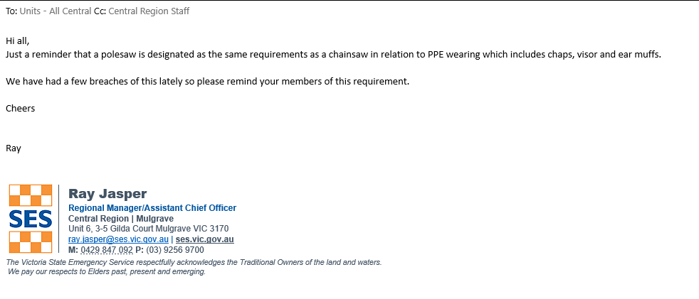
Oops. Oh dear, I’ve just shared an e-mail from a bureaucrat insisting that we are required to wear PPE to protect against an injury that cannot possibly occur. By which I mean it’s literally impossible to injure ones legs (and thus need chainsaw chaps) using a polesaw. Totally unintentional. Mea culpa.
The Rev Dodgson said:
mollwollfumble said:
PermeateFree said:Once in a 100 years and once in 50 years is the LNP way of saying this has happened before and will happen again and has nothing to do with climate change. Jones and co will be satisfied.
Once in a 100 years and once in 50 years is the Civil and Environmental Engineers way of saying this has happened before and will happen again and has nothing to do with climate change.
Corrected.
I know you like to be a bit of a contrarian occasionally, but there are times when spouting absolute crap is just spouting absolute crap.
Adjusting estimated recurrence intervals for the likely effects of climate change, and carrying out the necessary resulting flood protection/mitigation works, is something that obviously needs to be done, but as far as I can see has barely started.
Isn’t it interesting how something can not-happen for 99 years, and nobody thinks even once about it, and then on the 100th year suddenly it happens and everyone already knew it was a once-in-100-year event¿ You’re right, it isn’t…
So we have our neat little situation here, after 99 years,
for some people every year that goes by they’re more and more nervous, it’s overdue, it could all come crashing down like a 2021 phlood or go up in phlames like a 2019 phyre or just wipe everyone out like a mild 2020 phlue,
but for other people it’s just another year that these things didn’t happen and therefore time to revise down the probabilities that they will happen, in the 99th year the 1 in 100 hasn’t happened yet so it’s probably a 1 in 101.
Who’s right¿
Rule 303 said:
Oops. Oh dear, I’ve just shared an e-mail from a bureaucrat insisting that we are required to wear PPE to protect against an injury that cannot possibly occur. By which I mean it’s literally impossible to injure ones legs (and thus need chainsaw chaps) using a polesaw. Totally unintentional. Mea culpa.
Oh, I don’t know about that…I’m fairly certain there is a person in this town who could have a damn good try…(no, not Mr buffy)
buffy said:
Rule 303 said:
Oops. Oh dear, I’ve just shared an e-mail from a bureaucrat insisting that we are required to wear PPE to protect against an injury that cannot possibly occur. By which I mean it’s literally impossible to injure ones legs (and thus need chainsaw chaps) using a polesaw. Totally unintentional. Mea culpa.
Oh, I don’t know about that…I’m fairly certain there is a person in this town who could have a damn good try…(no, not Mr buffy)
I imagine that Sceptic Pete has become a bit damp over the last few days.
buffy said:
Rule 303 said:
Oops. Oh dear, I’ve just shared an e-mail from a bureaucrat insisting that we are required to wear PPE to protect against an injury that cannot possibly occur. By which I mean it’s literally impossible to injure ones legs (and thus need chainsaw chaps) using a polesaw. Totally unintentional. Mea culpa.
Oh, I don’t know about that…I’m fairly certain there is a person in this town who could have a damn good try…(no, not Mr buffy)
I did scientific tall-guy testing of the hypothesis. A 6’5” tall subject was unable to operate the throttle while lifting the nose of the cutter bar off the ground with the saw in a vertical position.
Rule 303 said:
buffy said:
Rule 303 said:
Oops. Oh dear, I’ve just shared an e-mail from a bureaucrat insisting that we are required to wear PPE to protect against an injury that cannot possibly occur. By which I mean it’s literally impossible to injure ones legs (and thus need chainsaw chaps) using a polesaw. Totally unintentional. Mea culpa.
Oh, I don’t know about that…I’m fairly certain there is a person in this town who could have a damn good try…(no, not Mr buffy)
I did scientific tall-guy testing of the hypothesis. A 6’5” tall subject was unable to operate the throttle while lifting the nose of the cutter bar off the ground with the saw in a vertical position.
Pfft, you should have tried with D. You’ll never get anywhere with sensible people…
buffy said:
Rule 303 said:
buffy said:Oh, I don’t know about that…I’m fairly certain there is a person in this town who could have a damn good try…(no, not Mr buffy)
I did scientific tall-guy testing of the hypothesis. A 6’5” tall subject was unable to operate the throttle while lifting the nose of the cutter bar off the ground with the saw in a vertical position.
Pfft, you should have tried with D. You’ll never get anywhere with sensible people…
I guess you could… Cable-tie the throttle on and walk down to where the bar is? Rev it to full speed and then drop it and jump?
Rule 303 said:
buffy said:
Rule 303 said:I did scientific tall-guy testing of the hypothesis. A 6’5” tall subject was unable to operate the throttle while lifting the nose of the cutter bar off the ground with the saw in a vertical position.
Pfft, you should have tried with D. You’ll never get anywhere with sensible people…
I guess you could… Cable-tie the throttle on and walk down to where the bar is? Rev it to full speed and then drop it and jump?
You scare me. ;)
Rule 303 said:
buffy said:
Rule 303 said:I did scientific tall-guy testing of the hypothesis. A 6’5” tall subject was unable to operate the throttle while lifting the nose of the cutter bar off the ground with the saw in a vertical position.
Pfft, you should have tried with D. You’ll never get anywhere with sensible people…
I guess you could… Cable-tie the throttle on and walk down to where the bar is? Rev it to full speed and then drop it and jump?
Stop it! (Yes, something like that…)

NSW Incident Alerts
45 mins ·
⚠️ 🌧 💨 48 HOURS OF SEVERE WEATHER TO COME
- Bureau of Meteorology
- 12:20PM, Monday 22nd March
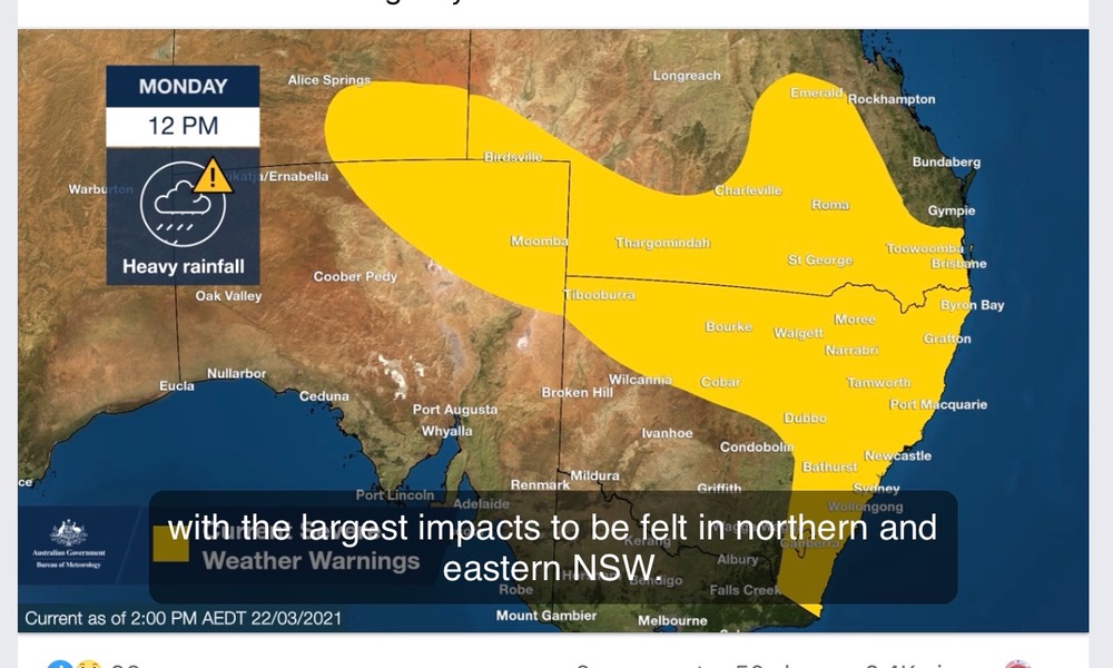
A strong high pressure system over the southern Tasman Sea continues to drive widespread and persistent rain onto the New South Wales coast. This is expected to continue today, particularly about the Mid North Coast and Northern Rivers.
Meanwhile, a low pressure trough in the state’s west is deepening, bringing rain areas to the northern inland today.
In this area, heavy rain is possible from the morning, becoming more likely in the afternoon and evening, extending to areas of the southeast over Tuesday. On Tuesday, as the trough reaches the Tasman Sea, a low pressure system may form, bringing increased rainfall, strong winds, damaging surf and abnormally high tides to the east and south.
Most areas of New South Wales will see a clearing trend early Wednesday as a drier airmass moves into the region.
EASTERN AREAS:
🌧 HEAVY RAIN, likely leading to FLASH FLOODING, presents a SERIOUS RISK to the Northern Rivers and Mid North Coast today and on Tuesday. Some risk remains for the Hunter and Central Tablelands districts during this period, particularly given the saturated nature of catchments. Due to extensive flooding across the east, localised moderate rainfall may also bring the risk of FLASH FLOODING. In some areas, heavy rain and flooding may be LIFE-THREATENING.
💨 DAMAGING WINDS, averaging 60 to 70 km/h with peak gusts in excess of 90 km/h are possible along the coastal fringe south of Seal Rocks from Tuesday morning.
🌊 VERY HEAVY SURF, which may lead to localised damage and coastal erosion is likely for areas of the coastline south of Moruya from Tuesday afternoon, as strong northeasterly winds build over the waters. Beach conditions in these areas could be dangerous and people should stay well away from the surf and surf exposed areas.
🌊 ABNORMALLY HIGH TIDES which may cause sea water flooding of low lying areas south of Moruya are also possible. Water levels could exceed the highest tide of the year during Tuesday morning’s high tide as a storm surge moves into coastal areas.
Roads in some areas are cut off by water, and there is an increased risk of landslips during this period. In addition, super-saturated soils along areas of the east bring an increased risk of moderately gusty winds toppling trees.
River catchments in this area are wet, bringing an enhanced risk of renewed RIVERINE FLOODING. Numerous flood watches and warnings are current. Latest updates at http://www.bom.gov.au/nsw/warnings/.
WESTERN AREAS:
🌧 HEAVY RAIN, likely leading to FLASH FLOODING, is forecast to develop in parts of the Upper Western, Central Tablelands, North West Slopes and Plains, and Central West Slopes and Plains forecast districts from this morning, becoming more likely in the afternoon and evening. Heavy rainfall will then extend to areas of the ACT, South Coast, Snowy Mountains and Northern Tablelands during Tuesday. There is an enhanced risk with any thunderstorm activity.
Widespread rainfall may lead to RIVERINE FLOODING, and a Flood Watch is current for catchments on the western slopes.
Locations which may be affected include #Lismore, #Grafton, #CoffsHarbour, #PortMacquarie, #Taree, #Newcastle, #Sydney, #Wollongong, #Nowra, #BatemansBay, #Armidale, #Orange, #Canberra, #Goulburn, #Tamworth, #Moree, #Dubbo, #Tibooburra, #Cobar and #Bourke.
▪️Register now to receive SMS alerts when severe weather may impact you. www.nswincidentalerts.com
▪️www.bom.gov.au www.ses.nsw.gov.au
▪️For Emergency help, call NSW SES on 132 500.
Rule 303 said:
buffy said:
Rule 303 said:I did scientific tall-guy testing of the hypothesis. A 6’5” tall subject was unable to operate the throttle while lifting the nose of the cutter bar off the ground with the saw in a vertical position.
Pfft, you should have tried with D. You’ll never get anywhere with sensible people…
I guess you could… Cable-tie the throttle on and walk down to where the bar is? Rev it to full speed and then drop it and jump?
Amazing what you can do with rubber bands.
sarahs mum said:
NSW Incident Alerts
45 mins ·
⚠️ 🌧 💨 48 HOURS OF SEVERE WEATHER TO COME
- Bureau of Meteorology
- 12:20PM, Monday 22nd March
A strong high pressure system over the southern Tasman Sea continues to drive widespread and persistent rain onto the New South Wales coast. This is expected to continue today, particularly about the Mid North Coast and Northern Rivers.
Meanwhile, a low pressure trough in the state’s west is deepening, bringing rain areas to the northern inland today.
In this area, heavy rain is possible from the morning, becoming more likely in the afternoon and evening, extending to areas of the southeast over Tuesday. On Tuesday, as the trough reaches the Tasman Sea, a low pressure system may form, bringing increased rainfall, strong winds, damaging surf and abnormally high tides to the east and south.
Most areas of New South Wales will see a clearing trend early Wednesday as a drier airmass moves into the region.
EASTERN AREAS:
🌧 HEAVY RAIN, likely leading to FLASH FLOODING, presents a SERIOUS RISK to the Northern Rivers and Mid North Coast today and on Tuesday. Some risk remains for the Hunter and Central Tablelands districts during this period, particularly given the saturated nature of catchments. Due to extensive flooding across the east, localised moderate rainfall may also bring the risk of FLASH FLOODING. In some areas, heavy rain and flooding may be LIFE-THREATENING.
💨 DAMAGING WINDS, averaging 60 to 70 km/h with peak gusts in excess of 90 km/h are possible along the coastal fringe south of Seal Rocks from Tuesday morning.
🌊 VERY HEAVY SURF, which may lead to localised damage and coastal erosion is likely for areas of the coastline south of Moruya from Tuesday afternoon, as strong northeasterly winds build over the waters. Beach conditions in these areas could be dangerous and people should stay well away from the surf and surf exposed areas.
🌊 ABNORMALLY HIGH TIDES which may cause sea water flooding of low lying areas south of Moruya are also possible. Water levels could exceed the highest tide of the year during Tuesday morning’s high tide as a storm surge moves into coastal areas.
Roads in some areas are cut off by water, and there is an increased risk of landslips during this period. In addition, super-saturated soils along areas of the east bring an increased risk of moderately gusty winds toppling trees.
River catchments in this area are wet, bringing an enhanced risk of renewed RIVERINE FLOODING. Numerous flood watches and warnings are current. Latest updates at http://www.bom.gov.au/nsw/warnings/.
WESTERN AREAS:
🌧 HEAVY RAIN, likely leading to FLASH FLOODING, is forecast to develop in parts of the Upper Western, Central Tablelands, North West Slopes and Plains, and Central West Slopes and Plains forecast districts from this morning, becoming more likely in the afternoon and evening. Heavy rainfall will then extend to areas of the ACT, South Coast, Snowy Mountains and Northern Tablelands during Tuesday. There is an enhanced risk with any thunderstorm activity.
Widespread rainfall may lead to RIVERINE FLOODING, and a Flood Watch is current for catchments on the western slopes.
Locations which may be affected include #Lismore, #Grafton, #CoffsHarbour, #PortMacquarie, #Taree, #Newcastle, #Sydney, #Wollongong, #Nowra, #BatemansBay, #Armidale, #Orange, #Canberra, #Goulburn, #Tamworth, #Moree, #Dubbo, #Tibooburra, #Cobar and #Bourke.
▪️Register now to receive SMS alerts when severe weather may impact you. www.nswincidentalerts.com
▪️www.bom.gov.au www.ses.nsw.gov.au
▪️For Emergency help, call NSW SES on 132 500.
That’s a lotta weather there, Ms Mum.
Woodie said:
Rule 303 said:
buffy said:Pfft, you should have tried with D. You’ll never get anywhere with sensible people…
I guess you could… Cable-tie the throttle on and walk down to where the bar is? Rev it to full speed and then drop it and jump?
Amazing what you can do with rubber bands.
We’ll will definitely want chaps if you’re bringing out the rubbers.
sarahs mum said:
NSW Incident Alerts
45 mins ·
⚠️ 🌧 💨 48 HOURS OF SEVERE WEATHER TO COME
- Bureau of Meteorology
- 12:20PM, Monday 22nd March
A strong high pressure system over the southern Tasman Sea continues to drive widespread and persistent rain onto the New South Wales coast. This is expected to continue today, particularly about the Mid North Coast and Northern Rivers.
Meanwhile, a low pressure trough in the state’s west is deepening, bringing rain areas to the northern inland today.
In this area, heavy rain is possible from the morning, becoming more likely in the afternoon and evening, extending to areas of the southeast over Tuesday. On Tuesday, as the trough reaches the Tasman Sea, a low pressure system may form, bringing increased rainfall, strong winds, damaging surf and abnormally high tides to the east and south.
Most areas of New South Wales will see a clearing trend early Wednesday as a drier airmass moves into the region.
EASTERN AREAS:
🌧 HEAVY RAIN, likely leading to FLASH FLOODING, presents a SERIOUS RISK to the Northern Rivers and Mid North Coast today and on Tuesday. Some risk remains for the Hunter and Central Tablelands districts during this period, particularly given the saturated nature of catchments. Due to extensive flooding across the east, localised moderate rainfall may also bring the risk of FLASH FLOODING. In some areas, heavy rain and flooding may be LIFE-THREATENING.
💨 DAMAGING WINDS, averaging 60 to 70 km/h with peak gusts in excess of 90 km/h are possible along the coastal fringe south of Seal Rocks from Tuesday morning.
🌊 VERY HEAVY SURF, which may lead to localised damage and coastal erosion is likely for areas of the coastline south of Moruya from Tuesday afternoon, as strong northeasterly winds build over the waters. Beach conditions in these areas could be dangerous and people should stay well away from the surf and surf exposed areas.
🌊 ABNORMALLY HIGH TIDES which may cause sea water flooding of low lying areas south of Moruya are also possible. Water levels could exceed the highest tide of the year during Tuesday morning’s high tide as a storm surge moves into coastal areas.
Roads in some areas are cut off by water, and there is an increased risk of landslips during this period. In addition, super-saturated soils along areas of the east bring an increased risk of moderately gusty winds toppling trees.
River catchments in this area are wet, bringing an enhanced risk of renewed RIVERINE FLOODING. Numerous flood watches and warnings are current. Latest updates at http://www.bom.gov.au/nsw/warnings/.
WESTERN AREAS:
🌧 HEAVY RAIN, likely leading to FLASH FLOODING, is forecast to develop in parts of the Upper Western, Central Tablelands, North West Slopes and Plains, and Central West Slopes and Plains forecast districts from this morning, becoming more likely in the afternoon and evening. Heavy rainfall will then extend to areas of the ACT, South Coast, Snowy Mountains and Northern Tablelands during Tuesday. There is an enhanced risk with any thunderstorm activity.
Widespread rainfall may lead to RIVERINE FLOODING, and a Flood Watch is current for catchments on the western slopes.
Locations which may be affected include #Lismore, #Grafton, #CoffsHarbour, #PortMacquarie, #Taree, #Newcastle, #Sydney, #Wollongong, #Nowra, #BatemansBay, #Armidale, #Orange, #Canberra, #Goulburn, #Tamworth, #Moree, #Dubbo, #Tibooburra, #Cobar and #Bourke.
▪️Register now to receive SMS alerts when severe weather may impact you. www.nswincidentalerts.com
▪️www.bom.gov.au www.ses.nsw.gov.au
▪️For Emergency help, call NSW SES on 132 500.
Jazus! When you’ve got a weather warning that includes Nowra and Bourke you’ve got trouble.
Peak Warming Man said:
sarahs mum said:
NSW Incident Alerts
45 mins ·
⚠️ 🌧 💨 48 HOURS OF SEVERE WEATHER TO COME
- Bureau of Meteorology
- 12:20PM, Monday 22nd March
A strong high pressure system over the southern Tasman Sea continues to drive widespread and persistent rain onto the New South Wales coast. This is expected to continue today, particularly about the Mid North Coast and Northern Rivers.
Meanwhile, a low pressure trough in the state’s west is deepening, bringing rain areas to the northern inland today.
In this area, heavy rain is possible from the morning, becoming more likely in the afternoon and evening, extending to areas of the southeast over Tuesday. On Tuesday, as the trough reaches the Tasman Sea, a low pressure system may form, bringing increased rainfall, strong winds, damaging surf and abnormally high tides to the east and south.
Most areas of New South Wales will see a clearing trend early Wednesday as a drier airmass moves into the region.
EASTERN AREAS:
🌧 HEAVY RAIN, likely leading to FLASH FLOODING, presents a SERIOUS RISK to the Northern Rivers and Mid North Coast today and on Tuesday. Some risk remains for the Hunter and Central Tablelands districts during this period, particularly given the saturated nature of catchments. Due to extensive flooding across the east, localised moderate rainfall may also bring the risk of FLASH FLOODING. In some areas, heavy rain and flooding may be LIFE-THREATENING.
💨 DAMAGING WINDS, averaging 60 to 70 km/h with peak gusts in excess of 90 km/h are possible along the coastal fringe south of Seal Rocks from Tuesday morning.
🌊 VERY HEAVY SURF, which may lead to localised damage and coastal erosion is likely for areas of the coastline south of Moruya from Tuesday afternoon, as strong northeasterly winds build over the waters. Beach conditions in these areas could be dangerous and people should stay well away from the surf and surf exposed areas.
🌊 ABNORMALLY HIGH TIDES which may cause sea water flooding of low lying areas south of Moruya are also possible. Water levels could exceed the highest tide of the year during Tuesday morning’s high tide as a storm surge moves into coastal areas.
Roads in some areas are cut off by water, and there is an increased risk of landslips during this period. In addition, super-saturated soils along areas of the east bring an increased risk of moderately gusty winds toppling trees.
River catchments in this area are wet, bringing an enhanced risk of renewed RIVERINE FLOODING. Numerous flood watches and warnings are current. Latest updates at http://www.bom.gov.au/nsw/warnings/.
WESTERN AREAS:
🌧 HEAVY RAIN, likely leading to FLASH FLOODING, is forecast to develop in parts of the Upper Western, Central Tablelands, North West Slopes and Plains, and Central West Slopes and Plains forecast districts from this morning, becoming more likely in the afternoon and evening. Heavy rainfall will then extend to areas of the ACT, South Coast, Snowy Mountains and Northern Tablelands during Tuesday. There is an enhanced risk with any thunderstorm activity.
Widespread rainfall may lead to RIVERINE FLOODING, and a Flood Watch is current for catchments on the western slopes.
Locations which may be affected include #Lismore, #Grafton, #CoffsHarbour, #PortMacquarie, #Taree, #Newcastle, #Sydney, #Wollongong, #Nowra, #BatemansBay, #Armidale, #Orange, #Canberra, #Goulburn, #Tamworth, #Moree, #Dubbo, #Tibooburra, #Cobar and #Bourke.
▪️Register now to receive SMS alerts when severe weather may impact you. www.nswincidentalerts.com
▪️www.bom.gov.au www.ses.nsw.gov.au
▪️For Emergency help, call NSW SES on 132 500.
Jazus! When you’ve got a weather warning that includes Nowra and Bourke you’ve got trouble.
Even out the back a’ Bourke too.
buffy said:
Rule 303 said:
Oops. Oh dear, I’ve just shared an e-mail from a bureaucrat insisting that we are required to wear PPE to protect against an injury that cannot possibly occur. By which I mean it’s literally impossible to injure ones legs (and thus need chainsaw chaps) using a polesaw. Totally unintentional. Mea culpa.
Oh, I don’t know about that…I’m fairly certain there is a person in this town who could have a damn good try…(no, not Mr buffy)
thing is did Ray come up with these requirements? Maybe he thinks they are not applicable too but has to follow the guidelines of informing those down the ladder. If he didn’t and an accident did happen imagine the shit and the fan. Best option, rather than shaming, is to try to get these guidelines altered. Yeah, I know that might be next to impossible but shaming won’t do it either. at one is more positive than the other.
All the way up to the Sunshine Coast and out past the Qld/NSW/SA border too.
Couple of pics from BOM on fb
(From 9.00am yesterday to a couple of hours ago we had ….. 2mm …….)
buffy said:
(From 9.00am yesterday to a couple of hours ago we had ….. 2mm …….)
Braggart.
Divine Angel said:
Couple of pics from BOM on fb
Looks like Mallacoota is in for a drenching.
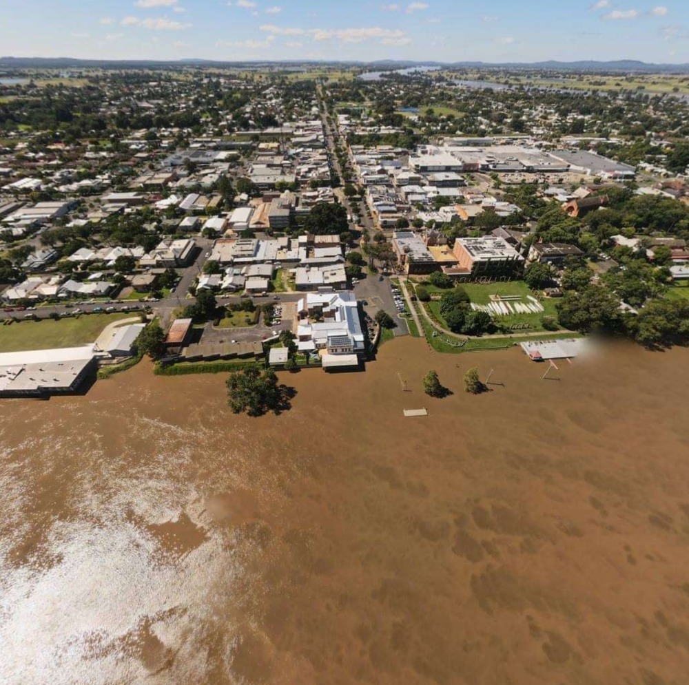
With sections of the construction site for Sydney’s Parramatta Powerhouse now submerged by flood water, debate has reignited over the suitability of the $915m project’s riverside location.
An independent Parramatta-based flood management consultant, Steven Molino, told Guardian Australia on Monday that events over the past three days should serve as a wake-up call to the New South Wales government.
NSW flooding: disaster zones declared as 18,000 people evacuated in Sydney and mid-north coast
Read more
“The lower parts of the Parramatta Powerhouse will go underwater … that’s just the nature of the riverside location that has been chosen,” he said. “Now it’s up to the state government to decide whether the risk is worth it – and that risk assessment has not been done.”
The Parramatta River broke its banks on Saturday, flooding the path that runs alongside the museum site and inundating the ground floor of a four-level car park slated for demolition as part of the museum’s construction.
It is the second time in just over a year that the proposed site for the museum has been inundated by a swollen Parramatta River during heavy rainfall.
Molino, who gave evidence at the state government’s inquiry into museums last month, said the government’s much-vaunted one-in-1,000 year scenario meant that in the building’s predicted 100-year lifespan, there was a 10% chance that water was going to get into the building.
“If it was an office building with just office furniture and carpets and everything, it wouldn’t matter – if it gets flooded you go down to Carpet Court and buy new carpet, you go down to Officeworks and buy new furniture – it’s all easily replaced,” he said.
“But the information we have at present suggests that the electrical power supply will go out and the generators won’t operate the air conditioning system. So you’ll have a spike in humidity … and if you’ve got items in the collection made from paper, textiles, and even wood and some metals, collection will deteriorate, be possibly irreparably damaged or even lost.
“Now the decision might be made that the probability of this occurring is an acceptable risk, but no one has gone through that process.”
The Infrastructure NSW-delivered project must go through such a risk assessment, but only after construction has been completed and the project reaches its occupation stage.
A museum specialist and member of the Powerhouse Museum Alliance, Kylie Winkworth, said Molino’s concerns were valid.
Advertisement
“It is odd that the condition of consent to investigate the risk of flood damages to the collection is conditioned at the occupation stage instead of prior to construction, when it should in fact have been part of the EIS ,” she said.
“The NSW Government will spend $1bn and not know if the building is fit for purpose and safe for collections until it is ready for occupation.
“This is quite bizarre – and reckless.”
https://www.theguardian.com/culture/2021/mar/22/monstrosity-on-stilts-powerhouse-museum-under-fire-after-parramatta-river-floods
—throw down your gun.
sarahs mum said:
With sections of the construction site for Sydney’s Parramatta Powerhouse now submerged by flood water, debate has reignited over the suitability of the $915m project’s riverside location.An independent Parramatta-based flood management consultant, Steven Molino, told Guardian Australia on Monday that events over the past three days should serve as a wake-up call to the New South Wales government.
NSW flooding: disaster zones declared as 18,000 people evacuated in Sydney and mid-north coast
Read more“The lower parts of the Parramatta Powerhouse will go underwater … that’s just the nature of the riverside location that has been chosen,” he said. “Now it’s up to the state government to decide whether the risk is worth it – and that risk assessment has not been done.”
The Parramatta River broke its banks on Saturday, flooding the path that runs alongside the museum site and inundating the ground floor of a four-level car park slated for demolition as part of the museum’s construction.
It is the second time in just over a year that the proposed site for the museum has been inundated by a swollen Parramatta River during heavy rainfall.
Molino, who gave evidence at the state government’s inquiry into museums last month, said the government’s much-vaunted one-in-1,000 year scenario meant that in the building’s predicted 100-year lifespan, there was a 10% chance that water was going to get into the building.
“If it was an office building with just office furniture and carpets and everything, it wouldn’t matter – if it gets flooded you go down to Carpet Court and buy new carpet, you go down to Officeworks and buy new furniture – it’s all easily replaced,” he said.
“But the information we have at present suggests that the electrical power supply will go out and the generators won’t operate the air conditioning system. So you’ll have a spike in humidity … and if you’ve got items in the collection made from paper, textiles, and even wood and some metals, collection will deteriorate, be possibly irreparably damaged or even lost.
“Now the decision might be made that the probability of this occurring is an acceptable risk, but no one has gone through that process.”
The Infrastructure NSW-delivered project must go through such a risk assessment, but only after construction has been completed and the project reaches its occupation stage.
A museum specialist and member of the Powerhouse Museum Alliance, Kylie Winkworth, said Molino’s concerns were valid.
Advertisement“It is odd that the condition of consent to investigate the risk of flood damages to the collection is conditioned at the occupation stage instead of prior to construction, when it should in fact have been part of the EIS ,” she said.
“The NSW Government will spend $1bn and not know if the building is fit for purpose and safe for collections until it is ready for occupation.
“This is quite bizarre – and reckless.”
https://www.theguardian.com/culture/2021/mar/22/monstrosity-on-stilts-powerhouse-museum-under-fire-after-parramatta-river-floods
—throw down your gun.
maybe they can build an aquatic park or aquatic museum section
SCIENCE said:
sarahs mum said:
With sections of the construction site for Sydney’s Parramatta Powerhouse now submerged by flood water, debate has reignited over the suitability of the $915m project’s riverside location.An independent Parramatta-based flood management consultant, Steven Molino, told Guardian Australia on Monday that events over the past three days should serve as a wake-up call to the New South Wales government.
NSW flooding: disaster zones declared as 18,000 people evacuated in Sydney and mid-north coast
Read more“The lower parts of the Parramatta Powerhouse will go underwater … that’s just the nature of the riverside location that has been chosen,” he said. “Now it’s up to the state government to decide whether the risk is worth it – and that risk assessment has not been done.”
The Parramatta River broke its banks on Saturday, flooding the path that runs alongside the museum site and inundating the ground floor of a four-level car park slated for demolition as part of the museum’s construction.
It is the second time in just over a year that the proposed site for the museum has been inundated by a swollen Parramatta River during heavy rainfall.
Molino, who gave evidence at the state government’s inquiry into museums last month, said the government’s much-vaunted one-in-1,000 year scenario meant that in the building’s predicted 100-year lifespan, there was a 10% chance that water was going to get into the building.
“If it was an office building with just office furniture and carpets and everything, it wouldn’t matter – if it gets flooded you go down to Carpet Court and buy new carpet, you go down to Officeworks and buy new furniture – it’s all easily replaced,” he said.
“But the information we have at present suggests that the electrical power supply will go out and the generators won’t operate the air conditioning system. So you’ll have a spike in humidity … and if you’ve got items in the collection made from paper, textiles, and even wood and some metals, collection will deteriorate, be possibly irreparably damaged or even lost.
“Now the decision might be made that the probability of this occurring is an acceptable risk, but no one has gone through that process.”
The Infrastructure NSW-delivered project must go through such a risk assessment, but only after construction has been completed and the project reaches its occupation stage.
A museum specialist and member of the Powerhouse Museum Alliance, Kylie Winkworth, said Molino’s concerns were valid.
Advertisement“It is odd that the condition of consent to investigate the risk of flood damages to the collection is conditioned at the occupation stage instead of prior to construction, when it should in fact have been part of the EIS ,” she said.
“The NSW Government will spend $1bn and not know if the building is fit for purpose and safe for collections until it is ready for occupation.
“This is quite bizarre – and reckless.”
https://www.theguardian.com/culture/2021/mar/22/monstrosity-on-stilts-powerhouse-museum-under-fire-after-parramatta-river-floods
—throw down your gun.
maybe they can build an aquatic park or aquatic museum section
There’s already an aquatic park nearby…
Comboyn, just to the south of Port Macquarie, has recorded 889mm of rain between 9am Thursday and 9am Monday.
Jaysus, that’s way more than Melbourne’s yearly average.
Constant light-to-moderate rain here.
Some fog this morning, and late this afternoon, fog returned, reducing visibility to about 50 metres. Made walking Wolf just a little different. Fog still all about the place.
Behind my sister’s place. The new culvert at the end of the street is still doing it’s job but this water behind her is more than she’s seen.

sarahs mum said:
Behind my sister’s place. The new culvert at the end of the street is still doing it’s job but this water behind her is more than she’s seen.
What region?
Michael V said:
sarahs mum said:
Behind my sister’s place. The new culvert at the end of the street is still doing it’s job but this water behind her is more than she’s seen.
What region?
sarahs mum said:
Michael V said:
sarahs mum said:
Behind my sister’s place. The new culvert at the end of the street is still doing it’s job but this water behind her is more than she’s seen.
What region?
Central coast.
Where on the Central Coast, please? It’s an area i know fairly well.
captain_spalding said:
sarahs mum said:
Michael V said:What region?
Central coast.Where on the Central Coast, please? It’s an area i know fairly well.
MacMasters beach near the hall.
It seems that Central Coast Mariners was actually a well-chosen name after all.
party_pants said:
It seems that Central Coast Mariners was actually a well-chosen name after all.
LOL
sarahs mum said:
captain_spalding said:
sarahs mum said:Central coast.
Where on the Central Coast, please? It’s an area i know fairly well.
MacMasters beach near the hall.
Up near the galoon lagoon?
captain_spalding said:
sarahs mum said:
captain_spalding said:Where on the Central Coast, please? It’s an area i know fairly well.
MacMasters beach near the hall.
Up near the
galoonlagoon?
Yep.Sort of.
sarahs mum said:
captain_spalding said:
sarahs mum said:MacMasters beach near the hall.
Up near the
galoonlagoon?
Yep.Sort of.
Good winter surf at Macmasters, but you definitely need the full wetsuit!
captain_spalding said:
Constant light-to-moderate rain here.Some fog this morning, and late this afternoon, fog returned, reducing visibility to about 50 metres. Made walking Wolf just a little different. Fog still all about the place.
That’s what I nearly remember the most about living in Toowoomba/Cabarlah, the fog.
party_pants said:
It seems that Central Coast Mariners was actually a well-chosen name after all.
Not really.
‘Mariners’ usuallly have some skill at the business and know what they’re doing.
If there was a single word for ‘Wreck of the Medusa’,

that would be a more apt name.
Sitrep:
NSW Floods
Situation Overview – Monday 22 March 2021
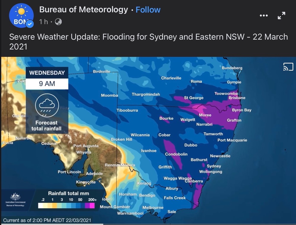
Currently NSW is experiencing one of its biggest flood events in several decades, with four times the monthly average rainfall seen already. NSW SES has received more than 8,000 requests for assistance to date and almost 850 Flood Rescues. NSW is expected to see another three days of heavy rainfall from Port Macquarie to Bega and riverine flooding that will continue for up to two to three weeks.
The NSW SES requested support from Victoria through the State Control Centre on Saturday, with the first VICSES Senior Command Team arriving at NSW SES HQ in Wollongong on Sunday. This team is coordinating Victoria’s multi-agency requests with the National Resource Sharing Centre (NRSC).
NSW has seen significant rainfall since Thursday 18 March 2021 with some areas seeing record rainfall rates resulting in minor to major flooding extending from Sydney up to and now across the Queensland border.
• 18,000 people have been evacuated – the majority of them on NSW’s Mid-North Coast.
• The NSW Mid-North Coast, the Hawkesbury valley and western NSW are the areas of most concern today as the state’s wild weather continues.
• More heavy rainfall is forecast across the state today and tomorrow.
• The Macleay River at Kempsey is expected to burst its banks in the coming hours.
• 38 areas in NSW are now “disaster zones”.
• Areas on the south coast of Queensland surrounding Brisbane are also experiencing extreme amounts of rain today.
The tail of the weather system impacting NSW will see heavy rainfall late Tuesday into Wednesday in East Gippsland.
A Severe Weather Warning was issued at 1715 hrs identifying:
• The parts of the warning area likely to be affected by HEAVY RAINFALL are the area east of Orbost and the area west of Sale, particularly about the Strzelecki Ranges.
• Rainfall totals of 70-130mm are possible within these areas from midday Tuesday afternoon through to midday Wednesday.
• A Flood Watch is current for the Bemm, Cann, Genoa and Snowy River catchments (for minor flooding potential), while a Minor Flood Warning is current for the Snowy River.
Rule 303 said:
Sitrep:NSW Floods
Situation Overview – Monday 22 March 2021
Currently NSW is experiencing one of its biggest flood events in several decades, with four times the monthly average rainfall seen already. NSW SES has received more than 8,000 requests for assistance to date and almost 850 Flood Rescues. NSW is expected to see another three days of heavy rainfall from Port Macquarie to Bega and riverine flooding that will continue for up to two to three weeks.
The NSW SES requested support from Victoria through the State Control Centre on Saturday, with the first VICSES Senior Command Team arriving at NSW SES HQ in Wollongong on Sunday. This team is coordinating Victoria’s multi-agency requests with the National Resource Sharing Centre (NRSC).
NSW has seen significant rainfall since Thursday 18 March 2021 with some areas seeing record rainfall rates resulting in minor to major flooding extending from Sydney up to and now across the Queensland border.
• 18,000 people have been evacuated – the majority of them on NSW’s Mid-North Coast.
• The NSW Mid-North Coast, the Hawkesbury valley and western NSW are the areas of most concern today as the state’s wild weather continues.
• More heavy rainfall is forecast across the state today and tomorrow.
• The Macleay River at Kempsey is expected to burst its banks in the coming hours.
• 38 areas in NSW are now “disaster zones”.
• Areas on the south coast of Queensland surrounding Brisbane are also experiencing extreme amounts of rain today.The tail of the weather system impacting NSW will see heavy rainfall late Tuesday into Wednesday in East Gippsland.
A Severe Weather Warning was issued at 1715 hrs identifying:• The parts of the warning area likely to be affected by HEAVY RAINFALL are the area east of Orbost and the area west of Sale, particularly about the Strzelecki Ranges.
• Rainfall totals of 70-130mm are possible within these areas from midday Tuesday afternoon through to midday Wednesday.
• A Flood Watch is current for the Bemm, Cann, Genoa and Snowy River catchments (for minor flooding potential), while a Minor Flood Warning is current for the Snowy River.
Hopefully Mallacoota has had enough regrowth so the whole thing doesn’t wash out to sea.
sibeen said:
Rule 303 said:
Sitrep:NSW Floods
Situation Overview – Monday 22 March 2021
Currently NSW is experiencing one of its biggest flood events in several decades, with four times the monthly average rainfall seen already. NSW SES has received more than 8,000 requests for assistance to date and almost 850 Flood Rescues. NSW is expected to see another three days of heavy rainfall from Port Macquarie to Bega and riverine flooding that will continue for up to two to three weeks.
The NSW SES requested support from Victoria through the State Control Centre on Saturday, with the first VICSES Senior Command Team arriving at NSW SES HQ in Wollongong on Sunday. This team is coordinating Victoria’s multi-agency requests with the National Resource Sharing Centre (NRSC).
NSW has seen significant rainfall since Thursday 18 March 2021 with some areas seeing record rainfall rates resulting in minor to major flooding extending from Sydney up to and now across the Queensland border.
• 18,000 people have been evacuated – the majority of them on NSW’s Mid-North Coast.
• The NSW Mid-North Coast, the Hawkesbury valley and western NSW are the areas of most concern today as the state’s wild weather continues.
• More heavy rainfall is forecast across the state today and tomorrow.
• The Macleay River at Kempsey is expected to burst its banks in the coming hours.
• 38 areas in NSW are now “disaster zones”.
• Areas on the south coast of Queensland surrounding Brisbane are also experiencing extreme amounts of rain today.The tail of the weather system impacting NSW will see heavy rainfall late Tuesday into Wednesday in East Gippsland.
A Severe Weather Warning was issued at 1715 hrs identifying:• The parts of the warning area likely to be affected by HEAVY RAINFALL are the area east of Orbost and the area west of Sale, particularly about the Strzelecki Ranges.
• Rainfall totals of 70-130mm are possible within these areas from midday Tuesday afternoon through to midday Wednesday.
• A Flood Watch is current for the Bemm, Cann, Genoa and Snowy River catchments (for minor flooding potential), while a Minor Flood Warning is current for the Snowy River.Hopefully Mallacoota has had enough regrowth so the whole thing doesn’t wash out to sea.
Floating houses ….
roughbarked said:
Floating houses ….
It worked for the Crimson Permanent Assurance Company…
“Several locations are on their way to getting over 1m of rain as a result of the wild weather of the last week and coming days“
https://www.abc.net.au/news/2021-03-22/national-rain-update/13266744
sibeen said:
Rule 303 said:
Sitrep:NSW Floods
Situation Overview – Monday 22 March 2021
Currently NSW is experiencing one of its biggest flood events in several decades, with four times the monthly average rainfall seen already. NSW SES has received more than 8,000 requests for assistance to date and almost 850 Flood Rescues. NSW is expected to see another three days of heavy rainfall from Port Macquarie to Bega and riverine flooding that will continue for up to two to three weeks.
The NSW SES requested support from Victoria through the State Control Centre on Saturday, with the first VICSES Senior Command Team arriving at NSW SES HQ in Wollongong on Sunday. This team is coordinating Victoria’s multi-agency requests with the National Resource Sharing Centre (NRSC).
NSW has seen significant rainfall since Thursday 18 March 2021 with some areas seeing record rainfall rates resulting in minor to major flooding extending from Sydney up to and now across the Queensland border.
• 18,000 people have been evacuated – the majority of them on NSW’s Mid-North Coast.
• The NSW Mid-North Coast, the Hawkesbury valley and western NSW are the areas of most concern today as the state’s wild weather continues.
• More heavy rainfall is forecast across the state today and tomorrow.
• The Macleay River at Kempsey is expected to burst its banks in the coming hours.
• 38 areas in NSW are now “disaster zones”.
• Areas on the south coast of Queensland surrounding Brisbane are also experiencing extreme amounts of rain today.The tail of the weather system impacting NSW will see heavy rainfall late Tuesday into Wednesday in East Gippsland.
A Severe Weather Warning was issued at 1715 hrs identifying:• The parts of the warning area likely to be affected by HEAVY RAINFALL are the area east of Orbost and the area west of Sale, particularly about the Strzelecki Ranges.
• Rainfall totals of 70-130mm are possible within these areas from midday Tuesday afternoon through to midday Wednesday.
• A Flood Watch is current for the Bemm, Cann, Genoa and Snowy River catchments (for minor flooding potential), while a Minor Flood Warning is current for the Snowy River.Hopefully Mallacoota has had enough regrowth so the whole thing doesn’t wash out to sea.
I would classify them as fairly high risk of being cut off, and moderate risk of infrastructure damage, at this point.
roughbarked said:
sibeen said:
Rule 303 said:
Sitrep:NSW Floods
Situation Overview – Monday 22 March 2021
Currently NSW is experiencing one of its biggest flood events in several decades, with four times the monthly average rainfall seen already. NSW SES has received more than 8,000 requests for assistance to date and almost 850 Flood Rescues. NSW is expected to see another three days of heavy rainfall from Port Macquarie to Bega and riverine flooding that will continue for up to two to three weeks.
The NSW SES requested support from Victoria through the State Control Centre on Saturday, with the first VICSES Senior Command Team arriving at NSW SES HQ in Wollongong on Sunday. This team is coordinating Victoria’s multi-agency requests with the National Resource Sharing Centre (NRSC).
NSW has seen significant rainfall since Thursday 18 March 2021 with some areas seeing record rainfall rates resulting in minor to major flooding extending from Sydney up to and now across the Queensland border.
• 18,000 people have been evacuated – the majority of them on NSW’s Mid-North Coast.
• The NSW Mid-North Coast, the Hawkesbury valley and western NSW are the areas of most concern today as the state’s wild weather continues.
• More heavy rainfall is forecast across the state today and tomorrow.
• The Macleay River at Kempsey is expected to burst its banks in the coming hours.
• 38 areas in NSW are now “disaster zones”.
• Areas on the south coast of Queensland surrounding Brisbane are also experiencing extreme amounts of rain today.The tail of the weather system impacting NSW will see heavy rainfall late Tuesday into Wednesday in East Gippsland.
A Severe Weather Warning was issued at 1715 hrs identifying:• The parts of the warning area likely to be affected by HEAVY RAINFALL are the area east of Orbost and the area west of Sale, particularly about the Strzelecki Ranges.
• Rainfall totals of 70-130mm are possible within these areas from midday Tuesday afternoon through to midday Wednesday.
• A Flood Watch is current for the Bemm, Cann, Genoa and Snowy River catchments (for minor flooding potential), while a Minor Flood Warning is current for the Snowy River.Hopefully Mallacoota has had enough regrowth so the whole thing doesn’t wash out to sea.
Floating houses ….
Somewhere a Chippy is watching each house float down the flood plain, saying “I built that! Look how well it’s staying in one piece… as it floats… down that river.”
Rule 303 said:
roughbarked said:
sibeen said:Hopefully Mallacoota has had enough regrowth so the whole thing doesn’t wash out to sea.
Floating houses ….
Somewhere a Chippy is watching each house float down the flood plain, saying “I built that! Look how well it’s staying in one piece… as it floats… down that river.”
and somewhere a farmer is saying there goes a whole piece of my land, carrying away all the structures upon it intact.
Looks like Penrith has been OK, hardly any mention of it on today’s news despite the flood peak last night.
That means Wiseman’s Ferry will be OK tonight.
roughbarked said:
Rule 303 said:
roughbarked said:Floating houses ….
Somewhere a Chippy is watching each house float down the flood plain, saying “I built that! Look how well it’s staying in one piece… as it floats… down that river.”
and somewhere a farmer is saying there goes a whole piece of my land, carrying away all the structures upon it intact.
Probably thinking to himself “I really should have listened to that Chippy that said we need antcaps and threaded bar.”
“ A landslide has closed one of the major roads out of Sydney today – and there are reports it will be closed for the “foreseeable future”.
Bells Line of Road, an alternative route across the Blue Mountains to the Great Western Highway, is closed in both directions between Darling Causeway and Rainbow Ravine Drive.”
Bells Line is hardly “a major road” nor is it “out of Sydney”. It’s about 116kms out of Sydney…
Rule 303 said:
roughbarked said:
Rule 303 said:Somewhere a Chippy is watching each house float down the flood plain, saying “I built that! Look how well it’s staying in one piece… as it floats… down that river.”
and somewhere a farmer is saying there goes a whole piece of my land, carrying away all the structures upon it intact.
Probably thinking to himself “I really should have listened to that Chippy that said we need antcaps and threaded bar.”
:)
Divine Angel said:
Bells Line is hardly “a major road” nor is it “out of Sydney”. It’s about 116kms out of Sydney…
As i recall it, Bells Line of Road was a slightly up-market goat track.
May have come on a bit since then.
Divine Angel said:
“ A landslide has closed one of the major roads out of Sydney today – and there are reports it will be closed for the “foreseeable future”.
Bells Line of Road, an alternative route across the Blue Mountains to the Great Western Highway, is closed in both directions between Darling Causeway and Rainbow Ravine Drive.”Bells Line is hardly “a major road” nor is it “out of Sydney”. It’s about 116kms out of Sydney…
These city centrists do go a bit out of their way at times.
Divine Angel said:
“ A landslide has closed one of the major roads out of Sydney today – and there are reports it will be closed for the “foreseeable future”.
Bells Line of Road, an alternative route across the Blue Mountains to the Great Western Highway, is closed in both directions between Darling Causeway and Rainbow Ravine Drive.”Bells Line is hardly “a major road” nor is it “out of Sydney”. It’s about 116kms out of Sydney…
Ddn’t some freeway replace it?
I very briefly had a job which dealt with property transfers in and around Sydney.
Bells Line of Road was a PITA back then
Every property seemed to be ‘Lot 1’ of something or other, and the titles bore no relation to what had transpired in the last decade.
Just pinning down what property was being referred to could take you half a day.
sarahs mum said:
Divine Angel said:
“ A landslide has closed one of the major roads out of Sydney today – and there are reports it will be closed for the “foreseeable future”.
Bells Line of Road, an alternative route across the Blue Mountains to the Great Western Highway, is closed in both directions between Darling Causeway and Rainbow Ravine Drive.”Bells Line is hardly “a major road” nor is it “out of Sydney”. It’s about 116kms out of Sydney…
Ddn’t some freeway replace it?
Great Western Highway is the main road over the Mts.
Dad had a property out past Bathurst. We took Bells Line rarely, because I always got carsick. It’s known for landslides and always closed with bushfires out there. Like the good Cap’n said, it’s not much more than a goat track. Dry pretty country though.
Tits been rainin’ at the Cosy Country Comfort Cottage since early last night non-stop.
Non-stop I tells ya.
Not much more than a heavy drizzle for most of it, but.
Non-stop I tells ya.
Did I tells ya it been non-stop?
95% of 50 – 90 moolies for tomorrow as well.
Woodie said:
Tits been rainin’ at the Cosy Country Comfort Cottage since early last night non-stop.Non-stop I tells ya.
Not much more than a heavy drizzle for most of it, but.
Non-stop I tells ya.
Did I tells ya it been non-stop?
95% of 50 – 90 moolies for tomorrow as well.
Friend at Newrybar ridge said he tipped out 287mm.
Woodie said:
Tits been rainin’ at the Cosy Country Comfort Cottage since early last night non-stop.Non-stop I tells ya.
Not much more than a heavy drizzle for most of it, but.
Non-stop I tells ya.
Did I tells ya it been non-stop?
95% of 50 – 90 moolies for tomorrow as well.
You’ll have to do more maaarn when it stops…
Michael V said:
Woodie said:
Tits been rainin’ at the Cosy Country Comfort Cottage since early last night non-stop.Non-stop I tells ya.
Not much more than a heavy drizzle for most of it, but.
Non-stop I tells ya.
Did I tells ya it been non-stop?
95% of 50 – 90 moolies for tomorrow as well.
You’ll have to do more maaarn when it stops…
He’s going to have mowing? I was trying to carefully use the free water I’ve had now for more than two weeks because I don’t want extra work tidying up weeds and it goes and bloody rains on top of all that.
Michael V said:
Woodie said:
Tits been rainin’ at the Cosy Country Comfort Cottage since early last night non-stop.Non-stop I tells ya.
Not much more than a heavy drizzle for most of it, but.
Non-stop I tells ya.
Did I tells ya it been non-stop?
95% of 50 – 90 moolies for tomorrow as well.
You’ll have to do more maaarn when it stops…
The driveway’s a bog. Even the Golden Girl did done wheelies up it tonight. Mind you, I had the trailer on the back. Had to take it to town to get pink slip for rego for it.
Woodie said:
Michael V said:
Woodie said:
Tits been rainin’ at the Cosy Country Comfort Cottage since early last night non-stop.Non-stop I tells ya.
Not much more than a heavy drizzle for most of it, but.
Non-stop I tells ya.
Did I tells ya it been non-stop?
95% of 50 – 90 moolies for tomorrow as well.
You’ll have to do more maaarn when it stops…
The driveway’s a bog. Even the Golden Girl did done wheelies up it tonight. Mind you, I had the trailer on the back. Had to take it to town to get pink slip for rego for it.
Bugger.
No bogs here, unless I want to go on the beach…
Michael V said:
Woodie said:
Michael V said:You’ll have to do more maaarn when it stops…
The driveway’s a bog. Even the Golden Girl did done wheelies up it tonight. Mind you, I had the trailer on the back. Had to take it to town to get pink slip for rego for it.
Bugger.
No bogs here, unless I want to go on the beach…
I’m fine unless I choose the wrong road for the weather and even then I know how to get down there.

BOM says I am going to get a couple of inches on Wodinsday.
sarahs mum said:
BOM says I am going to get a couple of inches on Wodinsday.
The magic wand gets waved around here on Wensdee. A miracle I tells ya, is about to happen. After 40 days and 40 nights.
Woodie said:
sarahs mum said:
BOM says I am going to get a couple of inches on Wodinsday.The magic wand gets waved around here on Wensdee. A miracle I tells ya, is about to happen. After 40 days and 40 nights.
I knew you were into wood but had no idea it was about ark construction.
Oh yeah. ummmm… yeah…… I almost forgot.
Did I tells ya it’s still rainin’?
Did I? Can’t remember.
It’s been goin’ on so long I’ve forgot.
Anyway, if I ain’t tolds ya.
It’s still rainin’. Yeah. Still.
Woodie said:
Oh yeah. ummmm… yeah…… I almost forgot.Did I tells ya it’s still rainin’?
Did I? Can’t remember.
It’s been goin’ on so long I’ve forgot.
Anyway, if I ain’t tolds ya.
It’s still rainin’. Yeah. Still.
Yeah, rain, rainin’.. more rain, rainin etc. I noticed.
Here we had 97 mm in 24 hrs to 0900 Mon
And 59 mm to 0900 today
Possible major flood warnings for the Orara at Coutts’s and the Clarence at Grafton..
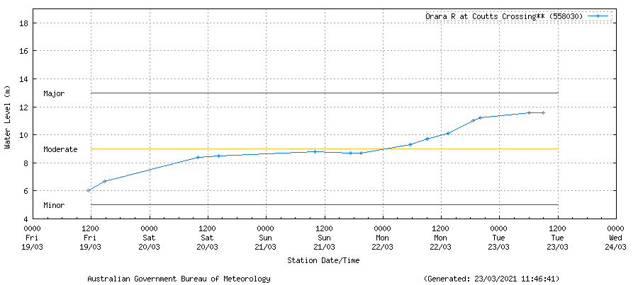
.
But I can see the beginning of the end. It should mostly clear out this evening..
Gonna be hot and steamy here tomorrow. Forty percent chance of rain but 31 degrees.
Divine Angel said:
Gonna be hot and steamy here tomorrow. Forty percent chance of rain but 31 degrees.
Wednesday 24 March
Summary Min 16 Max 19 Rain. Possible heavy falls. Possible rainfall: 25 to 70 mm Chance of any rain: 95%
Hobart area
Cloudy. Very high (95%) chance of rain, most likely in the afternoon and evening. Heavy falls possible. Winds easterly 15 to 20 km/h increasing to 25 to 40 km/h before dawn then turning southeasterly 30 to 35 km/h in the evening.
Divine Angel said:
Gonna be hot and steamy here tomorrow. Forty percent chance of rain but 31 degrees.
Shit yeah.. Sunny and 33.. steambath mode
Ian said:
Woodie said:
Oh yeah. ummmm… yeah…… I almost forgot.Did I tells ya it’s still rainin’?
Did I? Can’t remember.
It’s been goin’ on so long I’ve forgot.
Anyway, if I ain’t tolds ya.
It’s still rainin’. Yeah. Still.
Yeah, rain, rainin’.. more rain, rainin etc. I noticed.
Here we had 97 mm in 24 hrs to 0900 Mon
And 59 mm to 0900 todayPossible major flood warnings for the Orara at Coutts’s and the Clarence at Grafton..
.
But I can see the beginning of the end. It should mostly clear out this evening..
See? I tolds ya, Mr Ian. It’s still rainin’ Sheesh…… doesn’t anybody listen to anything I have to say?
And just in case anyone else wants to know.
It’s still rainin’. Always has, and always will be the looks of it.
Haven’t had any of this mainland moisture here yet but tomorrow’s forecast is Rain, possible heavy falls.
Just when Helen is driving down from Launceston to cut villagers’ hair (including mine).
Bubblecar said:
Haven’t had any of this mainland moisture here yet but tomorrow’s forecast is Rain, possible heavy falls.Just when Helen is driving down from Launceston to cut villagers’ hair (including mine).
What, no local haircutters? Have you asked Mr Tunks?
Ian said:
Bubblecar said:
Haven’t had any of this mainland moisture here yet but tomorrow’s forecast is Rain, possible heavy falls.Just when Helen is driving down from Launceston to cut villagers’ hair (including mine).
What, no local haircutters? Have you asked Mr Tunks?
Mr Tunks only does haircuts with the whippersnipper.
Ian said:
Bubblecar said:
Haven’t had any of this mainland moisture here yet but tomorrow’s forecast is Rain, possible heavy falls.Just when Helen is driving down from Launceston to cut villagers’ hair (including mine).
What, no local haircutters? Have you asked Mr Tunks?
Mr Tunks does indeed do haircuts (he cut my Ross bro-in-law’s hair recently) but my hair requires a professional, accustomed to cutting long hair.
There are other local hairdressers but Helen’s been cutting my hair for a long time and these days does convenient home visits.
Bubblecar said:
Haven’t had any of this mainland moisture here yet but tomorrow’s forecast is Rain, possible heavy falls.Just when Helen is driving down from Launceston to cut villagers’ hair (including mine).
Does she have your haircut records
Cymek said:
Bubblecar said:
Haven’t had any of this mainland moisture here yet but tomorrow’s forecast is Rain, possible heavy falls.Just when Helen is driving down from Launceston to cut villagers’ hair (including mine).
Does she have your haircut records
I doubt that she keeps records.
party_pants said:
Ian said:
Bubblecar said:
Haven’t had any of this mainland moisture here yet but tomorrow’s forecast is Rain, possible heavy falls.Just when Helen is driving down from Launceston to cut villagers’ hair (including mine).
What, no local haircutters? Have you asked Mr Tunks?
Mr Tunks only does haircuts with the whippersnipper.
Bubble’s hair is long enough for that.
Bubblecar said:
Cymek said:
Bubblecar said:
Haven’t had any of this mainland moisture here yet but tomorrow’s forecast is Rain, possible heavy falls.Just when Helen is driving down from Launceston to cut villagers’ hair (including mine).
Does she have your haircut records
I doubt that she keeps records.
She has a record of every hair on your head. Just hope she doesn’t forget.
“ Speaking in Parliament, Federal Emergency Services Minister David Littleproud says he’s “just been advised” by Coles that they’re going to fly in goods to North Richmond.
He’s been in touch with the supermarket giant after he was warned by NSW Senator (and government minister) Marise Payne and Labor MP Susan Templeman that there were food shortages in supermarkets in Western Sydney.
“They intend to helicopter goods into North Richmond’s store this afternoon, as soon as arrangements can be made,” he said.”
From the ABC blog.
http://www.bom.gov.au/cgi-bin/wrap_fwo.pl?IDN60143.html
Latest River Heights for the NSW Central Coast
Issued at 9.15pm on Tuesday, 23 March 2021
Major flooding only at the following locations on the central coast and only one of those is rising.
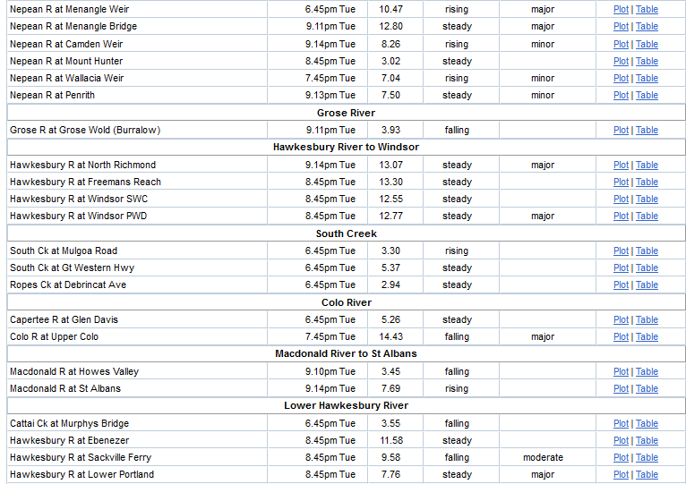
Rising water level in the Nepean at Menangle.
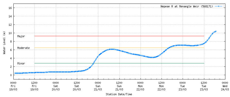
Penrith escaped with only moderate flooding

Windsor
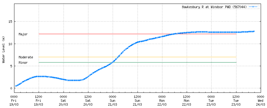
Lower Portland
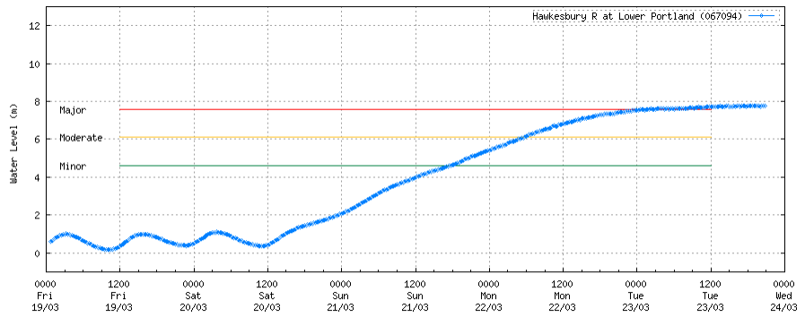
I summary, no major catastrophe seen so far or in the next few days for anywhere in the NSW Central Coast.
Since 7 o’clock Mallacoota got just over 60 mm. Hopefully not too much soil has washed away.
…… and don’t forget Grafton, Mr Fumble.
Look what it’s heading for.
….. and these are 50km & 100 kms from Grafton and yet to come.


ABC Capricornia
2 hrs ·
Wow 😍⛈️
More than 46mm of rain fell at Uluṟu-Kata Tjuṯa National Park over the weekend.
The downpour created these stunning waterfalls cascading down Uluru.
sarahs mum said:
ABC Capricornia
2 hrs ·
Wow 😍⛈️
More than 46mm of rain fell at Uluṟu-Kata Tjuṯa National Park over the weekend.
The downpour created these stunning waterfalls cascading down Uluru.
Well , you don’t see that everyday huh?
Apparently residents of Pimpama have been advised to get to higher ground north tip of the GC
monkey skipper said:
sarahs mum said:
ABC Capricornia
2 hrs ·
Wow 😍⛈️
More than 46mm of rain fell at Uluṟu-Kata Tjuṯa National Park over the weekend.
The downpour created these stunning waterfalls cascading down Uluru.
Well , you don’t see that everyday huh?
I think that “stunning “ is over selling it just a bit…
furious said:
monkey skipper said:
sarahs mum said:
ABC Capricornia
2 hrs ·
Wow 😍⛈️
More than 46mm of rain fell at Uluṟu-Kata Tjuṯa National Park over the weekend.
The downpour created these stunning waterfalls cascading down Uluru.
Well , you don’t see that everyday huh?
- The downpour created these stunning waterfalls cascading down Uluru.
I think that “stunning “ is over selling it just a bit…
I thought it was a good show for 46mm.
sarahs mum said:
furious said:
monkey skipper said:Well , you don’t see that everyday huh?
- The downpour created these stunning waterfalls cascading down Uluru.
I think that “stunning “ is over selling it just a bit…
I thought it was a good show for 46mm.
Its not bad, if I was there I’d be like, that’s pretty cool. Not, that’s stunning…
monkey skipper said:
sarahs mum said:
ABC Capricornia
2 hrs ·
Wow 😍⛈️
More than 46mm of rain fell at Uluṟu-Kata Tjuṯa National Park over the weekend.
The downpour created these stunning waterfalls cascading down Uluru.
Well , you don’t see that everyday huh?
You can see why the Aborigines hold it in such high regard, it is very impressive.
PermeateFree said:
monkey skipper said:
sarahs mum said:
ABC Capricornia
2 hrs ·
Wow 😍⛈️
More than 46mm of rain fell at Uluṟu-Kata Tjuṯa National Park over the weekend.
The downpour created these stunning waterfalls cascading down Uluru.
Well , you don’t see that everyday huh?
You can see why the Aborigines hold it in such high regard, it is very impressive.
Yes, water runs off it when it rains. Just like my roof. Very impressive…
furious said:
sarahs mum said:
furious said:
- The downpour created these stunning waterfalls cascading down Uluru.
I think that “stunning “ is over selling it just a bit…
I thought it was a good show for 46mm.
Its not bad, if I was there I’d be like, that’s pretty cool. Not, that’s stunning…
You need to appreciate that water in the outback is precious and usually only found in small quantities. To have water cascading down and filling each hollow is extremely unusual. I have seen a sacred site in the Tennent Creek region, where in a small gorge, water cascaded down around 5 hollows and even provided suitable habitat for fish, thereby illustrating the permanency of it.
PermeateFree said:
furious said:
sarahs mum said:I thought it was a good show for 46mm.
Its not bad, if I was there I’d be like, that’s pretty cool. Not, that’s stunning…
You need to appreciate that water in the outback is precious and usually only found in small quantities. To have water cascading down and filling each hollow is extremely unusual. I have seen a sacred site in the Tennent Creek region, where in a small gorge, water cascaded down around 5 hollows and even provided suitable habitat for fish, thereby illustrating the permanency of it.
Yeah. It is cool. But not stunning…
furious said:
PermeateFree said:
furious said:Its not bad, if I was there I’d be like, that’s pretty cool. Not, that’s stunning…
You need to appreciate that water in the outback is precious and usually only found in small quantities. To have water cascading down and filling each hollow is extremely unusual. I have seen a sacred site in the Tennent Creek region, where in a small gorge, water cascaded down around 5 hollows and even provided suitable habitat for fish, thereby illustrating the permanency of it.
Yeah. It is cool. But not stunning…
To me and most Aborigines it is, maybe we see something of the bigger picture that rainwater off a roof does not capture.
PermeateFree said:
furious said:
PermeateFree said:You need to appreciate that water in the outback is precious and usually only found in small quantities. To have water cascading down and filling each hollow is extremely unusual. I have seen a sacred site in the Tennent Creek region, where in a small gorge, water cascaded down around 5 hollows and even provided suitable habitat for fish, thereby illustrating the permanency of it.
Yeah. It is cool. But not stunning…
To me and most Aborigines it is, maybe we see something of the bigger picture that rainwater off a roof does not capture.
“Stunning” is subjective. I dont find it “stunning”.
furious said:
PermeateFree said:
furious said:Yeah. It is cool. But not stunning…
To me and most Aborigines it is, maybe we see something of the bigger picture that rainwater off a roof does not capture.
“Stunning” is subjective. I dont find it “stunning”.
I think we gathered that.
Woodie said:
…… and don’t forget Grafton, Mr Fumble.Look what it’s heading for.
….. and these are 50km & 100 kms from Grafton and yet to come.
Thanks, Woodie. Grafton definitely a worry.
We must have flood protection installed for all Australian towns.
Thanks too, Sarah’s mum. From WA, the rain in the Kimberleys moved south to meet up with another source of rain on the western SA border, then moved east along the SA border into southern Qld to join up with the SE Qld rain.
Have we heard from Ian in the last couple of days?
I wonder how he’s going, and whether he’s gotten his horses to non-flooding ground? (He’s upstream from Grafton.)
Steve (Primus) will be watching his back yard carefully, I reckon. (His block of land backs onto the river.)
https://www.abc.net.au/news/2021-03-24/nsw-weather-live-updates-flooding-disaster/100024790
Michael V said:
Steve (Primus) will be watching his back yard carefully, I reckon. (His block of land backs onto the river.)https://www.abc.net.au/news/2021-03-24/nsw-weather-live-updates-flooding-disaster/100024790
I think it comes into town at around 12 metres.
furious said:
monkey skipper said:
sarahs mum said:
ABC Capricornia
2 hrs ·
Wow 😍⛈️
More than 46mm of rain fell at Uluṟu-Kata Tjuṯa National Park over the weekend.
The downpour created these stunning waterfalls cascading down Uluru.
Well , you don’t see that everyday huh?
- The downpour created these stunning waterfalls cascading down Uluru.
I think that “stunning “ is over selling it just a bit…
wet, is appropriate.
Woodie said:
Michael V said:
Steve (Primus) will be watching his back yard carefully, I reckon. (His block of land backs onto the river.)https://www.abc.net.au/news/2021-03-24/nsw-weather-live-updates-flooding-disaster/100024790
I think it comes into town at around 12 metres.
OK. All’s well then.
:)
Just spoke to my mother, she reckons last night’s storm hitting Mallacoota was definitely the worst she’s gone through down there. They got 107 mm and she thought the roof was going to blow off. They lost power at 10 last night and still don’t have it back.
sibeen said:
Just spoke to my mother, she reckons last night’s storm hitting Mallacoota was definitely the worst she’s gone through down there. They got 107 mm and she thought the roof was going to blow off. They lost power at 10 last night and still don’t have it back.
Hinze 361, 684 ML 116.4% 3:55pm 24/03/2021 Dam is spilling
Wivenhoe 431, 120 ML 37.0% 1:34pm 24/03/2021
Woodie said:
…… and don’t forget Grafton, Mr Fumble.Look what it’s heading for.
….. and these are 50km & 100 kms from Grafton and yet to come.
Less than 2 m of freeboard.
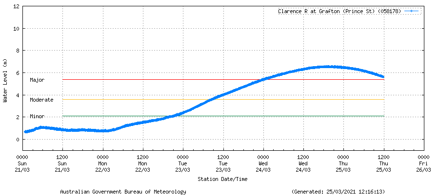
Good thing Grafton didn’t go big :P
245 mm here for the week till the rain stopped.
Someone got anxious and tackled the causeway at 1.4 m.
Noob
Ian said:
245 mm here for the week till the rain stopped.
Someone got anxious and tackled the causeway at 1.4 m.
Noob
Is Coutts able to cross yet Mr Ian?
Woodie said:
Ian said:
245 mm here for the week till the rain stopped.
Someone got anxious and tackled the causeway at 1.4 m.
Noob
Is Coutts able to cross yet Mr Ian?
Coutts to Grafton is open. But that’s the water this morning blocking me.
How high did your creek get Mr Woo?
Ian said:
Woodie said:
Ian said:
245 mm here for the week till the rain stopped.
Someone got anxious and tackled the causeway at 1.4 m.
Noob
Is Coutts able to cross yet Mr Ian?
Coutts to Grafton is open. But that’s the water this morning blocking me.
At least in your country it drains more quickly than it does here. That amount of water would stay for weeks or until it eventually evaporated.
sarahs mum said:
ABC Capricornia
2 hrs ·
Wow 😍⛈️
More than 46mm of rain fell at Uluṟu-Kata Tjuṯa National Park over the weekend.
The downpour created these stunning waterfalls cascading down Uluru.
roughbarked said:
Ian said:
Woodie said:Is Coutts able to cross yet Mr Ian?
Coutts to Grafton is open. But that’s the water this morning blocking me.
At least in your country it drains more quickly than it does here. That amount of water would stay for weeks or until it eventually evaporated.
Yeah. It’s flat.