Date: 31/12/2021 17:01:08
From: Michael V
ID: 1830283
Subject: Tropical Cyclone Seth.

BoM called it a couple of hours ago. We now have a track map. I expect that it will change considerably over the next few days.

This was the tropical low that was threatening to become a cyclone near Darwin on Boxing day, but didn’t. It is now in the Coral Sea.

Reply Quote

Date: 31/12/2021 17:21:23
From: mollwollfumble
ID: 1830292
Subject: re: Tropical Cyclone Seth.

Michael V said:


BoM called it a couple of hours ago. We now have a track map. I expect that it will change considerably over the next few days.

This was the tropical low that was threatening to become a cyclone near Darwin on Boxing day, but didn’t. It is now in the Coral Sea.

> Expected to bring large swells to the south-east Queensland coastline over the weekend.

So it you know any large swells, you know where to direct them.

Come to think of it, I know a Byron Bay surfer.

Reply Quote

Date: 31/12/2021 19:23:57
From: Michael V
ID: 1830324
Subject: re: Tropical Cyclone Seth.

Didn’t take long. Declared about 2pm. Intensified to Category 2 cyclone by 4pm.

Ooh-aah.

Reply Quote

Date: 1/01/2022 01:36:30
From: Michael V
ID: 1830489
Subject: re: Tropical Cyclone Seth.

New forecast track map: 10:47pm, 31/12/21.

Reply Quote

Date: 1/01/2022 01:41:31
From: Woodie
ID: 1830491
Subject: re: Tropical Cyclone Seth.

I reckon you ‘ve got til Thursday about 5pm to live, Mr. V Then it’s all over.

Reply Quote

Date: 1/01/2022 01:50:24
From: Michael V
ID: 1830495
Subject: re: Tropical Cyclone Seth.

Woodie said:


I reckon you ‘ve got til Thursday about 5pm to live, Mr. V Then it’s all over.

Na. I’ll keep tracking it and If I need to, a cuppla days beforehand I’ll tidy up the yard and weight and tie things down. If it gets to Cat 5, then I’ll come up with Plan B.

Reply Quote

Date: 1/01/2022 09:56:58
From: Michael V
ID: 1830556
Subject: re: Tropical Cyclone Seth.

Latest TC Seth Forecast Track Map, issued at 4:56 am AEST Saturday 1 January 2022. The next Forecast Track Map will be issued by 11:00 am AEST Saturday. Not much has changed in the forecast since last night.

Reply Quote

Date: 1/01/2022 11:29:51
From: Ian
ID: 1830603
Subject: re: Tropical Cyclone Seth.

Michael V said:


Latest TC Seth Forecast Track Map, issued at 4:56 am AEST Saturday 1 January 2022. The next Forecast Track Map will be issued by 11:00 am AEST Saturday. Not much has changed in the forecast since last night.


Look it’s all over the place.

Somebody’s going to get wet.

Probably.

Possibly.

Reply Quote

Date: 1/01/2022 11:41:03
From: Michael V
ID: 1830612
Subject: re: Tropical Cyclone Seth.

Ian said:


Michael V said:

Latest TC Seth Forecast Track Map, issued at 4:56 am AEST Saturday 1 January 2022. The next Forecast Track Map will be issued by 11:00 am AEST Saturday. Not much has changed in the forecast since last night.


Look it’s all over the place.

Somebody’s going to get wet.

Probably.

Possibly.

It could be us Wednesday night. This is from the BoM’s latest model. However their model has changed considerably day by day and has not firmed up yet, I don’t think.

http://www.bom.gov.au/australia/charts/viewer/index.shtml?type=mslp-precip&tz=AEDT&area=Qld&model=CSCG&chartSubmit=Refresh+View

Reply Quote

Date: 1/01/2022 11:48:01
From: Ian
ID: 1830613
Subject: re: Tropical Cyclone Seth.

Michael V said:


Ian said:

Michael V said:

Latest TC Seth Forecast Track Map, issued at 4:56 am AEST Saturday 1 January 2022. The next Forecast Track Map will be issued by 11:00 am AEST Saturday. Not much has changed in the forecast since last night.


Look it’s all over the place.

Somebody’s going to get wet.

Probably.

Possibly.

It could be us Wednesday night. This is from the BoM’s latest model. However their model has changed considerably day by day and has not firmed up yet, I don’t think.

http://www.bom.gov.au/australia/charts/viewer/index.shtml?type=mslp-precip&tz=AEDT&area=Qld&model=CSCG&chartSubmit=Refresh+View

Good thing it’s only a cat 1

Or that’s their current reckoning…

Reply Quote

Date: 1/01/2022 11:55:00
From: Woodie
ID: 1830616
Subject: re: Tropical Cyclone Seth.

Although this one doesn’t say much ‘cept maybe a bit breezy.

Reply Quote

Date: 1/01/2022 11:57:57
From: Michael V
ID: 1830617
Subject: re: Tropical Cyclone Seth.

Ian said:


Michael V said:

Ian said:

Look it’s all over the place.

Somebody’s going to get wet.

Probably.

Possibly.

It could be us Wednesday night. This is from the BoM’s latest model. However their model has changed considerably day by day and has not firmed up yet, I don’t think.

http://www.bom.gov.au/australia/charts/viewer/index.shtml?type=mslp-precip&tz=AEDT&area=Qld&model=CSCG&chartSubmit=Refresh+View

Good thing it’s only a cat 1

Or that’s their current reckoning…

It’s actually currently Cat 2, but expected to weaken. Who knows at this stage? Coral Sea cyclones are notoriously difficult to predict.

I’ll keep my eye on it, and if it looks like it’ll blow a bit of stuff around at Rainbow Beach, I’ll tie or weigh things down, 24-48 hours beforehand. Otherwise, laziness is my preferred model of storm preparation.

I might consider making some protection for the gas lines, too.

Reply Quote

Date: 1/01/2022 11:59:49
From: Michael V
ID: 1830619
Subject: re: Tropical Cyclone Seth.

Woodie said:


Although this one doesn’t say much ‘cept maybe a bit breezy.


It looks like keeping me amused and off the streets for a few days.

:)

Reply Quote

Date: 1/01/2022 12:02:38
From: Michael V
ID: 1830623
Subject: re: Tropical Cyclone Seth.

Latest: it has been downgraded to a Cat 1. I was wrong about it being a Cat 2 currently.

Reply Quote

Date: 1/01/2022 18:13:12
From: Michael V
ID: 1830721
Subject: re: Tropical Cyclone Seth.

Latest:

Reply Quote

Date: 2/01/2022 09:32:54
From: Michael V
ID: 1830808
Subject: re: Tropical Cyclone Seth.

This morning’s predictions:

Reply Quote

Date: 2/01/2022 09:34:30
From: roughbarked
ID: 1830809
Subject: re: Tropical Cyclone Seth.

Michael V said:


This morning’s predictions:


Looks like you can toss your clothes in the surf to wash them?

Reply Quote

Date: 2/01/2022 09:36:16
From: Michael V
ID: 1830811
Subject: re: Tropical Cyclone Seth.

roughbarked said:


Michael V said:

This morning’s predictions:


Looks like you can toss your clothes in the surf to wash them?

Surf was pretty dirty yesterday arvo. Lots of sand and debris.

Reply Quote

Date: 2/01/2022 09:39:28
From: roughbarked
ID: 1830812
Subject: re: Tropical Cyclone Seth.

Michael V said:


roughbarked said:

Michael V said:

This morning’s predictions:


Looks like you can toss your clothes in the surf to wash them?

Surf was pretty dirty yesterday arvo. Lots of sand and debris.

I was implying churning surf, yes.

Reply Quote

Date: 2/01/2022 09:46:46
From: captain_spalding
ID: 1830814
Subject: re: Tropical Cyclone Seth.

roughbarked said:


Michael V said:

This morning’s predictions:


Looks like you can toss your clothes in the surf to wash them?

A popular laundry method in small warships of old (like WW2) where there was very limited fresh water was to take a 44 -gal drum and liberally pierce it with holes.

Dirty clothes would be placed in the drum, the lid securely fastened on, and the whole thing went over the side to be towed in the ship’s wake for a while at the end of a stout line.

This was good for work clothes, overalls etc. You didn’t subject your best uniform to it.

Reply Quote

Date: 2/01/2022 09:49:48
From: Peak Warming Man
ID: 1830815
Subject: re: Tropical Cyclone Seth.

captain_spalding said:


roughbarked said:

Michael V said:

This morning’s predictions:


Looks like you can toss your clothes in the surf to wash them?

A popular laundry method in small warships of old (like WW2) where there was very limited fresh water was to take a 44 -gal drum and liberally pierce it with holes.

Dirty clothes would be placed in the drum, the lid securely fastened on, and the whole thing went over the side to be towed in the ship’s wake for a while at the end of a stout line.

This was good for work clothes, overalls etc. You didn’t subject your best uniform to it.

Were the heads in use at the same time?

Reply Quote

Date: 2/01/2022 09:55:36
From: captain_spalding
ID: 1830817
Subject: re: Tropical Cyclone Seth.

Peak Warming Man said:


captain_spalding said:

roughbarked said:

Looks like you can toss your clothes in the surf to wash them?

A popular laundry method in small warships of old (like WW2) where there was very limited fresh water was to take a 44 -gal drum and liberally pierce it with holes.

Dirty clothes would be placed in the drum, the lid securely fastened on, and the whole thing went over the side to be towed in the ship’s wake for a while at the end of a stout line.

This was good for work clothes, overalls etc. You didn’t subject your best uniform to it.

Were the heads in use at the same time?

It’s a big ocean, and big spinning bronze propellors are terrific at rapid discombooberation of soft materials.

Reply Quote

Date: 2/01/2022 13:33:00
From: Michael V
ID: 1830908
Subject: re: Tropical Cyclone Seth.

11 am today:

Reply Quote

Date: 2/01/2022 13:34:58
From: Tamb
ID: 1830911
Subject: re: Tropical Cyclone Seth.

Michael V said:


11 am today:


Heading north to the warmer water to reform.

Reply Quote

Date: 2/01/2022 13:37:44
From: Michael V
ID: 1830915
Subject: re: Tropical Cyclone Seth.

Tamb said:


Michael V said:

11 am today:


Heading north to the warmer water to reform.

Maybe…

Reply Quote

Date: 2/01/2022 20:02:58
From: Michael V
ID: 1831022
Subject: re: Tropical Cyclone Seth.

It’s an ex-TC now:

http://www.bom.gov.au/products/IDQ65002.shtml

———————————————————————————————————————————————————————————————————-

IDQ20065
Australian Bureau of Meteorology
Tropical Cyclone Warning Centre

TROPICAL CYCLONE INFORMATION BULLETIN
Issued at 4:17 pm EST on Sunday 2 January 2022

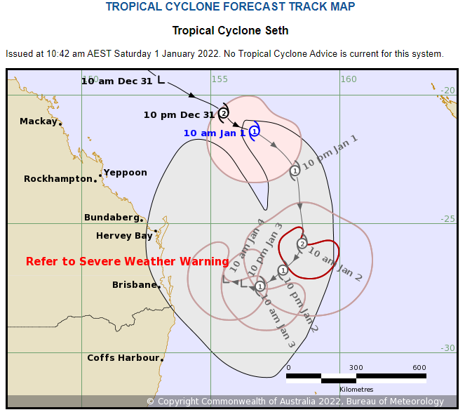
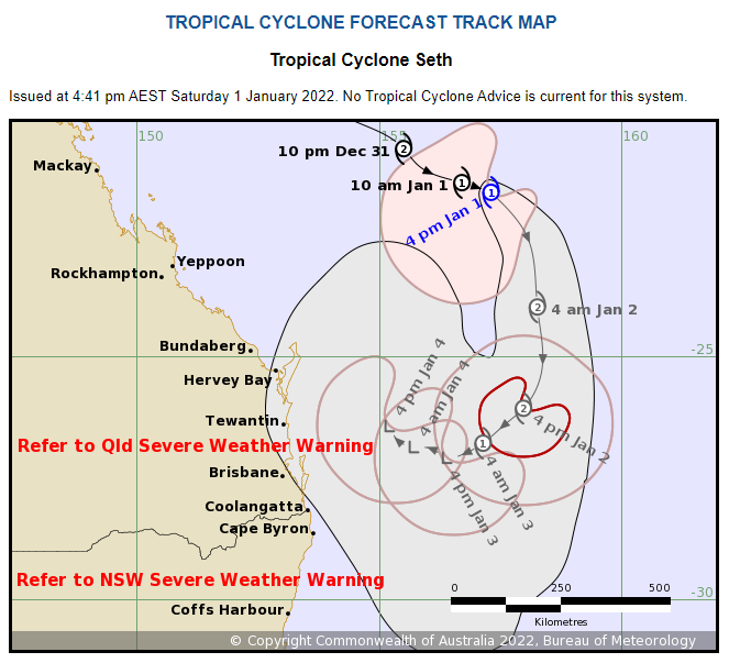
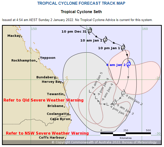
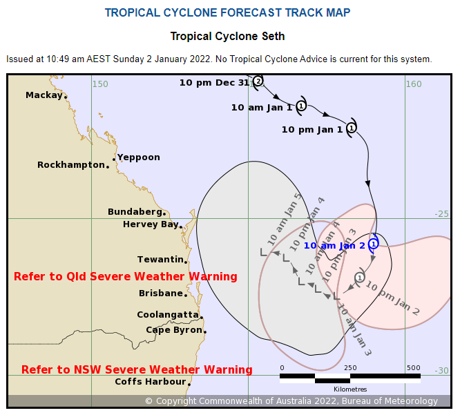
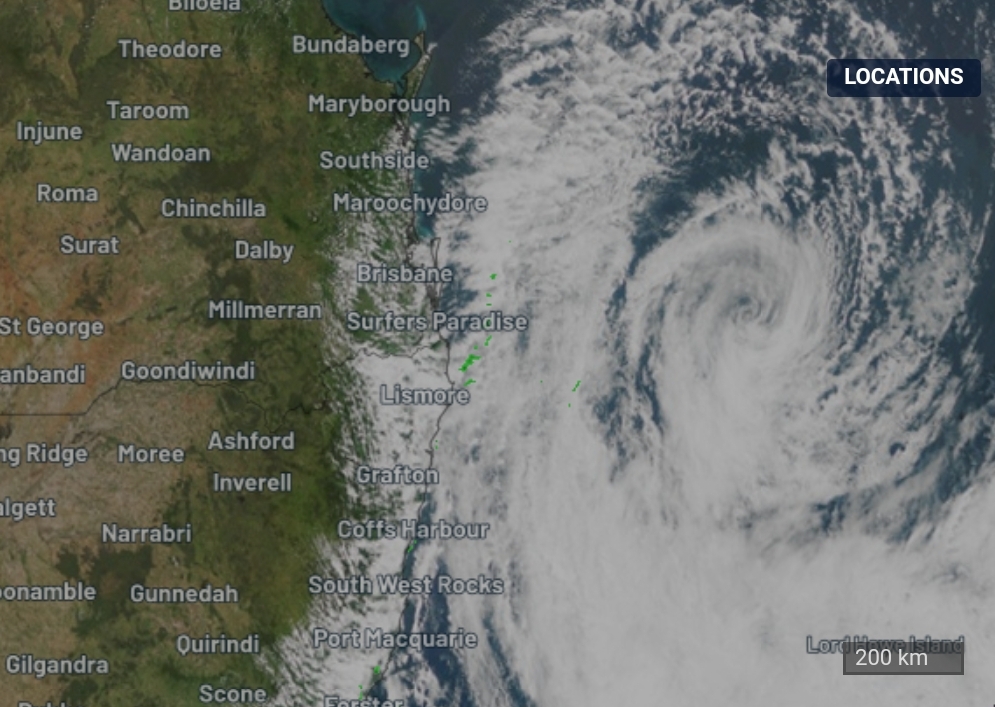
At 4 pm AEST Sunday, Ex-Tropical Cyclone Seth with central pressure 987 hPa was
located
near latitude 26.5 south longitude 158.6 east, which is about 590 km east
southeast of Hervey Bay and 560 km east of Brisbane.

The system is moving south southwest at 15 kilometres per hour.

Ex-Tropical Cyclone Seth has transitioned to a sub-tropical system. Although it
is no longer classified as a tropical cyclone, the system will continue to
produce gale force winds as it moves south to south-westward during the
remainder of Sunday.

On Monday, Ex-Tropical Cyclone Seth is expected to take a more westward motion
and may approach the northern NSW or southern QLD coasts mid-week, however the
exact path the system takes is uncertain at this time.

Ex-Tropical Cyclone Seth is not expected to directly impact the coastline in
the next 48 hours, however it will cause dangerous surf, abnormally high tides
about the southeast Queensland and northeast New South Wales coastlines. If the
remnants of the system approach the southeast Queensland coast during Tuesday
and Wednesday, strong and gusty winds, possibly damaging may develop ahead of
the system. Separate Severe Weather Warnings are current for these conditions;
refer to those products for more information.

This will be the last Information Bulletin issued for this system.

http://www.bom.gov.au/cgi-bin/wrap_fwo.pl?IDQ20065.txt

Reply Quote

Date: 3/01/2022 09:35:52
From: Ian
ID: 1831128
Subject: re: Tropical Cyclone Seth.

Severe Weather Warning for Damaging Winds for parts of Northern Rivers Forecast District. Issued at 4:52 am Monday, 3 January 2022.

Damaging wind gusts possible over far northeast New South Wales from Monday afternoon. Weather Situation Ex-Tropical Cyclone Seth is currently located over the southern Coral Sea. This system is forecast to adopt a west to northwesterly track, approaching the Queensland coast during the first half of the week. DAMAGING WINDS for the following areas: Northern Rivers DAMAGING WIND GUSTS with peak gusts of around 100 km/h are possible over coastal areas and ranges across far northeastern New South Wales from mid-afternoon on Monday. Winds are expected to ease during the day on Tuesday. A separate Severe Weather Warning for damaging surf and abnormally high tides is current for coastal areas of the Northern Rivers and Mid North Coast forecast districts.

Locations which may be affected include Tweed Heads, Byron Bay, Ballina, Alstonville, Brunswick Heads and Evans Head.

——

It’s gusting up quite a bit here.

Much mowing to do regardless..

Reply Quote

Date: 3/01/2022 09:46:29
From: Woodie
ID: 1831133
Subject: re: Tropical Cyclone Seth.

Ian said:


Severe Weather Warning for Damaging Winds for parts of Northern Rivers Forecast District. Issued at 4:52 am Monday, 3 January 2022.

Damaging wind gusts possible over far northeast New South Wales from Monday afternoon. Weather Situation Ex-Tropical Cyclone Seth is currently located over the southern Coral Sea. This system is forecast to adopt a west to northwesterly track, approaching the Queensland coast during the first half of the week. DAMAGING WINDS for the following areas: Northern Rivers DAMAGING WIND GUSTS with peak gusts of around 100 km/h are possible over coastal areas and ranges across far northeastern New South Wales from mid-afternoon on Monday. Winds are expected to ease during the day on Tuesday. A separate Severe Weather Warning for damaging surf and abnormally high tides is current for coastal areas of the Northern Rivers and Mid North Coast forecast districts.

Locations which may be affected include Tweed Heads, Byron Bay, Ballina, Alstonville, Brunswick Heads and Evans Head.

——

It’s gusting up quite a bit here.

Much mowing to do regardless..

Hardly a ruffle of the curtains here, ATM.

Reply Quote

Date: 3/01/2022 11:51:28
From: Ian
ID: 1831218
Subject: re: Tropical Cyclone Seth.

Woodie said:


Ian said:

Severe Weather Warning for Damaging Winds for parts of Northern Rivers Forecast District. Issued at 4:52 am Monday, 3 January 2022.

Damaging wind gusts possible over far northeast New South Wales from Monday afternoon. Weather Situation Ex-Tropical Cyclone Seth is currently located over the southern Coral Sea. This system is forecast to adopt a west to northwesterly track, approaching the Queensland coast during the first half of the week. DAMAGING WINDS for the following areas: Northern Rivers DAMAGING WIND GUSTS with peak gusts of around 100 km/h are possible over coastal areas and ranges across far northeastern New South Wales from mid-afternoon on Monday. Winds are expected to ease during the day on Tuesday. A separate Severe Weather Warning for damaging surf and abnormally high tides is current for coastal areas of the Northern Rivers and Mid North Coast forecast districts.

Locations which may be affected include Tweed Heads, Byron Bay, Ballina, Alstonville, Brunswick Heads and Evans Head.

——

It’s gusting up quite a bit here.

Much mowing to do regardless..

Hardly a ruffle of the curtains here, ATM.

Ya.. it settled down as soon as I posted that.

Probly clean up Lismore then fade away :)

Reply Quote

Date: 3/01/2022 12:00:29
From: Michael V
ID: 1831224
Subject: re: Tropical Cyclone Seth.

Ian said:


Woodie said:

Ian said:

Severe Weather Warning for Damaging Winds for parts of Northern Rivers Forecast District. Issued at 4:52 am Monday, 3 January 2022.

Damaging wind gusts possible over far northeast New South Wales from Monday afternoon. Weather Situation Ex-Tropical Cyclone Seth is currently located over the southern Coral Sea. This system is forecast to adopt a west to northwesterly track, approaching the Queensland coast during the first half of the week. DAMAGING WINDS for the following areas: Northern Rivers DAMAGING WIND GUSTS with peak gusts of around 100 km/h are possible over coastal areas and ranges across far northeastern New South Wales from mid-afternoon on Monday. Winds are expected to ease during the day on Tuesday. A separate Severe Weather Warning for damaging surf and abnormally high tides is current for coastal areas of the Northern Rivers and Mid North Coast forecast districts.

Locations which may be affected include Tweed Heads, Byron Bay, Ballina, Alstonville, Brunswick Heads and Evans Head.

——

It’s gusting up quite a bit here.

Much mowing to do regardless..

Hardly a ruffle of the curtains here, ATM.

Ya.. it settled down as soon as I posted that.

Probly clean up Lismore then fade away :)

Is that a good or bad thing?

Reply Quote

Date: 3/01/2022 12:05:01
From: Ian
ID: 1831228
Subject: re: Tropical Cyclone Seth.

Michael V said:


Ian said:

Woodie said:

Hardly a ruffle of the curtains here, ATM.

Ya.. it settled down as soon as I posted that.

Probly clean up Lismore then fade away :)

Is that a good or bad thing?

Well Lismore is dirty place.. dirty..

How breezy has it been in RB?

Reply Quote

Date: 3/01/2022 12:06:17
From: roughbarked
ID: 1831232
Subject: re: Tropical Cyclone Seth.

Ian said:


Michael V said:

Ian said:

Ya.. it settled down as soon as I posted that.

Probly clean up Lismore then fade away :)

Is that a good or bad thing?

Well Lismore is dirty place.. dirty..

How breezy has it been in RB?

Coastal lows can be very nasty. Sometimes more nasty than cyclones because they stick around longer.

Reply Quote

Date: 3/01/2022 12:12:02
From: Michael V
ID: 1831236
Subject: re: Tropical Cyclone Seth.

Ian said:


Michael V said:

Ian said:

Ya.. it settled down as soon as I posted that.

Probly clean up Lismore then fade away :)

Is that a good or bad thing?

Well Lismore is dirty place.. dirty..

How breezy has it been in RB?

Moderate to strong gusty breezes with lots of grit for several days. Today is light breezes.

Reply Quote

Date: 3/01/2022 12:14:54
From: Ian
ID: 1831240
Subject: re: Tropical Cyclone Seth.

roughbarked said:


Ian said:

Michael V said:

Is that a good or bad thing?

Well Lismore is dirty place.. dirty..

How breezy has it been in RB?

Coastal lows can be very nasty. Sometimes more nasty than cyclones because they stick around longer.

There no predictions of an ECL afaik

Reply Quote

Date: 8/01/2022 16:54:08
From: Kingy
ID: 1833717
Subject: re: Tropical Cyclone Seth.

https://www.abc.net.au/news/2022-01-08/queensland-flooding-rain-wide-bay-burnett-ex-tropical-cyclone/100745466

Residents of Maryborough have been issued an emergency alert for major flooding in the Mary River that is expected to exceed 9 metres on Sunday morning as rain continues to fall.

Construction of a CBD flood barrier was underway in Maryborough on Saturday afternoon.

An evacuation respite centre opened at the Brolga Theatre and Convention Centre in Maryborough on Saturday afternoon.

The weather event dumped up to 650 millimetres of rain in 24 hours in some areas, pushing river heights up to 16.75 metres.

Reply Quote

Date: 8/01/2022 17:18:08
From: Michael V
ID: 1833739
Subject: re: Tropical Cyclone Seth.

Kingy said:


https://www.abc.net.au/news/2022-01-08/queensland-flooding-rain-wide-bay-burnett-ex-tropical-cyclone/100745466

Residents of Maryborough have been issued an emergency alert for major flooding in the Mary River that is expected to exceed 9 metres on Sunday morning as rain continues to fall.

Construction of a CBD flood barrier was underway in Maryborough on Saturday afternoon.

An evacuation respite centre opened at the Brolga Theatre and Convention Centre in Maryborough on Saturday afternoon.

The weather event dumped up to 650 millimetres of rain in 24 hours in some areas, pushing river heights up to 16.75 metres.

Yeah, it’s a bit wet here, but much wetter 40 or 50 km inland.

Luckily the wind has subsided somewhat.

Reply Quote

Date: 9/01/2022 14:33:28
From: Kingy
ID: 1834059
Subject: re: Tropical Cyclone Seth.

Looks like the river height gauge has topped out at eleventy twelve.

I predict some difficult times for Maryborough.

Reply Quote

Date: 9/01/2022 14:44:26
From: Peak Warming Man
ID: 1834063
Subject: re: Tropical Cyclone Seth.

Seth, in Judaism, Christianity, Magnetism, Sethianism, and Islam, was the third son of Adam and Eve.

Reply Quote

Date: 9/01/2022 14:47:41
From: dv
ID: 1834066
Subject: re: Tropical Cyclone Seth.

Peak Warming Man said:


Seth, in Judaism, Christianity, Magnetism, Sethianism, and Islam, was the third son of Adam and Eve.

There seem to be a suspiciously large number of famous comedic North Americans called Seth, including Seth MacFarlane, Seth Green, Seth Rogen, Seth Meyers.

Reply Quote

Date: 9/01/2022 14:48:27
From: Michael V
ID: 1834067
Subject: re: Tropical Cyclone Seth.

Kingy said:


Looks like the river height gauge has topped out at eleventy twelve.

I predict some difficult times for Maryborough.


Floods into the city are quite common and fairly predictable. Mary River wraps almost right round the city. The water is currently in the lower parts of the CBD. They have erected temporary flood barriers. Interaction with high tides can raise the flood levels.

I’d love to go over to Tiaro and watch – the river height there is 8 metres above major flood height, but I won’t go as I don’t want to disturb any rescue/recovery operations.

Luckily the rain has (mostly) stopped (after dumping up to 673 mm in 24 hours). Ex-TC Seth has dissipated.

Reply Quote

Date: 9/01/2022 14:51:53
From: dv
ID: 1834069
Subject: re: Tropical Cyclone Seth.

Peak Warming Man said:


Seth, in Judaism, Christianity, Magnetism, Sethianism, and Islam, was the third son of Adam and Eve.

lol Magnetism

Reply Quote

Date: 9/01/2022 15:02:35
From: party_pants
ID: 1834077
Subject: re: Tropical Cyclone Seth.

Michael V said:


Kingy said:

Looks like the river height gauge has topped out at eleventy twelve.

I predict some difficult times for Maryborough.


Floods into the city are quite common and fairly predictable. Mary River wraps almost right round the city. The water is currently in the lower parts of the CBD. They have erected temporary flood barriers. Interaction with high tides can raise the flood levels.

I’d love to go over to Tiaro and watch – the river height there is 8 metres above major flood height, but I won’t go as I don’t want to disturb any rescue/recovery operations.

Luckily the rain has (mostly) stopped (after dumping up to 673 mm in 24 hours). Ex-TC Seth has dissipated.

They need to build a wall and get Mexico to pay for it.

Reply Quote

Date: 9/01/2022 15:04:27
From: Kingy
ID: 1834082
Subject: re: Tropical Cyclone Seth.

Michael V said:


Kingy said:

Looks like the river height gauge has topped out at eleventy twelve.

I predict some difficult times for Maryborough.


Floods into the city are quite common and fairly predictable. Mary River wraps almost right round the city. The water is currently in the lower parts of the CBD. They have erected temporary flood barriers. Interaction with high tides can raise the flood levels.

I’d love to go over to Tiaro and watch – the river height there is 8 metres above major flood height, but I won’t go as I don’t want to disturb any rescue/recovery operations.

Luckily the rain has (mostly) stopped (after dumping up to 673 mm in 24 hours). Ex-TC Seth has dissipated.

That level is way above what is normally called a major flood. Some pics of the flood barriers in the main street show them at 2-3m above shop floor height. I’ve never been there, so I’ll take your word for it. If the flooding gets too bad, they’ll have to call in PWM to put a stop to it, and he’s only just returned from a trip to the shops for Mr Car.

Reply Quote

Date: 9/01/2022 15:05:13
From: Michael V
ID: 1834083
Subject: re: Tropical Cyclone Seth.

party_pants said:


Michael V said:

Kingy said:

Looks like the river height gauge has topped out at eleventy twelve.

I predict some difficult times for Maryborough.


Floods into the city are quite common and fairly predictable. Mary River wraps almost right round the city. The water is currently in the lower parts of the CBD. They have erected temporary flood barriers. Interaction with high tides can raise the flood levels.

I’d love to go over to Tiaro and watch – the river height there is 8 metres above major flood height, but I won’t go as I don’t want to disturb any rescue/recovery operations.

Luckily the rain has (mostly) stopped (after dumping up to 673 mm in 24 hours). Ex-TC Seth has dissipated.

They need to build a wall and get Mexico to pay for it.

There’s an idea!

Reply Quote

Date: 9/01/2022 15:06:47
From: Michael V
ID: 1834084
Subject: re: Tropical Cyclone Seth.

Kingy said:


Michael V said:

Kingy said:

Looks like the river height gauge has topped out at eleventy twelve.

I predict some difficult times for Maryborough.


Floods into the city are quite common and fairly predictable. Mary River wraps almost right round the city. The water is currently in the lower parts of the CBD. They have erected temporary flood barriers. Interaction with high tides can raise the flood levels.

I’d love to go over to Tiaro and watch – the river height there is 8 metres above major flood height, but I won’t go as I don’t want to disturb any rescue/recovery operations.

Luckily the rain has (mostly) stopped (after dumping up to 673 mm in 24 hours). Ex-TC Seth has dissipated.

That level is way above what is normally called a major flood. Some pics of the flood barriers in the main street show them at 2-3m above shop floor height. I’ve never been there, so I’ll take your word for it. If the flooding gets too bad, they’ll have to call in PWM to put a stop to it, and he’s only just returned from a trip to the shops for Mr Car.

Ha!

Reply Quote

Date: 9/01/2022 16:39:40
From: Michael V
ID: 1834109
Subject: re: Tropical Cyclone Seth.

Ooh-aah!

The flood barrier in Maryborough CBD has failed. That’ll be messy.

Reply Quote

Date: 9/01/2022 19:01:34
From: Michael V
ID: 1834162
Subject: re: Tropical Cyclone Seth.

Maryborough’s central business district is being evacuated as a damaged levee threatens to send more water flowing into the flooded city centre.

Police have established an exclusion zone in the city and were going door to door, advising people to evacuate to higher ground as the waters rose after recent heavy rain swelled the Mary River.

Fraser Coast Mayor George Seymour said water was rushing into the CBD through damaged underground gates, which allowed the flood to bypass the levee built to protect local businesses.

“There has been a catastrophic failure in that the gates that are meant to hold the stormwater back under underground have failed,” Mr Seymour said.

Instead of 12 businesses being flooded, around 100 were now expected to suffer water damage, and owners spent Sunday adding extra sandbags and clearing stock.

————————————————————————————————————————————————————————————-

https://www.abc.net.au/news/2022-01-09/qld-weather-flooding-fraser-coast-maryborough/100746184

Reply Quote