Date: 12/03/2022 22:33:09
From: mollwollfumble
ID: 1859740
Subject: Lismore?
What needs ro be done to stop Lismore ever flooding again?
What needs ro be done to stop Lismore ever flooding again?
mollwollfumble said:
What needs ro be done to stop Lismore ever flooding again?
Option 1 – Move the city to higher ground and rebuild it, away from the river. It seems to be in built in a low-laying bowl along the river
Option 2 – Build a huge wall/berm/levee etc on either side of the river. Road and rail connections will have to go over the top of it.
Option 3 – Build a canal or tunnel or spillway etc to divert flood waters from the river around the town via another route (man-made) so floods can bypass the town.
SCIENCE said:
Seems harsh.
Kingy said:
SCIENCE said:
Seems harsh.
well when was the last time Maralinga flooded
I mumbled the other day in chat that the Feds knocking back Lismore for flood mitigation works last year doesn’t look good this end. I also mentioned that the flood peak of 2.5 metres over the previous record probably wasn’t even in the planning for those works.
mollwollfumble said:
What needs ro be done to stop Lismore ever flooding again?
Govt buys back low lying land & homes, and turns it into parkland/market gardens/public open space.
The owners of semi low lying land with homes are offered half the cost to rebuild on stilts.
The levee is rebuilt further back and higher up to protect the remaining town.
mollwollfumble said:
What needs ro be done to stop Lismore ever flooding again?
the will to do what is necessary. whatever that may be.
party_pants said:
mollwollfumble said:
What needs ro be done to stop Lismore ever flooding again?
Option 1 – Move the city to higher ground and rebuild it, away from the river. It seems to be in built in a low-laying bowl along the river
Option 2 – Build a huge wall/berm/levee etc on either side of the river. Road and rail connections will have to go over the top of it.
Option 3 – Build a canal or tunnel or spillway etc to divert flood waters from the river around the town via another route (man-made) so floods can bypass the town.
Good answer!
> I mumbled the other day in chat that the Feds knocking back Lismore for flood mitigation works last year doesn’t look good this end. I also mentioned that the flood peak of 2.5 metres over the previous record probably wasn’t even in the planning for those works.
“the flood peak of 2.5 metres over the previous record probably wasn’t even in the planning for those works.” I agree.
There are several troubles with Lismore. The flood peak at Lismore is four times the height of Lismore above sea level. When coupled with Lismore being a long way from the coast, this spells trouble.
> Option 1 – Move the city to higher ground and rebuild it, away from the river. It seems to be in built in a low-laying bowl along the river
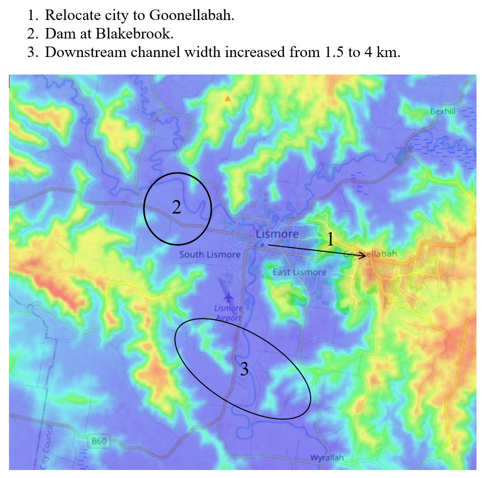
Looks by far the easiest. Why build a city at Lismore in the first place? A move of the whole city centre 4 km east to Goonellabah would be the easiest solution. Goonellabah is already well connected to the east. It would need a new major road to the south, but that’s not too difficult.
> Option 2 – Build a huge wall/berm/levee etc on either side of the river. Road and rail connections will have to go over the top of it.
Can’t be done because that would make the flood height even higher, much higher, more than double the present flood peak. High enough to overtop everything.
> Option 3 – Build a canal or tunnel or spillway etc to divert flood waters from the river around the town via another route (man-made) so floods can bypass the town.
Yes. A dam at Blakebrook would be needed. I see two ways to handle the diversion, one would skirt Lismore along the SW side of town discharging at Loftville. An alternative would be much further upstream, at Fernisde, crossing the range to connect to the stream 2.5 km south of Fernside. This stream doesn’t rejoin the Wilson River through Lismore until well south of Ruthven. A dam at Blakebrook wouldn’t divert the Wilson River flowing into Lismore from the NE. The upstream Wilson River would be much harder to divert.
Option 4 – Widen the river channel downstream of Lismore from 1.5 km to 4 km. The rock bars constricting the river downstream of Lismore are on the western side of the river south of the airport, and on the eastern side of the river NW of Wyrallah. Fingers crossed this could reduce the flood height by a factor of 3 or more.
Option 5 – Rebuild Lismore city centre on stilts. This isn’t good enough because the stilts would have to be enormously high.
mollwollfumble said:
What needs ro be done to stop Lismore ever flooding again?
Probably impossible in the fullness of time.
mollwollfumble said:
party_pants said:
mollwollfumble said:
What needs ro be done to stop Lismore ever flooding again?
Option 1 – Move the city to higher ground and rebuild it, away from the river. It seems to be in built in a low-laying bowl along the river
Option 2 – Build a huge wall/berm/levee etc on either side of the river. Road and rail connections will have to go over the top of it.
Option 3 – Build a canal or tunnel or spillway etc to divert flood waters from the river around the town via another route (man-made) so floods can bypass the town.Good answer!
> I mumbled the other day in chat that the Feds knocking back Lismore for flood mitigation works last year doesn’t look good this end. I also mentioned that the flood peak of 2.5 metres over the previous record probably wasn’t even in the planning for those works.
“the flood peak of 2.5 metres over the previous record probably wasn’t even in the planning for those works.” I agree.
There are several troubles with Lismore. The flood peak at Lismore is four times the height of Lismore above sea level. When coupled with Lismore being a long way from the coast, this spells trouble.
> Option 1 – Move the city to higher ground and rebuild it, away from the river. It seems to be in built in a low-laying bowl along the river
Looks by far the easiest. Why build a city at Lismore in the first place? A move of the whole city centre 4 km east to Goonellabah would be the easiest solution. Goonellabah is already well connected to the east. It would need a new major road to the south, but that’s not too difficult.
> Option 2 – Build a huge wall/berm/levee etc on either side of the river. Road and rail connections will have to go over the top of it.
Can’t be done because that would make the flood height even higher, much higher, more than double the present flood peak. High enough to overtop everything.
> Option 3 – Build a canal or tunnel or spillway etc to divert flood waters from the river around the town via another route (man-made) so floods can bypass the town.
Yes. A dam at Blakebrook would be needed. I see two ways to handle the diversion, one would skirt Lismore along the SW side of town discharging at Loftville. An alternative would be much further upstream, at Fernisde, crossing the range to connect to the stream 2.5 km south of Fernside. This stream doesn’t rejoin the Wilson River through Lismore until well south of Ruthven. A dam at Blakebrook wouldn’t divert the Wilson River flowing into Lismore from the NE. The upstream Wilson River would be much harder to divert.
Option 4 – Widen the river channel downstream of Lismore from 1.5 km to 4 km. The rock bars constricting the river downstream of Lismore are on the western side of the river south of the airport, and on the eastern side of the river NW of Wyrallah. Fingers crossed this could reduce the flood height by a factor of 3 or more.
Option 5 – Rebuild Lismore city centre on stilts. This isn’t good enough because the stilts would have to be enormously high.
I must admit to not knowing any of the detail of the region. I looked at it on GE and paid particular attention to the elevations. It looks like the town was built at the confluence of two rivers, which in milder climate regimes like Europe or North America is a logical place to build a settlement. But the extremes of eastern Australia just make it a bad choice of spot.
Not the first time that a town has had to be moved and rebuilt after natural disasters. Onslow in WA was moved and rebuilt in a more suitable location. It was at the mouth of a river (once again a logical spot in more favourable climates) but it suffered floods whenever a tropical cyclone hit the area.
I mean… at the risk of stating the obv
… the town is built on a flood plain.
dv said:
I mean… at the risk of stating the obv
… the town is built on a flood plain.
Slow down, Poindexter.
https://www.abc.net.au/news/2022-03-06/nsw-floods-how-a-spreadsheet-became-lifesaver-in-lismore/100885054
dv said:
I mean… at the risk of stating the obv
… the town is built on a flood plain.
At the risk of stating the obvious, there is a difference between “built on a flood plain” and “built under 16 metres of water”.
SCIENCE said:
If you must use atomics, use them against the rock wall south of Lismore airport. The rock wall that is forming a natural dam with Lismore in the middle.
From Frank Herbert, Dune, “The language of the Great Convention is clear enough: use of atomics against humans shall be cause for planetary obliteration. We’re going to blast the shield wall, not humans”.
party_pants said:
Not the first time that a town has had to be moved and rebuilt after natural disasters. Onslow in WA was moved and rebuilt in a more suitable location. It was at the mouth of a river (once again a logical spot in more favourable climates) but it suffered floods whenever a tropical cyclone hit the area.
Ta, I hadn’t known that.
———-
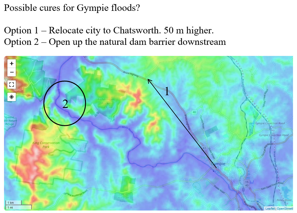
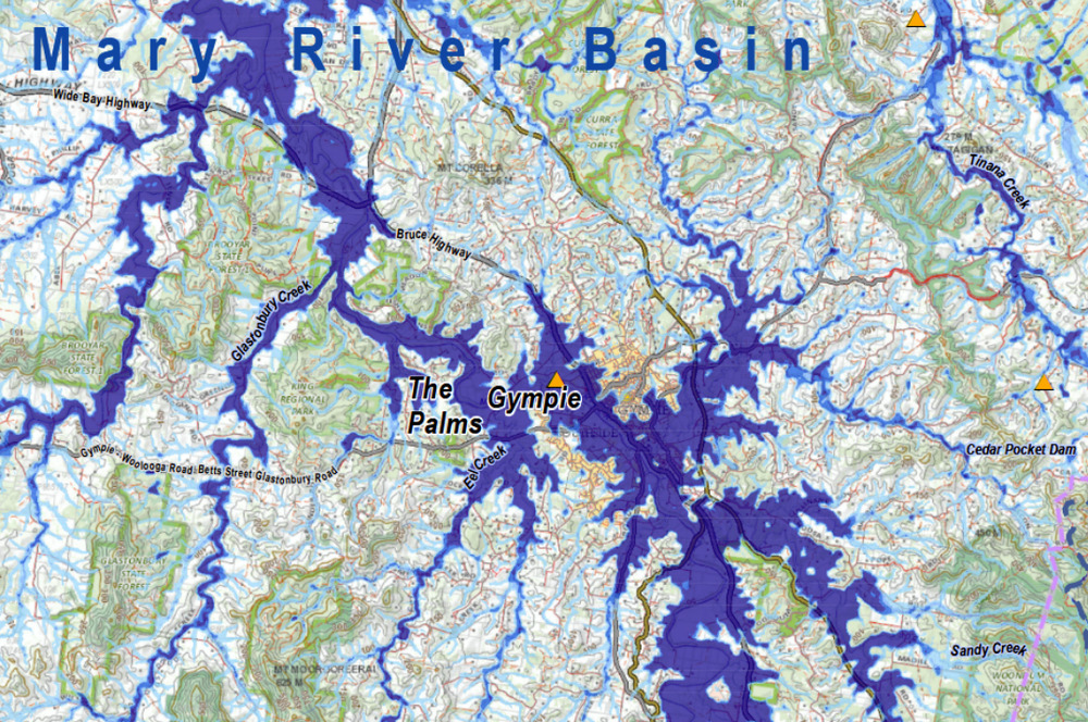
The other place very strongly affected in the recent floods was Gympie.
Option 1 – Moving Gympie 7 km north west to Chatsworth would lift it 50 metres in elevation, well above flood level, and it would still be on the main Bruce Highway.
Option 2 – Like Lismore, Gympie is built in the middle of a natural dam. The flood channel of the Mary River just downstream of the city narrows to just 500 metres across. This could be widened, but probably to no more than 1 km.
Option 3 – There could be a dam placed upstream, across where Gympie Airport now is. But there’s no easy way to divert water from there down to Noosa.
Build More Dykes(?)
All the dykes in the world couldn’t save Lismore.
Scrape out the bowl and fill it with trees and wetland wildlife.
Push the buildings up the hills a bit.
Allow the water to follow its will.
Ten years ago Grantham moved to higher ground to avoid future floods. Now, after staying dry during this year’s onslaught, experts say the land swap worked. So is it time to consider replicating it? https://www.abc.net.au/news/2022-03-13/grantham-land-swap-a-model-for-future/100902758
https://www.thesaturdaypaper.com.au/news/politics/2022/03/12/the-baby-trapped-mud-24-hours-after-the-nsw-floods/164700360013488
roughbarked said:
Ten years ago Grantham moved to higher ground to avoid future floods. Now, after staying dry during this year’s onslaught, experts say the land swap worked. So is it time to consider replicating it? https://www.abc.net.au/news/2022-03-13/grantham-land-swap-a-model-for-future/100902758
Seems the local council did a great job there. To have people moving to a new home within a year is really impressive.
The Rev Dodgson said:
roughbarked said:
Ten years ago Grantham moved to higher ground to avoid future floods. Now, after staying dry during this year’s onslaught, experts say the land swap worked. So is it time to consider replicating it? https://www.abc.net.au/news/2022-03-13/grantham-land-swap-a-model-for-future/100902758
Seems the local council did a great job there. To have people moving to a new home within a year is really impressive.
“…experts say the land swap worked. So is it time to consider replicating it?”
It worked for Jindabyne, too.
The other place very strongly affected in the recent floods was Gympie.
Option 1 – Moving Gympie 7 km north west to Chatsworth would lift it 50 metres in elevation, well above flood level, and it would still be on the main Bruce Highway.
Option 2 – Like Lismore, Gympie is built in the middle of a natural dam. The flood channel of the Mary River just downstream of the city narrows to just 500 metres across. This could be widened, but probably to no more than 1 km.
Option 3 – There could be a dam placed upstream, across where Gympie Airport now is. But there’s no easy way to divert water from there down to Noosa.
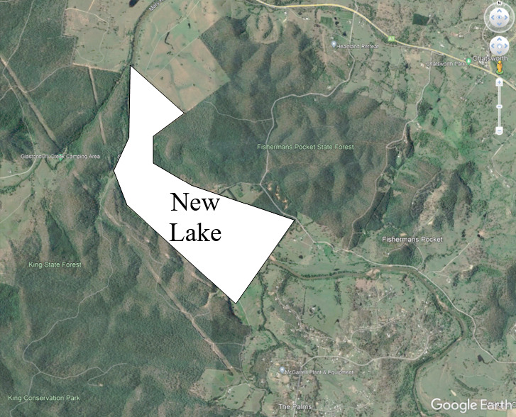
Look at location 2 in the above topography figure for Gympie. I realised that I can stop the flooding of Gympie, perhaps completely, using a trick that I leaned from my professor. Prof Colin Apelt was head of the Uni Qld department of Civil Engineering while I was doing a PhD under him in Civil Engineering. He had a system which he invented called the “minimum energy loss culvert” which is designed to minimise flooding upstream of a channel narrowing. It’s very very simple.
Applied to Gympie, all you need to do is lower the bed of the Mary River through the natural constriction downstream of Gympie.
For instance, lowering the bed by 10 metres downstream of Gympie will result in a 10 metre reduction in flood height at Gympie.
It’s not a linear relationship, for instance lowering the bed of the Mary River through the constriction by 20 metres will only give an effect similar to that of lowering the bed by 10 metres.
An advantage of this design is that the change is hardly visible on the surface. Instead of an area of grass you see a lake. Minimal environmental impact.
In the following, the channel deepening resulting in the new lake is shown on the bottom image, which is an enlargement of Area 2 in the above image
Similar bed deepening could be done downstream of Lismore but would be less effective, because the narrowing there is only to a width of 1.5 km as against 0.5 km for Gympie. But it could be done at Lismore in conjunction with the removal of the rock ridge south of Lismore airport.
…and eventually relocate to Mount Ararat?
Sorry for being a bit glib about the situation…butt…
President Al Gore warned that it would be “pennies on the dollar”
to switch over to renewable energy sources compared to the cost
of mitigating the flooding “once the birds came home to roost”.
They labeled him “An Alarmist” and overturned his rightful election
in favour of THE Pinheaded son-of-an-oil billionaire and together
with VICE President Darth Invader chose to Create a War in order
to STEAL more fossil fuel, and eventually yoke us with FRACKING.
With respect, I think you all need a bit more familiarity with the geography, topography and hydrology of Lismore. I doubt any of you can comprehend the volume of water that came down that river, and from where it came.
Firstly, Lismore’s current flood mitigation systems and engineering was put in place in 2005. All the hydrology was calculated and the system, which included the levee and raising of some houses in South Lismore, works exactly as designed and specified.
Every flood prone property in Lismore has publicly available floor height and middle of the road AHD flood levels publicly available.
The current engineering caters for the 1 in 10 year flood. Not the 1 in 100 or, this latest one, 1 in 1000.
The levee is designed so that there are specific overflow points (a little lower than the rest of the levee) where it will overflow, flow through a large carpark, and into a basin of parkland and footy fields on the other side of the CBD. It was designed to give additional time to evacuate during predictions that the levee will overflow.
It was predicted that the levee could possibly overflow 18 – 24 hours before it did. Warnings include door to door, heavy media promotion, documented evacuation routes and flood sirens.
Something for you to do. Go find out how large the area is for the catchment of the Wilson River above Lismore, Then compare it, and mark it on a map of NSW or the entire country. This will surprise you. The area is relatively small.
Further flood mitigation engineering is currently underway, to build diversion a channel from above Lismore to take flood water out and around the back of the airport. This is not yet complete.
Additionally, any new development in Lismore (last 25 years or so) must have it’s floor heights above the 1 – 100 year flood levels (eg 1954 and 1974, 2017). This includes development in the industrial areas of South Lismore, where any new development must have the land raised to above the 1 in 100 flood level. The likes off Bunnings and the airport terminal building are built on raised land.
New developments in the CBD must have floor heights above the 1 in 100 level. eg Officeworks. All carpark underneath.
The major shopping centre was built outside the CBD, on the other side of the flood basin, and again, is all carpark underneath it. and above the 1 in 100 level.
Suffice to say, that all the 1 – 100 mitigation and developments went under.
This flood was 2 metres above what was thought to be the 1 – 100 year level.
btw,
yeah, I Get It
as I said elsewhere
given the choice I chose
to relocate far from everything
I’ve known my whole life …further
from the coast and a higher elevation
my other point being
research …so as not to vote for greedy pin heads
some good pics
https://www.facebook.com/MediaMode/photos/pcb.5041887162529345/5042406909144037/
Woodie said:
With respect, I think you all need a bit more familiarity with the geography, topography and hydrology of Lismore. I doubt any of you can comprehend the volume of water that came down that river, and from where it came.Firstly, Lismore’s current flood mitigation systems and engineering was put in place in 2005. All the hydrology was calculated and the system, which included the levee and raising of some houses in South Lismore, works exactly as designed and specified.
Every flood prone property in Lismore has publicly available floor height and middle of the road AHD flood levels publicly available.
The current engineering caters for the 1 in 10 year flood. Not the 1 in 100 or, this latest one, 1 in 1000.
The levee is designed so that there are specific overflow points (a little lower than the rest of the levee) where it will overflow, flow through a large carpark, and into a basin of parkland and footy fields on the other side of the CBD. It was designed to give additional time to evacuate during predictions that the levee will overflow.
It was predicted that the levee could possibly overflow 18 – 24 hours before it did. Warnings include door to door, heavy media promotion, documented evacuation routes and flood sirens.
Something for you to do. Go find out how large the area is for the catchment of the Wilson River above Lismore, Then compare it, and mark it on a map of NSW or the entire country. This will surprise you. The area is relatively small.
Further flood mitigation engineering is currently underway, to build diversion a channel from above Lismore to take flood water out and around the back of the airport. This is not yet complete.
Additionally, any new development in Lismore (last 25 years or so) must have it’s floor heights above the 1 – 100 year flood levels (eg 1954 and 1974, 2017). This includes development in the industrial areas of South Lismore, where any new development must have the land raised to above the 1 in 100 flood level. The likes off Bunnings and the airport terminal building are built on raised land.
New developments in the CBD must have floor heights above the 1 in 100 level. eg Officeworks. All carpark underneath.
The major shopping centre was built outside the CBD, on the other side of the flood basin, and again, is all carpark underneath it. and above the 1 in 100 level.
Suffice to say, that all the 1 – 100 mitigation and developments went under.
This flood was 2 metres above what was thought to be the 1 – 100 year level.
Yeah we know that. However, my question always was, which engineers weren’t listened to whe Lismore was being built?
All of these towns and cities on rivers may have been OK in England but never in Australia and they have had ages to fix the fucker. Why are they suddenly complaining now?
roughbarked said:
Woodie said:
With respect, I think you all need a bit more familiarity with the geography, topography and hydrology of Lismore. I doubt any of you can comprehend the volume of water that came down that river, and from where it came.Firstly, Lismore’s current flood mitigation systems and engineering was put in place in 2005. All the hydrology was calculated and the system, which included the levee and raising of some houses in South Lismore, works exactly as designed and specified.
Every flood prone property in Lismore has publicly available floor height and middle of the road AHD flood levels publicly available.
The current engineering caters for the 1 in 10 year flood. Not the 1 in 100 or, this latest one, 1 in 1000.
The levee is designed so that there are specific overflow points (a little lower than the rest of the levee) where it will overflow, flow through a large carpark, and into a basin of parkland and footy fields on the other side of the CBD. It was designed to give additional time to evacuate during predictions that the levee will overflow.
It was predicted that the levee could possibly overflow 18 – 24 hours before it did. Warnings include door to door, heavy media promotion, documented evacuation routes and flood sirens.
Something for you to do. Go find out how large the area is for the catchment of the Wilson River above Lismore, Then compare it, and mark it on a map of NSW or the entire country. This will surprise you. The area is relatively small.
Further flood mitigation engineering is currently underway, to build diversion a channel from above Lismore to take flood water out and around the back of the airport. This is not yet complete.
Additionally, any new development in Lismore (last 25 years or so) must have it’s floor heights above the 1 – 100 year flood levels (eg 1954 and 1974, 2017). This includes development in the industrial areas of South Lismore, where any new development must have the land raised to above the 1 in 100 flood level. The likes off Bunnings and the airport terminal building are built on raised land.
New developments in the CBD must have floor heights above the 1 in 100 level. eg Officeworks. All carpark underneath.
The major shopping centre was built outside the CBD, on the other side of the flood basin, and again, is all carpark underneath it. and above the 1 in 100 level.
Suffice to say, that all the 1 – 100 mitigation and developments went under.
This flood was 2 metres above what was thought to be the 1 – 100 year level.
Yeah we know that. However, my question always was, which engineers weren’t listened to whe Lismore was being built?
All of these towns and cities on rivers may have been OK in England but never in Australia and they have had ages to fix the fucker. Why are they suddenly complaining now?
you know they do get floods in england? some have been fairly bad.
Bogsnorkler said:
roughbarked said:
Woodie said:
With respect, I think you all need a bit more familiarity with the geography, topography and hydrology of Lismore. I doubt any of you can comprehend the volume of water that came down that river, and from where it came.Firstly, Lismore’s current flood mitigation systems and engineering was put in place in 2005. All the hydrology was calculated and the system, which included the levee and raising of some houses in South Lismore, works exactly as designed and specified.
Every flood prone property in Lismore has publicly available floor height and middle of the road AHD flood levels publicly available.
The current engineering caters for the 1 in 10 year flood. Not the 1 in 100 or, this latest one, 1 in 1000.
The levee is designed so that there are specific overflow points (a little lower than the rest of the levee) where it will overflow, flow through a large carpark, and into a basin of parkland and footy fields on the other side of the CBD. It was designed to give additional time to evacuate during predictions that the levee will overflow.
It was predicted that the levee could possibly overflow 18 – 24 hours before it did. Warnings include door to door, heavy media promotion, documented evacuation routes and flood sirens.
Something for you to do. Go find out how large the area is for the catchment of the Wilson River above Lismore, Then compare it, and mark it on a map of NSW or the entire country. This will surprise you. The area is relatively small.
Further flood mitigation engineering is currently underway, to build diversion a channel from above Lismore to take flood water out and around the back of the airport. This is not yet complete.
Additionally, any new development in Lismore (last 25 years or so) must have it’s floor heights above the 1 – 100 year flood levels (eg 1954 and 1974, 2017). This includes development in the industrial areas of South Lismore, where any new development must have the land raised to above the 1 in 100 flood level. The likes off Bunnings and the airport terminal building are built on raised land.
New developments in the CBD must have floor heights above the 1 in 100 level. eg Officeworks. All carpark underneath.
The major shopping centre was built outside the CBD, on the other side of the flood basin, and again, is all carpark underneath it. and above the 1 in 100 level.
Suffice to say, that all the 1 – 100 mitigation and developments went under.
This flood was 2 metres above what was thought to be the 1 – 100 year level.
Yeah we know that. However, my question always was, which engineers weren’t listened to whe Lismore was being built?
All of these towns and cities on rivers may have been OK in England but never in Australia and they have had ages to fix the fucker. Why are they suddenly complaining now?
you know they do get floods in england? some have been fairly bad.
Yeah but..
roughbarked said:
Bogsnorkler said:
roughbarked said:Yeah we know that. However, my question always was, which engineers weren’t listened to whe Lismore was being built?
All of these towns and cities on rivers may have been OK in England but never in Australia and they have had ages to fix the fucker. Why are they suddenly complaining now?
you know they do get floods in england? some have been fairly bad.
Yeah but..
You know they are different.
roughbarked said:
roughbarked said:
Bogsnorkler said:you know they do get floods in england? some have been fairly bad.
Yeah but..
You know they are different.
Bogsnorkler said:
roughbarked said:
Woodie said:
With respect, I think you all need a bit more familiarity with the geography, topography and hydrology of Lismore. I doubt any of you can comprehend the volume of water that came down that river, and from where it came.Firstly, Lismore’s current flood mitigation systems and engineering was put in place in 2005. All the hydrology was calculated and the system, which included the levee and raising of some houses in South Lismore, works exactly as designed and specified.
Every flood prone property in Lismore has publicly available floor height and middle of the road AHD flood levels publicly available.
The current engineering caters for the 1 in 10 year flood. Not the 1 in 100 or, this latest one, 1 in 1000.
The levee is designed so that there are specific overflow points (a little lower than the rest of the levee) where it will overflow, flow through a large carpark, and into a basin of parkland and footy fields on the other side of the CBD. It was designed to give additional time to evacuate during predictions that the levee will overflow.
It was predicted that the levee could possibly overflow 18 – 24 hours before it did. Warnings include door to door, heavy media promotion, documented evacuation routes and flood sirens.
Something for you to do. Go find out how large the area is for the catchment of the Wilson River above Lismore, Then compare it, and mark it on a map of NSW or the entire country. This will surprise you. The area is relatively small.
Further flood mitigation engineering is currently underway, to build diversion a channel from above Lismore to take flood water out and around the back of the airport. This is not yet complete.
Additionally, any new development in Lismore (last 25 years or so) must have it’s floor heights above the 1 – 100 year flood levels (eg 1954 and 1974, 2017). This includes development in the industrial areas of South Lismore, where any new development must have the land raised to above the 1 in 100 flood level. The likes off Bunnings and the airport terminal building are built on raised land.
New developments in the CBD must have floor heights above the 1 in 100 level. eg Officeworks. All carpark underneath.
The major shopping centre was built outside the CBD, on the other side of the flood basin, and again, is all carpark underneath it. and above the 1 in 100 level.
Suffice to say, that all the 1 – 100 mitigation and developments went under.
This flood was 2 metres above what was thought to be the 1 – 100 year level.
Yeah we know that. However, my question always was, which engineers weren’t listened to whe Lismore was being built?
All of these towns and cities on rivers may have been OK in England but never in Australia and they have had ages to fix the fucker. Why are they suddenly complaining now?
you know they do get floods in england? some have been fairly bad.
The year was two thousand and ten, I was about five miles out of Monmouth heading to Pandy and had stopped in a field beside a little brook to have lunch.
My last entry in my little tape recorder was “Been a nice day so far, could rain later by the looks of things”
Bogsnorkler said:
roughbarked said:
roughbarked said:Yeah but..
You know they are different.
In that case the same stupid engineers came here then.
In school, I recall sitting looking out the window watching the rain fall and make the various aspects of rivers from rushing to meanderiing and including spreading out as deltas. Whack, the fucktard schol principal gives me yet another cuff to the ears or a knuckle to the temple from behind.
After all, the other people were supposed to be reading it from a book. I was simply observing it after I had finished reading it from the book.
roughbarked said:
In school, I recall sitting looking out the window watching the rain fall and make the various aspects of rivers from rushing to meanderiing and including spreading out as deltas. Whack, the fucktard schol principal gives me yet another cuff to the ears or a knuckle to the temple from behind.
After all, the other people were supposed to be reading it from a book. I was simply observing it after I had finished reading it from the book.
My grade 6 teacher called me ‘cloud 99’ due to my vaguing off and staring out the window. Yes. The man with the ladder was more interesting.
sarahs mum said:
roughbarked said:
In school, I recall sitting looking out the window watching the rain fall and make the various aspects of rivers from rushing to meanderiing and including spreading out as deltas. Whack, the fucktard schol principal gives me yet another cuff to the ears or a knuckle to the temple from behind.
After all, the other people were supposed to be reading it from a book. I was simply observing it after I had finished reading it from the book.
My grade 6 teacher called me ‘cloud 99’ due to my vaguing off and staring out the window. Yes. The man with the ladder was more interesting.
I recall a woman whose own brother was away further than myself, refer to me as off with the fairies at the bottom of the garden. She of course was correct about everything other than the fairies.
roughbarked said:
sarahs mum said:
roughbarked said:
In school, I recall sitting looking out the window watching the rain fall and make the various aspects of rivers from rushing to meanderiing and including spreading out as deltas. Whack, the fucktard schol principal gives me yet another cuff to the ears or a knuckle to the temple from behind.
After all, the other people were supposed to be reading it from a book. I was simply observing it after I had finished reading it from the book.
My grade 6 teacher called me ‘cloud 99’ due to my vaguing off and staring out the window. Yes. The man with the ladder was more interesting.
I recall a woman whose own brother was away further than myself, refer to me as off with the fairies at the bottom of the garden. She of course was correct about everything other than the fairies.
used to tick them off when they’d tell me to repeat what they’d be saying I could
…looking else where, or even drawing seemed to open my brain to learning and
remembering much more so than following along with words on a printed page.
like I said, used to make the teacher awfully mad
Ogmog said:
roughbarked said:
sarahs mum said:My grade 6 teacher called me ‘cloud 99’ due to my vaguing off and staring out the window. Yes. The man with the ladder was more interesting.
I recall a woman whose own brother was away further than myself, refer to me as off with the fairies at the bottom of the garden. She of course was correct about everything other than the fairies.
used to tick them off when they’d tell me to repeat what they’d be saying I could
…looking else where, or even drawing seemed to open my brain to learning and
remembering much more so than following along with words on a printed page.like I said, used to make the teacher awfully mad
This excellent mark does not reflect the amount of work Roslyn has put into this subject.
roughbarked said:
Yeah we know that. However, my question always was, which engineers weren’t listened to whe Lismore was being built?
All of these towns and cities on rivers may have been OK in England but never in Australia and they have had ages to fix the fucker. Why are they suddenly complaining now?
Yeah but no but yeah but no but yeah.
Lismore was settled approx 1850 IIRC. There were no “engineers” as such then. It was as far up the Richmond/Wilson river system as ocean going ships could navigate. The Wilson River at Lismore is tidal even though it’s 50 odd kms up the river from the mouth at Ballina. At the time, there was no other way of getting there other than ship.
Why was it settled? Timber and lots of it. Lismore is at the confluence of two “creeks”. Trees where chopped down, and floated down the creeks to Lismore, where they were fetched from the river and milled, then put on ships. The timber mills (and hence the town) had to be close to the river to be able to fetch the logs.
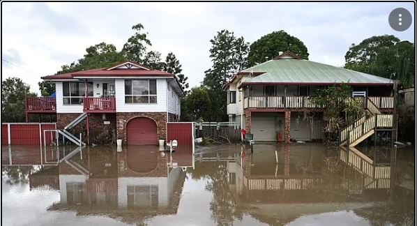
Most of lower Lismore housing is built on stilts, and is quite old. See pic.
What most people have done, is build in under the house, as extra living space, garages, laundries. lounge areas, extra storage, granny flat etc. then complain when it floods that they have lost everything. That’s for many floods prior to this one. Not even the stilts saved a lot of houses this time.
Residents also need to take some responsibility as well, for being complacent, and doing as I described, mostly without any planning permit or permission.
It’s not just an “engineers” problem.
.
Woodie said:
roughbarked said:Yeah we know that. However, my question always was, which engineers weren’t listened to whe Lismore was being built?
All of these towns and cities on rivers may have been OK in England but never in Australia and they have had ages to fix the fucker. Why are they suddenly complaining now?
Yeah but no but yeah but no but yeah.
Lismore was settled approx 1850 IIRC. There were no “engineers” as such then. It was as far up the Richmond/Wilson river system as ocean going ships could navigate. The Wilson River at Lismore is tidal even though it’s 50 odd kms up the river from the mouth at Ballina. At the time, there was no other way of getting there other than ship.
Why was it settled? Timber and lots of it. Lismore is at the confluence of two “creeks”. Trees where chopped down, and floated down the creeks to Lismore, where they were fetched from the river and milled, then put on ships. The timber mills (and hence the town) had to be close to the river to be able to fetch the logs.
Most of lower Lismore housing is built on stilts, and is quite old. See pic.
What most people have done, is build in under the house, as extra living space, garages, laundries. lounge areas, extra storage, granny flat etc. then complain when it floods that they have lost everything. That’s for many floods prior to this one. Not even the stilts saved a lot of houses this time.
Residents also need to take some responsibility as well, for being complacent, and doing as I described, mostly without any planning permit or permission.
It’s not just an “engineers” problem.
.
Hindsight is a wonderful thing. Also assuming today’s level of knowledge over 150 years ago.
buffy said:
Woodie said:
roughbarked said:Yeah we know that. However, my question always was, which engineers weren’t listened to whe Lismore was being built?
All of these towns and cities on rivers may have been OK in England but never in Australia and they have had ages to fix the fucker. Why are they suddenly complaining now?
Yeah but no but yeah but no but yeah.
Lismore was settled approx 1850 IIRC. There were no “engineers” as such then. It was as far up the Richmond/Wilson river system as ocean going ships could navigate. The Wilson River at Lismore is tidal even though it’s 50 odd kms up the river from the mouth at Ballina. At the time, there was no other way of getting there other than ship.
Why was it settled? Timber and lots of it. Lismore is at the confluence of two “creeks”. Trees where chopped down, and floated down the creeks to Lismore, where they were fetched from the river and milled, then put on ships. The timber mills (and hence the town) had to be close to the river to be able to fetch the logs.
Most of lower Lismore housing is built on stilts, and is quite old. See pic.
What most people have done, is build in under the house, as extra living space, garages, laundries. lounge areas, extra storage, granny flat etc. then complain when it floods that they have lost everything. That’s for many floods prior to this one. Not even the stilts saved a lot of houses this time.
Residents also need to take some responsibility as well, for being complacent, and doing as I described, mostly without any planning permit or permission.
It’s not just an “engineers” problem.
.
Hindsight is a wonderful thing. Also assuming today’s level of knowledge over 150 years ago.
Pfffft The Ancients knew!
Lismore flood history.
https://lismore.nsw.gov.au/files/Lismore_Flood_Events_1870-2017.pdf
An interesting look.
River levels were estimated at 14.5 metres. Estimated?? Yep. The gauge broke. Way off the top of the chart in that PDF.
Again
it wasn’t engineers from other countries that were at fault
as much as the lack of anticipation that the climate could
or would change within the space of a couple generations
The Dutch engineered dikes, and New Orleans built levies
and the Venitians built canals, all 3 were at or beneath sea
level and until recently it wasn’t an issue… they just had no
way of knowing that we could screw everything up so fast.
Woodie said:
Lismore flood history.https://lismore.nsw.gov.au/files/Lismore_Flood_Events_1870-2017.pdf
An interesting look.
River levels were estimated at 14.5 metres. Estimated?? Yep. The gauge broke. Way off the top of the chart in that PDF.
Thanks for that.
Bogsnorkler said:
buffy said:
Woodie said:Yeah but no but yeah but no but yeah.
Lismore was settled approx 1850 IIRC. There were no “engineers” as such then. It was as far up the Richmond/Wilson river system as ocean going ships could navigate. The Wilson River at Lismore is tidal even though it’s 50 odd kms up the river from the mouth at Ballina. At the time, there was no other way of getting there other than ship.
Why was it settled? Timber and lots of it. Lismore is at the confluence of two “creeks”. Trees where chopped down, and floated down the creeks to Lismore, where they were fetched from the river and milled, then put on ships. The timber mills (and hence the town) had to be close to the river to be able to fetch the logs.
Most of lower Lismore housing is built on stilts, and is quite old. See pic.
What most people have done, is build in under the house, as extra living space, garages, laundries. lounge areas, extra storage, granny flat etc. then complain when it floods that they have lost everything. That’s for many floods prior to this one. Not even the stilts saved a lot of houses this time.
Residents also need to take some responsibility as well, for being complacent, and doing as I described, mostly without any planning permit or permission.
It’s not just an “engineers” problem.
.
Hindsight is a wonderful thing. Also assuming today’s level of knowledge over 150 years ago.
Pfffft The Ancients knew!
The Europeans neglected to consult the Ancients when they came here…
buffy said:
Woodie said:
roughbarked said:Yeah we know that. However, my question always was, which engineers weren’t listened to whe Lismore was being built?
All of these towns and cities on rivers may have been OK in England but never in Australia and they have had ages to fix the fucker. Why are they suddenly complaining now?
Yeah but no but yeah but no but yeah.
Lismore was settled approx 1850 IIRC. There were no “engineers” as such then. It was as far up the Richmond/Wilson river system as ocean going ships could navigate. The Wilson River at Lismore is tidal even though it’s 50 odd kms up the river from the mouth at Ballina. At the time, there was no other way of getting there other than ship.
Why was it settled? Timber and lots of it. Lismore is at the confluence of two “creeks”. Trees where chopped down, and floated down the creeks to Lismore, where they were fetched from the river and milled, then put on ships. The timber mills (and hence the town) had to be close to the river to be able to fetch the logs.
Most of lower Lismore housing is built on stilts, and is quite old. See pic.
What most people have done, is build in under the house, as extra living space, garages, laundries. lounge areas, extra storage, granny flat etc. then complain when it floods that they have lost everything. That’s for many floods prior to this one. Not even the stilts saved a lot of houses this time.
Residents also need to take some responsibility as well, for being complacent, and doing as I described, mostly without any planning permit or permission.
It’s not just an “engineers” problem.
.
Hindsight is a wonderful thing. Also assuming today’s level of knowledge over 150 years ago.
They have had 150 years to fix it. They really didn’t need to stay there after the first flood.
https://www.theguardian.com/australia-news/2022/mar/14/as-the-nsw-floods-dealt-their-damage-choppers-rescued-people-from-snakebites-landslides-and-rising-water
https://www.smh.com.au/politics/nsw/baffled-pilots-say-their-helicopters-were-not-wanted-by-government-during-flood-crisis-20220312-p5a41t.html
Woodie said:
With respect, I think you all need a bit more familiarity with the geography, topography and hydrology of Lismore. I doubt any of you can comprehend the volume of water that came down that river, and from where it came.Firstly, Lismore’s current flood mitigation systems and engineering was put in place in 2005. All the hydrology was calculated and the system, which included the levee and raising of some houses in South Lismore, works exactly as designed and specified.
Every flood prone property in Lismore has publicly available floor height and middle of the road AHD flood levels publicly available.
The current engineering caters for the 1 in 10 year flood. Not the 1 in 100 or, this latest one, 1 in 1000.
The levee is designed so that there are specific overflow points (a little lower than the rest of the levee) where it will overflow, flow through a large carpark, and into a basin of parkland and footy fields on the other side of the CBD. It was designed to give additional time to evacuate during predictions that the levee will overflow.
It was predicted that the levee could possibly overflow 18 – 24 hours before it did. Warnings include door to door, heavy media promotion, documented evacuation routes and flood sirens.
Something for you to do. Go find out how large the area is for the catchment of the Wilson River above Lismore, Then compare it, and mark it on a map of NSW or the entire country. This will surprise you. The area is relatively small.
Further flood mitigation engineering is currently underway, to build diversion a channel from above Lismore to take flood water out and around the back of the airport. This is not yet complete.
Additionally, any new development in Lismore (last 25 years or so) must have it’s floor heights above the 1 – 100 year flood levels (eg 1954 and 1974, 2017). This includes development in the industrial areas of South Lismore, where any new development must have the land raised to above the 1 in 100 flood level. The likes off Bunnings and the airport terminal building are built on raised land.
New developments in the CBD must have floor heights above the 1 in 100 level. eg Officeworks. All carpark underneath.
The major shopping centre was built outside the CBD, on the other side of the flood basin, and again, is all carpark underneath it. and above the 1 in 100 level.
Suffice to say, that all the 1 – 100 mitigation and developments went under.
This flood was 2 metres above what was thought to be the 1 – 100 year level.
Thank you for that. This is not stuff that I knew in advance. I’m following it up.
For Gympie, the two maps in this report https://afrip.ga.gov.au/flood-study-web/download/resource/4852 are darn good. Huge and detailed. They cover the whole of the Mary River catchment for both 100 yr and extreme floods.
The method used is as good as possible, STRM topographic measurements followed by 2-D hydraulic modelling.
As good as possible has some flaw, however, because STRM topography has errors of +-5 metres at best and the grid is only one of 50 metres. That makles it very easy to get the wrong altitude for the river channel and possibly miss it completely.
Flooding in extreme flood near Gympie city. Note the downstream constrictions in flow to the NW of the city.
For extreme floods