Date: 14/05/2022 06:20:19
From: monkey skipper
ID: 1882994
Subject: SEQ Dam Levels

For information about flood levels, contact your local Council. For information about road impacts, contact Transport and Main Roads. For information about river levels, please see the Bureau of Meteorology website.

Dam Full supply volume (ML) Current volume (ML) % full Latest observation Comment

Atkinson
View historical dam levels 30, 401 ML 31, 905 ML 104.9% 3:54pm 13/05/2022 Dam is spilling

Baroon Pocket
View historical dam levels 61, 000 ML 65, 729 ML 107.8% 3:30am 14/05/2022 Dam is spilling

Bill Gunn (Lake Dyer)
View historical dam levels 6, 947 ML 7, 234 ML 104.1% 2:03am 14/05/2022 Dam is spilling

Borumba
View historical dam levels 46, 000 ML 51, 660 ML 112.3% 4:25am 14/05/2022 Dam is spilling

Cedar Pocket
View historical dam levels 735 ML 879 ML 119.6% 4:15am 14/05/2022 Dam is spilling

Clarendon
View historical dam levels 24, 276 ML 22, 409 ML 92.3% 4:06am 14/05/2022
Cooloolabin
View historical dam levels 8, 183 ML 9, 150 ML 111.8% 3:17am 14/05/2022 Dam is spilling

Enoggera
View historical dam levels 4, 262 ML 5, 598 ML 131.3% 4:18am 14/05/2022 Dam is spilling

Ewen Maddock
View historical dam levels 16, 587 ML 19, 043 ML 114.8% 4:00am 14/05/2022 Dam is spilling

Gold Creek
View historical dam levels 801 ML 1, 417 ML 176.9% 3:29am 14/05/2022 Dam is spilling

Hinze
View historical dam levels 310, 730 ML 330, 834 ML 106.5% 3:31am 14/05/2022 Dam is spilling

Lake Macdonald (Six Mile Creek)
View historical dam levels 8, 018 ML 9, 510 ML 118.6% 4:17am 14/05/2022 Dam is spilling

Lake Manchester
View historical dam levels 26, 217 ML 28, 198 ML 107.6% 4:20am 14/05/2022 Dam is spilling

Leslie Harrison
View historical dam levels 13, 206 ML 14, 367 ML 108.8% 3:13am 14/05/2022 Dam is spilling

Little Nerang
View historical dam levels 6, 705 ML 6, 898 ML 102.9% 3:51am 14/05/2022 Dam is spilling

Maroon
View historical dam levels 44, 319 ML 51, 094 ML 115.3% 3:04pm 13/05/2022 Releases occurring

Moogerah
View historical dam levels 83, 765 ML 100, 510 ML 120.0% 4:18am 14/05/2022 Dam is spilling

Nindooinbah
View historical dam levels 208 ML 257 ML 123.6% 3:42am 14/05/2022 Dam is spilling

North Pine (Lake Samsonvale)
View historical dam levels 214, 302 ML 145, 854 ML 68.1% 4:20am 14/05/2022 Releases occurring

Poona
View historical dam levels 655 ML 664 ML 101.4% 3:56am 14/05/2022 Dam is spilling

Sideling Creek (Lake Kurwongbah)
View historical dam levels 14, 192 ML 15, 289 ML 107.7% 3:10am 14/05/2022 Dam is spilling

Somerset
View historical dam levels 379, 849 ML 343, 807 ML 90.5% 3:40am 14/05/2022 Utilising flood storage compartment

Wappa
View historical dam levels 4, 694 ML 5, 001 ML 106.5% 4:16am 14/05/2022 Dam is spilling

Wivenhoe
View historical dam levels 1, 165, 240 ML 1, 474, 130 ML 126.5% 4:04am 14/05/2022 Utilising flood storage compartment

Wyaralong
View historical dam levels 102, 883 ML 117, 825 ML 114.5% 3:50am 14/05/2022 Dam is spilling

Note: Full supply capacity does not include the entire flood storage compartments of Wivenhoe and Somerset dams.

The current flood storage capacity
Dam Total Flood Storage Volume Percentage of Flood Storage Volume in use Percentage of Flood Storage Volume available

Somerset 705, 000 ML 5.8% 94.2%

Wivenhoe 2, 080, 000 ML 20.3% 79.7%
Reply Quote

Date: 14/05/2022 06:51:15
From: Peak Warming Man
ID: 1882997
Subject: re: SEQ Dam Levels

And through the night it pattered still,
And lightsome, gladsome elves
On dripping spout and window-sill
Kept talking to themselves.

It pelted, pelted all day long,
A-singing at its work,
Till every heart took up the song
Way out to Back-o’-Bourke.

And every creek a banker ran,
And dams filled overtop;
“We’ll all be rooned,” said Hanrahan,
“If this rain doesn’t stop.”

Reply Quote

Date: 14/05/2022 08:02:27
From: captain_spalding
ID: 1883008
Subject: re: SEQ Dam Levels

There’s also three dams which supply Toowoomba with water, which are managed by the Regional Council, and they don’t show up on the SEQ stats. Cressbrook is the largest at 81,000 megalitires.

Current combined storage is 132,000 ml, 105% capacity.

Reply Quote

Date: 14/05/2022 09:49:51
From: monkey skipper
ID: 1883051
Subject: re: SEQ Dam Levels

Flood Warning Summary
IDQ20885

Flood Summary
Issued at 8:03 am EST on Saturday 14 May 2022.

The following Watches/Warnings are current:

Major Flood Warning for the Cape River, Minor Flood Warning for the Suttor River and Flood Warning for the Burdekin River

Major Flood Warning for the Condamine and Balonne Rivers

Major Flood Warning for the Logan River

Major Flood Warning for Warrill Creek and Bremer River, Major Flood Warning for Laidley Creek, Moderate Flood Warning for the Lockyer Creek and Moderate Flood Warning for the Lower Brisbane River

Moderate Flood Warning for Eyre Creek and Flood Warning for the Georgina River

Moderate Flood Warning for the Baffle Creek and Kolan River

Moderate Flood Warning for the Burnett River

Moderate Flood Warning for the Cooper Creek and Thomson River, Minor Flood Warning for the Barcoo River

Moderate Flood Warning for the Fitzroy River Catchment

Moderate Flood Warning for the Flinders River

Moderate Flood Warning for the Macintyre River and Minor Flood Warning for the Weir River

Moderate Flood Warning for the Mary River

Moderate Flood Warning for the upper Brisbane and Stanley Rivers

Flood Warning for the Diamantina River

Final Flood Warning for the Tully River

Flood Watch for coastal catchments in parts of the Wide Bay and Burnett, and South East Queensland

Final Flood Watch for the Fitzroy Catchment and the Central and Southern interior.

Initial Minor Flood Warning for the Maroochy River

Initial Minor Flood Warning for the Paroo River (QLD)

Initial Minor Flood Warning for the Wallam Creek

Minor to Moderate Flood Warning for the Moonie River

Additional Information:

##

Warnings and River Height Bulletins are available at www.bom.gov.au/qld/flood

Reply Quote

Date: 14/05/2022 11:37:02
From: monkey skipper
ID: 1883101
Subject: re: SEQ Dam Levels

https://www.msn.com/en-au/news/australia/warwick-hit-with-worst-flooding-in-a-decade/vi-AAXdZVE?ocid=msedgntp&cvid=43a8697968f7424d889ecd4a659b4a0a

Water level higher in than 2011 but should be receding overnight in Warwick.

Reply Quote

Date: 14/05/2022 11:40:07
From: Tamb
ID: 1883102
Subject: re: SEQ Dam Levels

monkey skipper said:


https://www.msn.com/en-au/news/australia/warwick-hit-with-worst-flooding-in-a-decade/vi-AAXdZVE?ocid=msedgntp&cvid=43a8697968f7424d889ecd4a659b4a0a

Water level higher in than 2011 but should be receding overnight in Warwick.


I fortunate coming home yesterday. The local creek was across the road for 3 days & only cleared the causeway a few hours before I got to it.

Reply Quote

Date: 14/05/2022 11:58:53
From: monkey skipper
ID: 1883109
Subject: re: SEQ Dam Levels

Tamb said:


monkey skipper said:

https://www.msn.com/en-au/news/australia/warwick-hit-with-worst-flooding-in-a-decade/vi-AAXdZVE?ocid=msedgntp&cvid=43a8697968f7424d889ecd4a659b4a0a

Water level higher in than 2011 but should be receding overnight in Warwick.


I fortunate coming home yesterday. The local creek was across the road for 3 days & only cleared the causeway a few hours before I got to it.

Behold … Tamb parts the sea, well ,,,the creek!

Reply Quote

Date: 14/05/2022 12:43:22
From: monkey skipper
ID: 1883125
Subject: re: SEQ Dam Levels

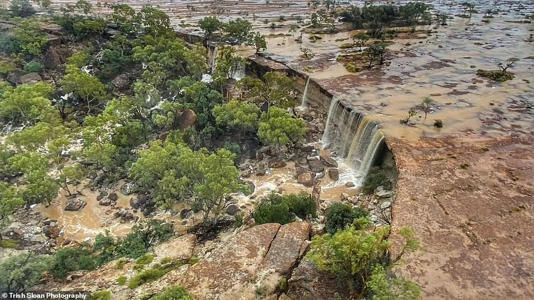
How a massive RAIN BOMB has completely transformed a bone dry Outback town
Winton, in Central West Queensland, has been smashed by torrential rain as wild weather lashes the state

The Australian Age of Dinosaurs Museum has copped 160mm since April 23, turning the site into a murky lake

Incredible photos show the typically dry outback transformed from red earth plains into a brown swamp

By TITA SMITH FOR DAILY MAIL AUSTRALIA

PUBLISHED: 18:09 AEST, 13 May 2022 | UPDATED: 18:09 AEST, 13 May 2022

A typically arid outback town in Central West Queensland was drastically transformed into a murky brown swamp after being lashed by days of torrential rain.

Incredible photos show the Australian Age of Dinosaurs Museum, located on an 1800 hectare mesa plateau near Winton, submerged underwater after recording 160mm since April 23.

Nestled in the Mitchell Grass Downs, the savanna area – 1200km northwest of Brisbane – features rolling red earth plains, with patches of spinifex and vibrant green gums.

But the plains have turned into an apocalyptic-looking lake after the state was battered by downpours, with the Dinosaur Stampede feature copping a whopping 200mm.

Before: The Australian Age of Dinosaurs Museum, in Central West Queensland, sits on a 1800 hectare plateau of red earth

After: The typically dry region has been turned into a swamp after days of torrential rain lashed the state

After: The typically dry region has been turned into a swamp after days of torrential rain lashed the state

Before: The outback region in Queensland consists of barren dusty plains and is known as the ‘Dinosaur capital of Australia’

Before: The outback region in Queensland consists of barren dusty plains and is known as the ‘Dinosaur capital of Australia’

After: Museum employee Trish Sloan said she has never seen so much water in the typically dry area

Birds-eye view images taken by museum employee Trish Sloan shows kilometres of water, dyed sepia from the dirt.

Ms Sloan said there has been no reported damage to the museum itself so far, but the wild conditions have blocked off access to the site.

Summer is OVER: Chilly blast is set to hit Australia this…

Weather expert predicts rare combination of events not…

Wettest day this century dumps more than 100mm of rain on…

‘We just can’t get to it,’ she told 9News.

Ms Sloan said it was ‘unreal’ to see so much water in the dry region.

Reply Quote

Date: 14/05/2022 12:46:49
From: monkey skipper
ID: 1883126
Subject: re: SEQ Dam Levels

Reply Quote

Date: 14/05/2022 12:48:05
From: The Rev Dodgson
ID: 1883127
Subject: re: SEQ Dam Levels

I was about to say that was a very strange picture.

Then I read the text underneath it.

monkey skipper said:


How a massive RAIN BOMB has completely transformed a bone dry Outback town
Winton, in Central West Queensland, has been smashed by torrential rain as wild weather lashes the state

The Australian Age of Dinosaurs Museum has copped 160mm since April 23, turning the site into a murky lake

Incredible photos show the typically dry outback transformed from red earth plains into a brown swamp

By TITA SMITH FOR DAILY MAIL AUSTRALIA

PUBLISHED: 18:09 AEST, 13 May 2022 | UPDATED: 18:09 AEST, 13 May 2022

A typically arid outback town in Central West Queensland was drastically transformed into a murky brown swamp after being lashed by days of torrential rain.

Incredible photos show the Australian Age of Dinosaurs Museum, located on an 1800 hectare mesa plateau near Winton, submerged underwater after recording 160mm since April 23.

Nestled in the Mitchell Grass Downs, the savanna area – 1200km northwest of Brisbane – features rolling red earth plains, with patches of spinifex and vibrant green gums.

But the plains have turned into an apocalyptic-looking lake after the state was battered by downpours, with the Dinosaur Stampede feature copping a whopping 200mm.

Before: The Australian Age of Dinosaurs Museum, in Central West Queensland, sits on a 1800 hectare plateau of red earth

After: The typically dry region has been turned into a swamp after days of torrential rain lashed the state

After: The typically dry region has been turned into a swamp after days of torrential rain lashed the state

Before: The outback region in Queensland consists of barren dusty plains and is known as the ‘Dinosaur capital of Australia’

Before: The outback region in Queensland consists of barren dusty plains and is known as the ‘Dinosaur capital of Australia’

After: Museum employee Trish Sloan said she has never seen so much water in the typically dry area

Birds-eye view images taken by museum employee Trish Sloan shows kilometres of water, dyed sepia from the dirt.

Ms Sloan said there has been no reported damage to the museum itself so far, but the wild conditions have blocked off access to the site.

Summer is OVER: Chilly blast is set to hit Australia this…

Weather expert predicts rare combination of events not…

Wettest day this century dumps more than 100mm of rain on…

‘We just can’t get to it,’ she told 9News.

Ms Sloan said it was ‘unreal’ to see so much water in the dry region.

Reply Quote

Date: 14/05/2022 12:48:16
From: Bubblecar
ID: 1883128
Subject: re: SEQ Dam Levels

monkey skipper said:


Wonder how often that happens.

Reply Quote

Date: 14/05/2022 12:50:36
From: monkey skipper
ID: 1883129
Subject: re: SEQ Dam Levels

Bubblecar said:


monkey skipper said:


Wonder how often that happens.

Quite spectacular!

I wonder if this will become the new norm?

Reply Quote

Date: 14/05/2022 13:10:20
From: buffy
ID: 1883136
Subject: re: SEQ Dam Levels

According to a quick Google search, Winton flooded in 2019 too.

Reply Quote

Date: 14/05/2022 13:14:51
From: buffy
ID: 1883138
Subject: re: SEQ Dam Levels

Oh, it looks like it’s not unusual. From Wikipedia:

>> annual totals above 1,000 millimetres or 40 inches occurred in 1950, 1974 and 2000, whereas less than 90 millimetres or 3.5 inches fell in 1905 and 2002. <<

So it’s sort of variable extremes…

Reply Quote

Date: 21/05/2022 07:32:45
From: monkey skipper
ID: 1885725
Subject: re: SEQ Dam Levels

Floods to isolate two southwest Qld towns
Fraser Barton and Marty Silk – Yesterday 4:00 pm

Hundreds of locals in Dirranbandi, Hebel and rural properties in southwest Queensland are preparing to be isolated indefinitely by floodwaters as a wet weekend is forecast for parts of Queensland.

The Bureau of Meteorology has issued further flood warnings for already inundated Queensland.

The Bureau of Meteorology has issued major flood warnings for the Balonne, Condamine and Moonie rivers, as well as Cooper and Eyre Creeks.

The forecaster says rain forecast to hit catchments across southern and central Queensland from Friday afternoon could trigger further flooding this weekend.

In the state’s southwest, Balonne Shire Council and Queensland Fire and Emergency Services issued an emergency alert for 640 locals in Dirranbandi and 67 residents in Hebel.

The BOM is forecasting the Balonne River to hit a moderate flood level of 4.3 metres at Dirranbandi on Friday and continue rising, cutting the Castlereagh Highway into the town.

“Residents may be isolated for a period of time and are advised to make preparations as required,” QFES said in an alert on Friday morning.

The BOM has placed 22 major waterways on flood watch between Rockhampton and northern Brisbane, including the Brisbane, Boyne, Calliope, Burnett, Mary, Noosa and Pine rivers – ahead of Friday’s predicted downpours.

Major flood warnings in place for parts of south east Queensland

In eastern Queensland, a flood watch has been issued for catchments between Sarina to Caboolture as they’re likely to respond to further rainfall after the past month’s deluge.

“Thunderstorms are also possible for central and eastern parts, contracting to coastal areas near Mackay and Rockhampton by Saturday,” senior meteorologist Steven Hadley said.

“The highest rainfall totals are expected in coastal areas from the Sunshine Coast to just south of Mackay.”

A risk of flash flooding remains due to thunderstorms between Proserpine and Hervey Bay which may lead to river level rises in saturated catchments.

With catchments already soaked after last weekend’s deadly floods, the BOM said minor flooding, which could disrupt local transport, is possible.

Utility and dam operator Seqwater said minor flood releases from Somerset Dam into Wivenhoe Dam on the upper Brisbane River were underway on Friday morning.

It said flood releases from both dams may need to be stepped up depending on the amount of rainfall this weekend.

Seqwater said Colleges Crossing, Burtons Bridge and Kholo Bridge were still flooded, while Mt Crosby Weir was closed.

“If you are downstream of the dam, stay away from fast flowing or deep water near waterways and floodplains,” the operator said in a statement.

Reply Quote

Date: 21/05/2022 07:39:06
From: monkey skipper
ID: 1885726
Subject: re: SEQ Dam Levels

Dam Full supply volume (ML) Current volume (ML) % full Latest observation

Atkinson

View historical dam levels 30, 401 ML 31, 222 ML 102.7% 6:00am 21/05/2022 Dam is spilling

Baroon Pocket

View historical dam levels 61, 000 ML 61, 837 ML 101.4% 6:00am 21/05/2022 Dam is spilling

Bill Gunn (Lake Dyer)

View historical dam levels 6, 947 ML 7, 011 ML 100.9% 6:00am 21/05/2022 Dam is spilling

Borumba

View historical dam levels 46, 000 ML 46, 685 ML 101.5% 6:00am 21/05/2022 Dam is spilling

Cedar Pocket

View historical dam levels 735 ML 760 ML 103.4% 6:00am 21/05/2022 Dam is spilling

Clarendon

View historical dam levels 24, 276 ML 24, 010 ML 98.9% 5:30am 21/05/2022

Cooloolabin

View historical dam levels 8, 183 ML 8, 283 ML 101.2% 6:17am 21/05/2022 Dam is spilling

Enoggera

View historical dam levels 4, 262 ML 4, 451 ML 104.4% 2:42am 21/05/2022 Dam is spilling

Ewen Maddock

View historical dam levels 16, 587 ML 17, 017 ML 102.6% 6:00am 21/05/2022 Dam is spilling

Gold Creek

View historical dam levels 801 ML 955 ML 119.2% 6:17am 21/05/2022 Dam is spilling

Hinze

View historical dam levels 310, 730 ML 329, 561 ML 106.1% 6:00am 21/05/2022 Dam is spilling

Lake Macdonald (Six Mile Creek)

View historical dam levels 8, 018 ML 8, 387 ML 104.6% 6:00am 21/05/2022 Dam is spilling

Lake Manchester

View historical dam levels 26, 217 ML 26, 431 ML 100.8% 6:11am 21/05/2022 Dam is spilling

Leslie Harrison

View historical dam levels 13, 206 ML 13, 430 ML 101.7% 6:00am 21/05/2022 Dam is spilling

Little Nerang

View historical dam levels 6, 705 ML 6, 761 ML 100.8% 6:00am 21/05/2022 Dam is spilling

Maroon

View historical dam levels 44, 319 ML 44, 464 ML 100.3% 6:00am 21/05/2022 Releases occurring

Moogerah

View historical dam levels 83, 765 ML 86, 397 ML 103.1% 6:00am 21/05/2022 Dam is spilling

Nindooinbah
View historical dam levels 208 ML 258 ML 124.0% 6:00am 21/05/2022 Dam is spilling

North Pine (Lake Samsonvale)

View historical dam levels 214, 302 ML 145, 273 ML 67.8% 6:00am 21/05/2022

Poona

View historical dam levels 655 ML 629 ML 96.0% 6:00am 21/05/2022

Sideling Creek (Lake Kurwongbah)

View historical dam levels 14, 192 ML 14, 370 ML 101.3% 6:00am 21/05/2022 Dam is spilling

Somerset

View historical dam levels 379, 849 ML 300, 651 ML 79.2% 6:00am 21/05/2022

Wappa

View historical dam levels 4, 694 ML 4, 787 ML 102.0% 5:59am 21/05/2022 Dam is spilling

Wivenhoe

View historical dam levels 1, 165, 240 ML 1, 043, 070 ML 89.5% 5:50am 21/05/2022

Wyaralong

View historical dam levels 102, 883 ML 103, 868 ML 101.0% 6:00am 21/05/2022 Dam is spilling

Note: Full supply capacity does not include the entire flood storage compartments of Wivenhoe and Somerset dams.

The current flood storage capacity

Dam Total Flood Storage Volume Percentage of Flood Storage Volume in use Percentage of Flood Storage Volume available
Somerset 705, 000 ML 0.0% 100.0%
Wivenhoe 2, 080, 000 ML 0.0% 100.0%

Reply Quote

Date: 21/05/2022 07:45:45
From: monkey skipper
ID: 1885728
Subject: re: SEQ Dam Levels

Daily overview for
19 May 2022
Total dam storage

(Cressbrook, Cooby & Perseverance dams)

102.5% full

128,625 ML

Total water usage

(Cressbrook, Cooby & Perseverance dams)

33.6 ML

Reply Quote

Date: 22/05/2022 18:44:21
From: Spiny Norman
ID: 1886847
Subject: re: SEQ Dam Levels

Can confirm that the Hinze Dam is overflowing quite enthusiastically. This is from about two hours ago.

Reply Quote

Date: 22/05/2022 18:48:38
From: sibeen
ID: 1886851
Subject: re: SEQ Dam Levels

Spiny Norman said:


Can confirm that the Hinze Dam is overflowing quite enthusiastically. This is from about two hours ago.


That second shot certainly helps with the scale.

Reply Quote