Why parts of the Sahara desert are turning green this month
In North Africa, some of the driest places on Earth have seen five times their average September rainfall.
By Dan Stillman and Ian Livingston
September 19, 2024 at 1:13 p.m. EDT
Parts of the Sahara desert are dramatically greener than usual, while the Atlantic hurricane season has been slower than expected. It turns out these two developments are both linked to an unexpected northward shift in storminess across Africa.
In North Africa, some of the driest places on Earth have seen five times their average September rainfall. Flooding has affected more than 4 million people in 14 countries, according to the U.N. World Food Program. Heavy rain and floods have killed or displaced thousands and disrupted farming activities in areas where there already isn’t enough food for the population.
A northward shift in the region of clouds and rain that circles Earth near the equator is responsible for the flooding and greening. In this area, called the Intertropical Convergence Zone (ITCZ), Southern Hemisphere winds blowing from the southeast converge with Northern Hemisphere winds blowing from the northeast. The combination of converging winds, strong sun and warm ocean water leads to rising, moist air and constant clouds, showers and thunderstorms.
The movement of the ITCZ north and south of the equator during the year is primarily driven by the difference in temperature between the Northern and Southern hemispheres. It drifts toward the warmer hemisphere, which means it resides north of the equator during the Northern Hemisphere summer, usually reaching its northernmost point in August or September.
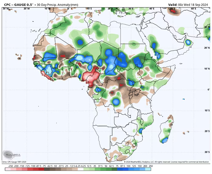
Precipitation differences from normal over Africa over the past 30 days. (WeatherBell)
Scientists aren’t sure exactly why the ITCZ has wobbled so far north this year. It could be because of the near-record warmth in the North Atlantic Ocean, increasing the temperature difference between the Northern and Southern hemispheres, according to Francesco S.R. Pausata, an atmospheric science professor at the University of Quebec in Montreal who has studied the ITCZ.
There could also be a connection to global warming heating the Northern Hemisphere more than the Southern Hemisphere. “The Northern Hemisphere, as there is more land than the Southern Hemisphere, tends to warm up more and hence it could push the ITCZ further north,” Pausata said in an email.
The northward shift in the ITCZ may also be contributing to the lack of Atlantic hurricane activity. Because tropical waves spawned by the ITCZ are exiting Africa into the Atlantic Ocean farther north than usual, they have been encountering cooler air and waters, which can limit the potential for development.
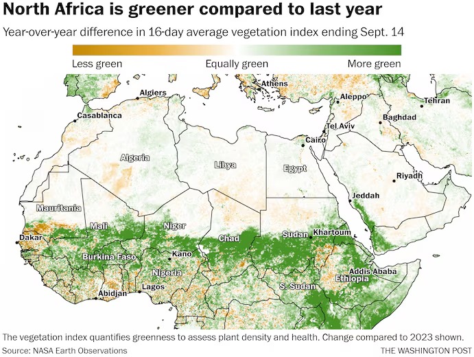
NASA satellites detect the density of vegetation such as leaves and grass. The image at the top of this article compares this year’s and last year’s density of vegetation, or greenness, for the 16-day period ending Sept. 14.
As heavy rain associated with the ITCZ has penetrated farther north than usual this year, the biggest increase in greenness over last year is shown across the strip of north-central Africa covering southern Mauritania, southern Mali, Burkina Faso, southern Niger, northern Nigeria, southern Chad, southern Sudan, and portions of South Sudan, Eritrea, Ethiopia and Kenya.
Share this article
No subscription required to read
Share
Just to the south, regions that have received significantly less rain than usual — including Guinea, Ghana, central to southern Nigeria, Cameroon, far southeast Sudan and a portion of western Ethiopia — have seen the biggest decrease in greenness from last year.
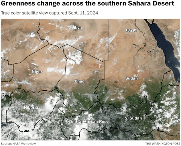
NASA satellites also capture what is called a “true color” view of the planet, which looks similar to what the human eye would see. In the animation below, greener areas indicate denser vegetation, while clouds show up as white.
(The Washington Post) GIF not working
The animation shows the true-color views from Sept. 11, 2024, and Sept. 9, 2023. The most dramatic increase in greenness this year can be seen in southern Chad, southern Sudan and Eritrea. Clouds tend to block the view of those areas to the south that are less green than last year.
The northward shift in greenness is the result of monsoon rains pushing farther north than usual. Portions of Mali, Niger, Chad, Sudan and Eritrea have seen the largest increases in rainfall compared with normal. Some areas have received as much rain in the past month as would typically fall in a half-year or more.
NASA documented a sudden change in the landscape after a storm unloaded heavy rain across the northwestern Sahara on Sept. 7 and 8, drenching parts of Morocco and Algeria, where such downpours are rare.
https://x.com/NASAEarth/status/1836071502384394313?
https://www.washingtonpost.com/weather/2024/09/19/sahara-desert-rain-africa-flooding/