Date: 10/01/2026 10:37:55
From: Ian
ID: 2348680
Subject: Victorian Fires +
.
About 0300
Smokin
.
About 0300
Smokin
Ian said:
Smokin
wait Sydney is part of the Victorian fires now damn
That top pic is horrifying. Amazing technique though, certainly makes for a dramatic photo.
SCIENCE said:
Ian said:
Smokin
wait Sydney is part of the Victorian fires now damn
Possibly. Where are we drawing the line?
Ian said:
SCIENCE said:Ian said:
Smokin
wait Sydney is part of the Victorian fires now damn
Possibly. Where are we drawing the line?
Here and here
Divine Angel said:
That top pic is horrifying. Amazing technique though, certainly makes for a dramatic photo.
Ya, beautiful and deadly.
I don’t think there’s much post there.
Michael V said:
Great.
Divine Angel said:
Ian said:
SCIENCE said:wait Sydney is part of the Victorian fires now damn
Possibly. Where are we drawing the line?
Here and here
But they’re pretty arbitrary.. except in the case of the Mighty Murray River.
Ian said:
Divine Angel said:
Ian said:Possibly. Where are we drawing the line?
Here and here
But they’re pretty arbitrary.. except in the case of the Mighty Murray River.
Yeah I don’t understand state/territory borders. The NSW/Qld border on maps is the river, but in reality, it’s north of the river.
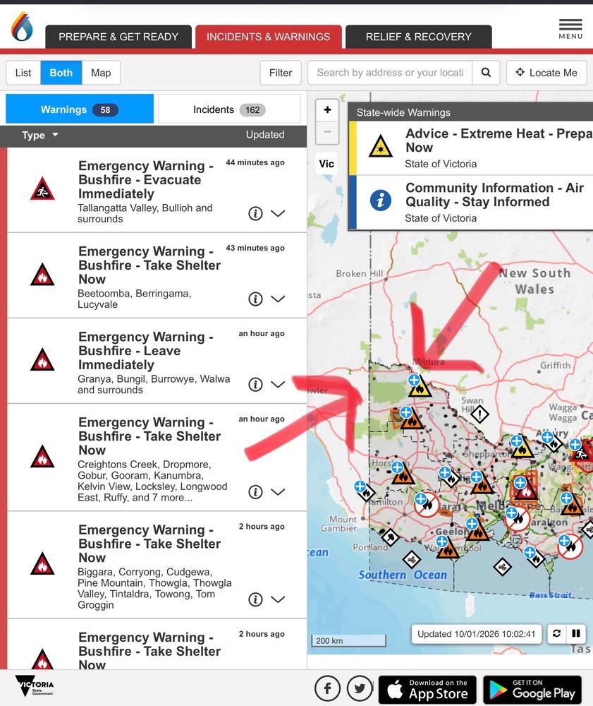
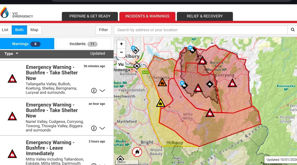
But anyway, my point of that pic was I’ve not seen or heard any warnings for SA, particularly Mt Gambier, which looks like it could be facing some issues based on the Vic emergency map. (Certainly not intended to make light of the current emergency in Victoria.)
Ian said:
Divine Angel said:
That top pic is horrifying. Amazing technique though, certainly makes for a dramatic photo.
Ya, beautiful and deadly.
I don’t think there’s much post there.
Terrific.
Peak Warming Man said:
Ian said:
Divine Angel said:
That top pic is horrifying. Amazing technique though, certainly makes for a dramatic photo.
Ya, beautiful and deadly.
I don’t think there’s much post there.
Terrific.
Terrific that all the farmers’ fences have been burnt out?
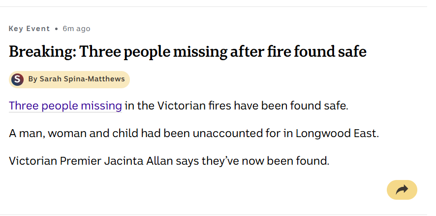
Glad the missing people have been found safe.
Michael V said:
Peak Warming Man said:
Ian said:Ya, beautiful and deadly.
I don’t think there’s much post there.
Terrific.
Terrific that all the farmers’ fences have been burnt out?
Tear down that wall!
Divine Angel said:
Ian said:
Divine Angel said:Here and here
But they’re pretty arbitrary.. except in the case of the Mighty Murray River.
Yeah I don’t understand state/territory borders. The NSW/Qld border on maps is the river, but in reality, it’s north of the river.
But anyway, my point of that pic was I’ve not seen or heard any warnings for SA, particularly Mt Gambier, which looks like it could be facing some issues based on the Vic emergency map. (Certainly not intended to make light of the current emergency in Victoria.)
Maybe that line works.
Ian said:
Divine Angel said:
Ian said:But they’re pretty arbitrary.. except in the case of the Mighty Murray River.
Yeah I don’t understand state/territory borders. The NSW/Qld border on maps is the river, but in reality, it’s north of the river.
But anyway, my point of that pic was I’ve not seen or heard any warnings for SA, particularly Mt Gambier, which looks like it could be facing some issues based on the Vic emergency map. (Certainly not intended to make light of the current emergency in Victoria.)
Maybe that line works.
Maybe algal blooms prevent bushfires.
Witty Rejoinder said:
Michael V said:
Peak Warming Man said:Terrific.
Terrific that all the farmers’ fences have been burnt out?
Tear down that wall!
Strachan?
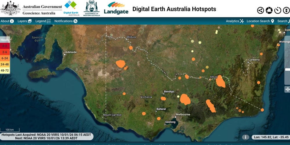
I can’t remember who put me onto this site. Maybe Rule, or Kingy. Anyway…a hotspots map.
buffy said:
I can’t remember who put me onto this site. Maybe Rule, or Kingy. Anyway…a hotspots map.
Good one
Ian said:
buffy said:
I can’t remember who put me onto this site. Maybe Rule, or Kingy. Anyway…a hotspots map.Good one
Ta.
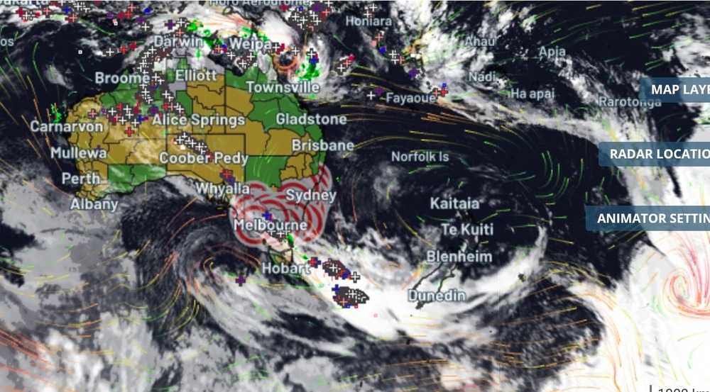
Meanwhile…
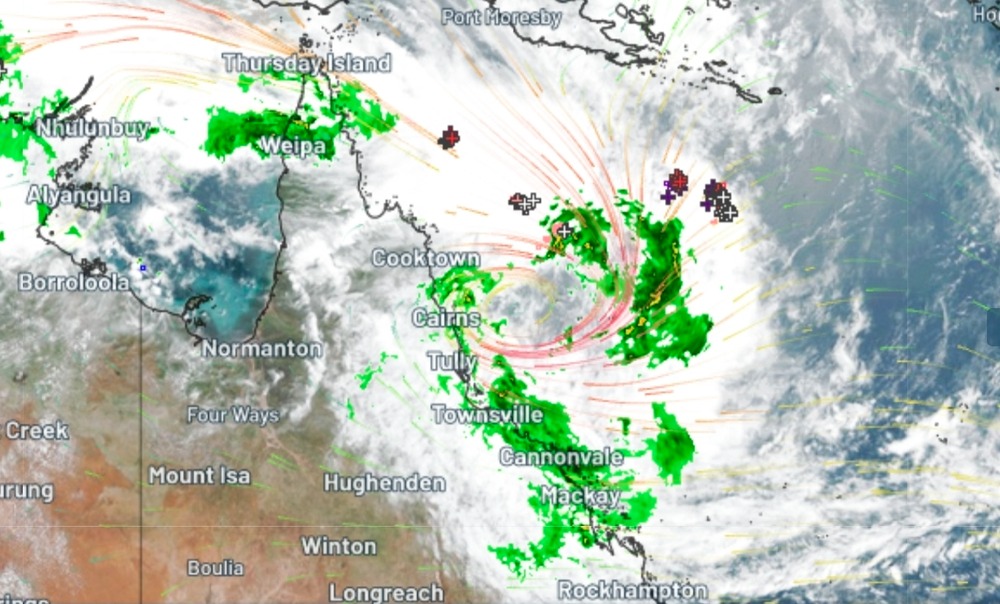
Only a Tropical Low or potential cyclone… whatever
Getting a bit of shape, rotation happening.
Ian said:
Meanwhile…
Only a Tropical Low or potential cyclone… whatever
Getting a bit of shape, rotation happening.
Coastal lows aren’t far off beiing a cyclone and can be just as devastating.
Anecdote only..
A few years ago, on a Sunday, travelling from Tallangatta along the Murray Valley Hwy, I spent a couple of hours in the very pretty town of Corryong, having pulled over the van (near the historic wooden tressle viaduct) bc radial tyre separation. I drove a little way on to Koetong pub (publican was a bit of a prick) and decided to head back to Tallangatta for a day to get the tyre replaced.
Missed the rendezvous with my brother in Jindabyne by 24 hours.
Ian said:
Anecdote only..
A few years ago, on a Sunday, travelling from Tallangatta along the Murray Valley Hwy, I spent a couple of hours in the very pretty town of Corryong, having pulled over the van (near the historic wooden tressle viaduct) bc radial tyre separation. I drove a little way on to Koetong pub (publican was a bit of a prick) and decided to head back to Tallangatta for a day to get the tyre replaced.
Missed the rendezvous with my brother in Jindabyne by 24 hours.
What did you do with your payload of narcotics?
Witty Rejoinder said:
Ian said:
Anecdote only..
A few years ago, on a Sunday, travelling from Tallangatta along the Murray Valley Hwy, I spent a couple of hours in the very pretty town of Corryong, having pulled over the van (near the historic wooden tressle viaduct) bc radial tyre separation. I drove a little way on to Koetong pub (publican was a bit of a prick) and decided to head back to Tallangatta for a day to get the tyre replaced.
Missed the rendezvous with my brother in Jindabyne by 24 hours.
What did you do with your payload of narcotics?
:)
I couldn’t even locate any weed.
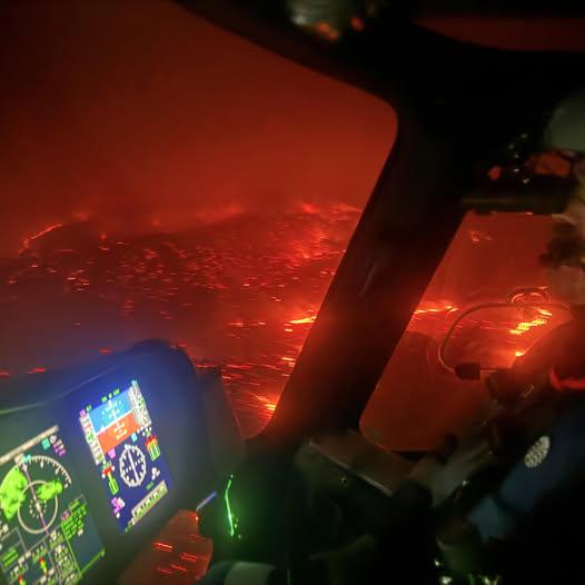
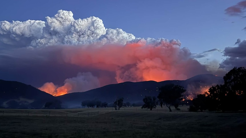
“Aerial view of the bushfire near Yea”
Spiny Norman said:
“Aerial view of the bushfire near Yea”
I just looked at FlightRadar24. The Otways has got a couple of Firebirds (helicopters) a Bird-dog (plane) and a Bomber working. Over in central Victoria there are various helitacs and bombers. One of the problems yesterday was apparently that the wind kept the planes on the ground.
Spiny Norman said:
“Aerial view of the bushfire near Yea”
It looks like one of those WW2 photos of German cities burning after air raids.
Some more photos here. It looks horrendous. :(
https://www.reddit.com/r/australian/comments/1q8rihr/north_east_vic_fires/
Footage from the 2020 Australian bushfires showing just how quickly the fires can spread.
Just noticed that Conair are using a Bombardier dash8 as a Large Air Tanker. I haven’t seen that before.

Kingy said:
Just noticed that Conair are using a Bombardier dash8 as a Large Air Tanker. I haven’t seen that before.
They must be able to dump the water pretty evenly, as if too much came out of one end the pane’s CoG would be out of limits. And that’s bad.
captain_spalding said:
Spiny Norman said:
“Aerial view of the bushfire near Yea”
It looks like one of those WW2 photos of German cities burning after air raids.
so if bombing fascists is a thing we should see some more soon
SCIENCE said:
captain_spalding said:
Spiny Norman said:
“Aerial view of the bushfire near Yea”
It looks like one of those WW2 photos of German cities burning after air raids.
so if bombing fascists is a thing we should see some more soon
Not at all amusing, one more than one level.
buffy said:
Spiny Norman said:
“Aerial view of the bushfire near Yea”
I just looked at FlightRadar24. The Otways has got a couple of Firebirds (helicopters) a Bird-dog (plane) and a Bomber working. Over in central Victoria there are various helitacs and bombers. One of the problems yesterday was apparently that the wind kept the planes on the ground.
How have waterbombing helicopters and aircraft improved from the days of Elvis and Georgia Peach et al?
Divine Angel said:
buffy said:
Spiny Norman said:
“Aerial view of the bushfire near Yea”
I just looked at FlightRadar24. The Otways has got a couple of Firebirds (helicopters) a Bird-dog (plane) and a Bomber working. Over in central Victoria there are various helitacs and bombers. One of the problems yesterday was apparently that the wind kept the planes on the ground.
How have waterbombing helicopters and aircraft improved from the days of Elvis and Georgia Peach et al?
Much the same I’d guess. Hopefully more of them though.
Divine Angel said:
buffy said:
Spiny Norman said:
“Aerial view of the bushfire near Yea”
I just looked at FlightRadar24. The Otways has got a couple of Firebirds (helicopters) a Bird-dog (plane) and a Bomber working. Over in central Victoria there are various helitacs and bombers. One of the problems yesterday was apparently that the wind kept the planes on the ground.
How have waterbombing helicopters and aircraft improved from the days of Elvis and Georgia Peach et al?
More of them, and faster. Ex Air Force Blackhawks are the current gear.
captain_spalding said:
SCIENCE said:
captain_spalding said:
It looks like one of those WW2 photos of German cities burning after air raids.
so if bombing fascists is a thing we should see some more soon
Not at all amusing, one more than one level.
agreed it’s as amusing as when we say “this is all going to be over soon” or any other synonym
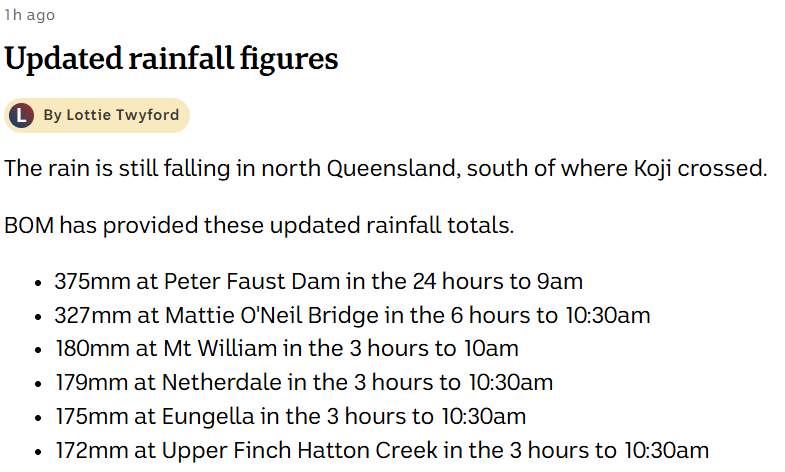
Cyclone Koji.. cat one system has hit land between the Burdekin River mouth and Cape Upstart, north-west of Bowen.
Heavy rainfall has started with 84mm recorded in the past hour at Netherdale, west of Mackay.
Angus Hines from the Bureau of Meteorology says the rain will continue throughout the afternoon.
“Our daily rainfall totals are going to be significant, 24-hour rainfall totals are now up to 380mm for the area so it’s a lot of rain and there’s a lot more still to come so absolutely buckle down and stay put”.
—
Why the name “Koji”?
Ian said:
Cyclone Koji.. cat one system has hit land between the Burdekin River mouth and Cape Upstart, north-west of Bowen.Heavy rainfall has started with 84mm recorded in the past hour at Netherdale, west of Mackay.
Angus Hines from the Bureau of Meteorology says the rain will continue throughout the afternoon.
“Our daily rainfall totals are going to be significant, 24-hour rainfall totals are now up to 380mm for the area so it’s a lot of rain and there’s a lot more still to come so absolutely buckle down and stay put”.
—
Why the name “Koji”?
All that water could easily put out vic fires.
Tau.Neutrino said:
Ian said:
Cyclone Koji.. cat one system has hit land between the Burdekin River mouth and Cape Upstart, north-west of Bowen.Heavy rainfall has started with 84mm recorded in the past hour at Netherdale, west of Mackay.
Angus Hines from the Bureau of Meteorology says the rain will continue throughout the afternoon.
“Our daily rainfall totals are going to be significant, 24-hour rainfall totals are now up to 380mm for the area so it’s a lot of rain and there’s a lot more still to come so absolutely buckle down and stay put”.
—
Why the name “Koji”?
All that water could easily put out vic fires.
Just need another super pipe and use it as a big hose.
Ian said:
Cyclone Koji.. cat one system has hit land between the Burdekin River mouth and Cape Upstart, north-west of Bowen.Heavy rainfall has started with 84mm recorded in the past hour at Netherdale, west of Mackay.
Angus Hines from the Bureau of Meteorology says the rain will continue throughout the afternoon.
“Our daily rainfall totals are going to be significant, 24-hour rainfall totals are now up to 380mm for the area so it’s a lot of rain and there’s a lot more still to come so absolutely buckle down and stay put”.
—
Why the name “Koji”?
I guess it was the name on their list.
Ian said:
Cyclone Koji.. cat one system has hit land between the Burdekin River mouth and Cape Upstart, north-west of Bowen.Heavy rainfall has started with 84mm recorded in the past hour at Netherdale, west of Mackay.
Angus Hines from the Bureau of Meteorology says the rain will continue throughout the afternoon.
“Our daily rainfall totals are going to be significant, 24-hour rainfall totals are now up to 380mm for the area so it’s a lot of rain and there’s a lot more still to come so absolutely buckle down and stay put”.
—
Why the name “Koji”?
https://www.bom.gov.au/resources/learn-and-explore/tropical-cyclone-knowledge-centre/naming-tropical-cyclones#bom-anchor-list__item-how-tropical-cyclones-are-named
We’re on the Section 2 list. There’s a few uncommon names in that list, but you’ll be glad to see there will be a TC Tim coming up.
Akio (ah-kee-oh)
Bianca (bee-ahng-kuh)
Courtney (kawrt-nee)
Dianne (dai-an)
Errol (er-uhl)
Fina (fee-nuh) – first name to be allocated in 2025–26
Grant (grant)
Hayley (hei-lee)
Iggy (ig-ee)
Jenna (jen-uh)
Koji (koh-jee)
Luana (loo-ah-nuh)
Mitchell (mich-uhl)
Narelle (nuh-rel)
Oran (aw-ran)
Peta (pee-tuh)
Riordan (rier-duhn)
Sandra (san-druh)
Tim (tim)
Victoria (vik-tawr-ee-uh)
Zane (zein)
party_pants said:
Ian said:
Cyclone Koji.. cat one system has hit land between the Burdekin River mouth and Cape Upstart, north-west of Bowen.Heavy rainfall has started with 84mm recorded in the past hour at Netherdale, west of Mackay.
Angus Hines from the Bureau of Meteorology says the rain will continue throughout the afternoon.
“Our daily rainfall totals are going to be significant, 24-hour rainfall totals are now up to 380mm for the area so it’s a lot of rain and there’s a lot more still to come so absolutely buckle down and stay put”.
—
Why the name “Koji”?
https://www.bom.gov.au/resources/learn-and-explore/tropical-cyclone-knowledge-centre/naming-tropical-cyclones#bom-anchor-list__item-how-tropical-cyclones-are-named
We’re on the Section 2 list. There’s a few uncommon names in that list, but you’ll be glad to see there will be a TC Tim coming up.
Excellent. Hope it’s a biggun.. will please grandson :)
I’m sure people near Koji would be happy to give this rain to Victoria.