Date: 24/03/2026 09:45:14
From: Divine Angel
ID: 2372789
Subject: Cyclone Narelle

For our WAlien forumers since Narelle’s looking likely to impact Perth in some capacity.

From: Tony Cornelius, meteorologist, on Facebook.

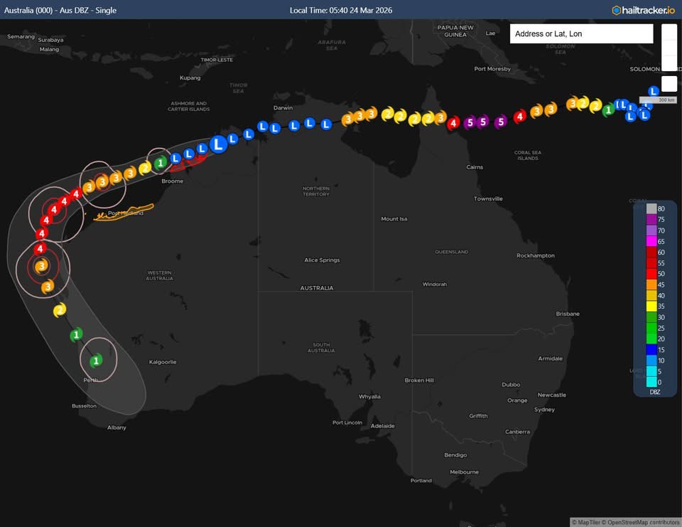
Tropical Cyclone Narelle May Pose Significant Threat to West Coast of Australia (Perth to Exmouth)

While still an ex-tropical cyclone, Narelle is forecast to push into the Indian Ocean overnight where it’s expected to intensify back into a tropical cyclone thanks to favourable wind shear and warm ocean temperatures. Narelle will continue to be steered by an upper high, meaning the further west it tracks, it will adopt a more WSW to SW movement.

During Friday and the weekend, Narelle will be sufficiently south to become steered by an approaching cold front which is likely to cause a sharp recurve back towards the southeast resulting in the west coast of Western Australia coming into the firing line.

Is it too far out to be concerned?

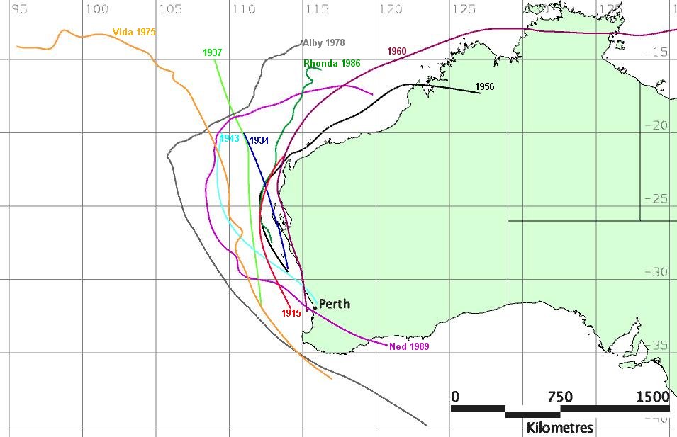
It’s only Tuesday and we’re looking at impacts 4-5 days away, but tropical cyclones in Western Australia operate a little differently to tropical cyclones in the Coral Sea. Unlike their Coral Sea counterparts, tropical cyclones in Western Australia once they recurve become far more predictable which provides a higher degree of confidence than say Alfred last year for southern Queensland and Brisbane.

While it’s not “locked in” – it does mean we have a concern for the west coast of Western Australia and the system is worth monitoring.

“It’s all about the recurve”

Probably the main uncertainty is about the recurve. If Narelle recurves earlier than forecast, it will plough into the Pilbara and track inland. Obviously, we’d rather a tropical cyclone not cross the coastline at all – but if it had to cross, it’s better to do so here. For one, there’s stricter building codes, but also the population density is lower too.

Meanwhile, if Narelle recurves later, then the southeast track may be too far offshore to significantly impact the West Australian coastline.

But currently, most models have Narelle recurving in the ‘Goldilocks’ zone – which is resulting in Narelle tracking down or very close to the west coast of Western Australia which is the concern.

Will Narelle still be a tropical cyclone that far south?

Narelle may not be a tropical cyclone by definition at this point – but this is potentially a worse scenario.

That’s because Narelle may potentially transition into an “extra-tropical” cyclone. This is the same mechanism that results in very intense systems surviving so far north along the USA east coast (think Hurricane Sandy). These systems transition from a warm-core (barotropic) to a cold-core (baroclinic) structure, meaning they begin to derive energy from the temperature contrast between warm tropical and cold polar air masses rather than solely from ocean heat. This allows them to maintain destructive (Cat 2/3) winds well after losing tropical characteristics.

So why is this more dangerous? Extra-tropical systems tend to have broader wind fields, meaning you don’t need to be very close to the eye to see cyclonic winds. Compare this to Alfred which had a small zone of cyclonic winds (thankfully!) But the radius of >90km/h winds could be quite large in Narelle as it tracks southwards. What’s more, the potential for destructive (>125km/h) and very destructive (>165km/h) winds may also shift away from the centre which is a concern.

What Intensity will Narelle be?

This is the other unknown. Essentially the stronger Narelle is in the tropical waters, the longer it will retain its intensity when it begins to shift to the southeast. So ideally, we don’t want Narelle to get as strong as currently forecast in the Indian Ocean.

Is this a definite impact?

As mentioned – no, we could see a shift in the recurve that reduces the risk. There’s even a small chance that if Narelle doesn’t get far enough south, it won’t come under the influence of the approaching trough. But the risk is worth noting and if you live anywhere from Perth to Exmouth, Narelle is well worth watching as we approach the weekend as the potential is for a pretty significant system.

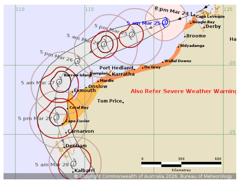
Attached BoM track courtesy of hailtracker.io

Reply Quote

Date: 24/03/2026 10:13:55
From: SCIENCE
ID: 2372805
Subject: re: Cyclone Narelle

what a journey

Reply Quote

Date: 24/03/2026 10:21:01
From: roughbarked
ID: 2372809
Subject: re: Cyclone Narelle

SCIENCE said:

what a journey

Epic journey.

Reply Quote

Date: 24/03/2026 10:25:39
From: Peak Warming Man
ID: 2372811
Subject: re: Cyclone Narelle

SCIENCE said:

what a journey

They’ll probably make a movie of it, The Life and Times of Narelle

Reply Quote

Date: 24/03/2026 10:48:51
From: Tamb
ID: 2372813
Subject: re: Cyclone Narelle

Peak Warming Man said:


SCIENCE said:

what a journey

They’ll probably make a movie of it, The Life and Times of Narelle


I live in FNQ & the locals were not at all fussed about Narelle. Way too far away to be concerned.

Reply Quote

Date: 24/03/2026 10:53:22
From: Peak Warming Man
ID: 2372815
Subject: re: Cyclone Narelle

Tamb said:


Peak Warming Man said:

SCIENCE said:

what a journey

They’ll probably make a movie of it, The Life and Times of Narelle


I live in FNQ & the locals were not at all fussed about Narelle. Way too far away to be concerned.

It was further north?

Reply Quote

Date: 25/03/2026 09:38:29
From: Michael V
ID: 2373121
Subject: re: Cyclone Narelle

Narelle has re-developed and is now Cat 1, expected to continue developing. Track map issued at 5:53 am WST on Wednesday 25 March 2026. The next Forecast Track Map will be issued by 9:00 am AWST Wednesday.

https://www.bom.gov.au/warning/tropical-cyclone-forecast-track-map/IDW60281

Reply Quote

Date: 25/03/2026 10:04:20
From: Peak Warming Man
ID: 2373123
Subject: re: Cyclone Narelle

Michael V said:


Narelle has re-developed and is now Cat 1, expected to continue developing. Track map issued at 5:53 am WST on Wednesday 25 March 2026. The next Forecast Track Map will be issued by 9:00 am AWST Wednesday.

https://www.bom.gov.au/warning/tropical-cyclone-forecast-track-map/IDW60281

It might give Perth a bit of a hurry up.

Reply Quote

Date: 25/03/2026 10:12:30
From: Bogsnorkler
ID: 2373124
Subject: re: Cyclone Narelle

Peak Warming Man said:


Michael V said:

Narelle has re-developed and is now Cat 1, expected to continue developing. Track map issued at 5:53 am WST on Wednesday 25 March 2026. The next Forecast Track Map will be issued by 9:00 am AWST Wednesday.

https://www.bom.gov.au/warning/tropical-cyclone-forecast-track-map/IDW60281

It might give Perth a bit of a hurry up.

Reply Quote

Date: 26/03/2026 15:58:40
From: Divine Angel
ID: 2373652
Subject: re: Cyclone Narelle

Also from Anthony Cornelius on Facebook.

Dangerous Conditions Ahead as Tropical Cyclone Narelle Forecast to Cross for a Third Time

Why the concern for Western Australia?

While not unheard of, it’s not common for such a strong system to survive so far south. Many older buildings were built before stricter building codes were introduced. For this reason, if you live along the WA coastline you NEED to be commencing your tropical cyclone preparations. This is particularly the case for those south of Carnarvon where tropical cyclones are typically much rarer! Narelle is likely to generate cyclonic conditions to numerous towns with towns and buildings more prevalent further south closer to Perth.

Could Narelle ‘Veer Off Course’?

Unfortunately this is very unlikely. A cold front and upper trough is approaching from the west which will change the steering influence of Narelle and is expected to cause it to track towards the S and SE. As the steering influences are strong and defined. The more likely case is that the recurve is different, if the recurve is earlier this may be a better scenario as Narelle will cross land sooner, and track further inland faster (keeping it away from the more populated west coast). If the recurve is later, this could become a more concerning scenario as it may remain over the ocean for longer and then potentially impact areas even further south than currently forecast.

Why is Narelle Surviving So Far South?

Firstly, as Narelle interacts with the approaching cold front the stronger wind shear will cause Narelle to move more quickly. This will allow Narelle to cover more ground, and potentially could move at 40-50km/h (or more) which is very fast for a tropical cyclone.

Secondly, Narelle will undergo “extra-tropical transition” – that is, it will begin to derive energy for the upper atmosphere which will decrease the rate of which Narelle weakens. This transition will also help Narelle survive a more ‘hostile’ environment.

When was the last time the region was impacted by a tropical cyclone?

Surprisingly, not that long ago. TC Seroja impacted Kalbarri in 2021 as a low category 3 system but was smaller and took a path that pushed inland more quickly (therefore weakening more quickly). The radius of winds in Narelle is likely to be much larger, and the trajectory is likely to impact more people meaning the impacts could be worse and more widespread.

Reply Quote

Date: 26/03/2026 21:48:41
From: Divine Angel
ID: 2373796
Subject: re: Cyclone Narelle

Oh no! Not the trolley!

Reply Quote

Date: 26/03/2026 21:52:05
From: party_pants
ID: 2373798
Subject: re: Cyclone Narelle

Divine Angel said:


Oh no! Not the trolley!


Saw that earlier. I’m sure they can afford to buy a few new ones up there when the storm is all over.

Reply Quote

Date: 26/03/2026 22:06:56
From: party_pants
ID: 2373799
Subject: re: Cyclone Narelle

We spent an hour or so at work this afternoon doing a bit of a cleanup and putting away of things in safe places. Tarping up and double-roping other things.

Just in case.

Reply Quote

Date: 26/03/2026 22:25:20
From: kii
ID: 2373803
Subject: re: Cyclone Narelle

Little bit of distant thunder about an hour ago. Son said some rain on their trip back from Perth.
Waiting…

Reply Quote

Date: 27/03/2026 02:41:53
From: kii
ID: 2373817
Subject: re: Cyclone Narelle

https://earth.nullschool.net/#current/wind/surface/level/orthographic=-244.75,-22.64,767

One of my favourite things.

Reply Quote

Date: 27/03/2026 11:28:58
From: Kingy
ID: 2373903
Subject: re: Cyclone Narelle

Exmouth/Learmonth wind gusts of 200kmh. Rain radar offline.

Reply Quote

Date: 27/03/2026 11:31:03
From: roughbarked
ID: 2373905
Subject: re: Cyclone Narelle

Kingy said:


Exmouth/Learmonth wind gusts of 200kmh. Rain radar offline.


You know it is windy when the wind recording devices are blown over.

Reply Quote

Date: 27/03/2026 11:33:10
From: Michael V
ID: 2373906
Subject: re: Cyclone Narelle

Kingy said:


Exmouth/Learmonth wind gusts of 200kmh. Rain radar offline.


Narelle, Cyclops-like, has a huge eye.

Reply Quote

Date: 27/03/2026 11:38:42
From: Divine Angel
ID: 2373908
Subject: re: Cyclone Narelle

Kingy said:


Exmouth/Learmonth wind gusts of 200kmh. Rain radar offline.


That is an impressive photo.

Reply Quote

Date: 27/03/2026 11:40:26
From: Peak Warming Man
ID: 2373911
Subject: re: Cyclone Narelle

Kingy said:


Exmouth/Learmonth wind gusts of 200kmh. Rain radar offline.


You’re welcome.

Reply Quote

Date: 27/03/2026 11:41:53
From: Kingy
ID: 2373913
Subject: re: Cyclone Narelle

Michael V said:


Kingy said:

Exmouth/Learmonth wind gusts of 200kmh. Rain radar offline.


Narelle, Cyclops-like, has a huge eye.

The little village of Coral Bay is next. It’s mostly a giant caravan park. It’ll get a direct hit from a cat 4.

Reply Quote

Date: 27/03/2026 11:43:45
From: roughbarked
ID: 2373916
Subject: re: Cyclone Narelle

Kingy said:


Michael V said:

Kingy said:

Exmouth/Learmonth wind gusts of 200kmh. Rain radar offline.


Narelle, Cyclops-like, has a huge eye.

The little village of Coral Bay is next. It’s mostly a giant caravan park. It’ll get a direct hit from a cat 4.

Caravans aren’t really made to withstand cyclonic winds. In my mind I can see shattered caravans everywhere across the landscape.
Tell me I’m wrong.

Reply Quote

Date: 27/03/2026 11:47:34
From: Michael V
ID: 2373918
Subject: re: Cyclone Narelle

Kingy said:


Michael V said:

Kingy said:

Exmouth/Learmonth wind gusts of 200kmh. Rain radar offline.


Narelle, Cyclops-like, has a huge eye.

The little village of Coral Bay is next. It’s mostly a giant caravan park. It’ll get a direct hit from a cat 4.

Ouch. Cat 4 on caravans it not going to be a good look.

Reply Quote

Date: 27/03/2026 11:50:22
From: Divine Angel
ID: 2373920
Subject: re: Cyclone Narelle

Kingy said:


Michael V said:

Kingy said:

Exmouth/Learmonth wind gusts of 200kmh. Rain radar offline.


Narelle, Cyclops-like, has a huge eye.

The little village of Coral Bay is next. It’s mostly a giant caravan park. It’ll get a direct hit from a cat 4.


Hopefully they’ve listened to warnings and evacuated early.

Reply Quote

Date: 27/03/2026 12:24:16
From: kii
ID: 2373933
Subject: re: Cyclone Narelle

roughbarked said:

Caravans aren’t really made to withstand cyclonic winds. In my mind I can see shattered caravans everywhere across the landscape.
Tell me I’m wrong.

Reply Quote

Date: 27/03/2026 16:23:19
From: buffy
ID: 2374007
Subject: re: Cyclone Narelle

Been listening to the news in the car while we have been out. I keep hearing them talking about Ex-mouth. I’m sure when my father was working on the cathodic protection on the long wharves over on the West coast in the 1960s, people called that place Ex-mth. Maybe my memory is faulty.

Reply Quote

Date: 27/03/2026 16:37:26
From: party_pants
ID: 2374010
Subject: re: Cyclone Narelle

buffy said:


Been listening to the news in the car while we have been out. I keep hearing them talking about Ex-mouth. I’m sure when my father was working on the cathodic protection on the long wharves over on the West coast in the 1960s, people called that place Ex-mth. Maybe my memory is faulty.

Ex-mouth is the standard pronunciation over here. Even though a similar named place in the UK would always be pronounced with a -mth ending. We generally don’t follow UK patterns but pronounce them as per the spelling. Similarly places ending with -ham are pronounced as such with the hard H sound, and Derby is with an e sound and not an a.

Reply Quote

Date: 27/03/2026 16:52:20
From: kii
ID: 2374013
Subject: re: Cyclone Narelle

Nice light rain here 🌧
Utter bliss.

Reply Quote

Date: 27/03/2026 16:59:53
From: buffy
ID: 2374014
Subject: re: Cyclone Narelle

party_pants said:


buffy said:

Been listening to the news in the car while we have been out. I keep hearing them talking about Ex-mouth. I’m sure when my father was working on the cathodic protection on the long wharves over on the West coast in the 1960s, people called that place Ex-mth. Maybe my memory is faulty.

Ex-mouth is the standard pronunciation over here. Even though a similar named place in the UK would always be pronounced with a -mth ending. We generally don’t follow UK patterns but pronounce them as per the spelling. Similarly places ending with -ham are pronounced as such with the hard H sound, and Derby is with an e sound and not an a.

One of the wharves was at Derby, so I’ve known about that one for the same length of time.

Reply Quote

Date: 27/03/2026 19:33:46
From: SCIENCE
ID: 2374047
Subject: re: Cyclone Narelle

damn Iranian proxies

Reply Quote

Date: 27/03/2026 19:45:27
From: party_pants
ID: 2374049
Subject: re: Cyclone Narelle

Been raining nearly all day here, since about 8:30am. Just steady light rain, 40+ mm so far.

The wind is expected to pick up tomorrow as the cyclone gets closer. I feel for the people out in the northern wheatbelt and Gascoyne who are going to cop a battering as the cyclone passes by them at still a Cat 1 or 2 strength. Not sure if many of the buildings up there are cyclone rated.

It may be we need to revise building codes for the region in response. They got a “once in a century” cyclone in 2021 that did a lot of damage up there. Just got everything rebuilt and fixed and now here’s another one only 5 years later.

Is it too early to say this is the impact of climate change? Cyclones coming further south than what we are used to.

Reply Quote

Date: 27/03/2026 19:49:53
From: kii
ID: 2374050
Subject: re: Cyclone Narelle

party_pants said:


Been raining nearly all day here, since about 8:30am. Just steady light rain, 40+ mm so far.

The wind is expected to pick up tomorrow as the cyclone gets closer. I feel for the people out in the northern wheatbelt and Gascoyne who are going to cop a battering as the cyclone passes by them at still a Cat 1 or 2 strength. Not sure if many of the buildings up there are cyclone rated.

It may be we need to revise building codes for the region in response. They got a “once in a century” cyclone in 2021 that did a lot of damage up there. Just got everything rebuilt and fixed and now here’s another one only 5 years later.

Is it too early to say this is the impact of climate change? Cyclones coming further south than what we are used to.

I remember a damaging storm that hit Bunbury a few years back. Cyclonic winds, iirc.

Reply Quote

Date: 27/03/2026 19:52:18
From: party_pants
ID: 2374051
Subject: re: Cyclone Narelle

kii said:


party_pants said:

Been raining nearly all day here, since about 8:30am. Just steady light rain, 40+ mm so far.

The wind is expected to pick up tomorrow as the cyclone gets closer. I feel for the people out in the northern wheatbelt and Gascoyne who are going to cop a battering as the cyclone passes by them at still a Cat 1 or 2 strength. Not sure if many of the buildings up there are cyclone rated.

It may be we need to revise building codes for the region in response. They got a “once in a century” cyclone in 2021 that did a lot of damage up there. Just got everything rebuilt and fixed and now here’s another one only 5 years later.

Is it too early to say this is the impact of climate change? Cyclones coming further south than what we are used to.

I remember a damaging storm that hit Bunbury a few years back. Cyclonic winds, iirc.

Big winter storms can bring high wind with gusts over 100 km/h. But they don’t get classified the same way.

Reply Quote

Date: 27/03/2026 19:54:22
From: JudgeMental
ID: 2374052
Subject: re: Cyclone Narelle

party_pants said:


Been raining nearly all day here, since about 8:30am. Just steady light rain, 40+ mm so far.

The wind is expected to pick up tomorrow as the cyclone gets closer. I feel for the people out in the northern wheatbelt and Gascoyne who are going to cop a battering as the cyclone passes by them at still a Cat 1 or 2 strength. Not sure if many of the buildings up there are cyclone rated.

It may be we need to revise building codes for the region in response. They got a “once in a century” cyclone in 2021 that did a lot of damage up there. Just got everything rebuilt and fixed and now here’s another one only 5 years later.

Is it too early to say this is the impact of climate change? Cyclones coming further south than what we are used to.

Light drizzle here for most of the day.

Reply Quote

Date: 27/03/2026 19:56:32
From: kii
ID: 2374053
Subject: re: Cyclone Narelle

party_pants said:


kii said:

party_pants said:

Been raining nearly all day here, since about 8:30am. Just steady light rain, 40+ mm so far.

The wind is expected to pick up tomorrow as the cyclone gets closer. I feel for the people out in the northern wheatbelt and Gascoyne who are going to cop a battering as the cyclone passes by them at still a Cat 1 or 2 strength. Not sure if many of the buildings up there are cyclone rated.

It may be we need to revise building codes for the region in response. They got a “once in a century” cyclone in 2021 that did a lot of damage up there. Just got everything rebuilt and fixed and now here’s another one only 5 years later.

Is it too early to say this is the impact of climate change? Cyclones coming further south than what we are used to.

I remember a damaging storm that hit Bunbury a few years back. Cyclonic winds, iirc.

Big winter storms can bring high wind with gusts over 100 km/h. But they don’t get classified the same way.

From 2024 Bunbury Tornado Support – South West Development Commission link.

Reply Quote

Date: 27/03/2026 19:57:55
From: Michael V
ID: 2374055
Subject: re: Cyclone Narelle

party_pants said:


Been raining nearly all day here, since about 8:30am. Just steady light rain, 40+ mm so far.

The wind is expected to pick up tomorrow as the cyclone gets closer. I feel for the people out in the northern wheatbelt and Gascoyne who are going to cop a battering as the cyclone passes by them at still a Cat 1 or 2 strength. Not sure if many of the buildings up there are cyclone rated.

It may be we need to revise building codes for the region in response. They got a “once in a century” cyclone in 2021 that did a lot of damage up there. Just got everything rebuilt and fixed and now here’s another one only 5 years later.

Is it too early to say this is the impact of climate change? Cyclones coming further south than what we are used to.

No, it probably is.

Reply Quote

Date: 27/03/2026 20:02:21
From: Michael V
ID: 2374056
Subject: re: Cyclone Narelle

Michael V said:


party_pants said:

Been raining nearly all day here, since about 8:30am. Just steady light rain, 40+ mm so far.

The wind is expected to pick up tomorrow as the cyclone gets closer. I feel for the people out in the northern wheatbelt and Gascoyne who are going to cop a battering as the cyclone passes by them at still a Cat 1 or 2 strength. Not sure if many of the buildings up there are cyclone rated.

It may be we need to revise building codes for the region in response. They got a “once in a century” cyclone in 2021 that did a lot of damage up there. Just got everything rebuilt and fixed and now here’s another one only 5 years later.

Is it too early to say this is the impact of climate change? Cyclones coming further south than what we are used to.

No, it probably is.

Too terse Michael. Easy to misinterpret.

No, it is not too early to say that. It likely is the result of climate change.

Although IIRC, one cyclone many years back emerged in the Bight still as a Cat 1, after crossing most of WA. It was a Cat 5 when it crossed the northern coast.

Reply Quote

Date: 27/03/2026 20:04:29
From: Divine Angel
ID: 2374057
Subject: re: Cyclone Narelle

Michael V said:


party_pants said:

Been raining nearly all day here, since about 8:30am. Just steady light rain, 40+ mm so far.

The wind is expected to pick up tomorrow as the cyclone gets closer. I feel for the people out in the northern wheatbelt and Gascoyne who are going to cop a battering as the cyclone passes by them at still a Cat 1 or 2 strength. Not sure if many of the buildings up there are cyclone rated.

It may be we need to revise building codes for the region in response. They got a “once in a century” cyclone in 2021 that did a lot of damage up there. Just got everything rebuilt and fixed and now here’s another one only 5 years later.

Is it too early to say this is the impact of climate change? Cyclones coming further south than what we are used to.

No, it probably is.

This morning I read something which said if this was the east coast, Coffs Harbour would be getting battered.

Reply Quote

Date: 27/03/2026 20:05:38
From: party_pants
ID: 2374058
Subject: re: Cyclone Narelle

Michael V said:


Michael V said:

party_pants said:

Been raining nearly all day here, since about 8:30am. Just steady light rain, 40+ mm so far.

The wind is expected to pick up tomorrow as the cyclone gets closer. I feel for the people out in the northern wheatbelt and Gascoyne who are going to cop a battering as the cyclone passes by them at still a Cat 1 or 2 strength. Not sure if many of the buildings up there are cyclone rated.

It may be we need to revise building codes for the region in response. They got a “once in a century” cyclone in 2021 that did a lot of damage up there. Just got everything rebuilt and fixed and now here’s another one only 5 years later.

Is it too early to say this is the impact of climate change? Cyclones coming further south than what we are used to.

No, it probably is.

Too terse Michael. Easy to misinterpret.

No, it is not too early to say that. It likely is the result of climate change.

Although IIRC, one cyclone many years back emerged in the Bight still as a Cat 1, after crossing most of WA. It was a Cat 5 when it crossed the northern coast.

Might have been Alby in 1978 or 1979-ish? I was in primary school at the time. I recall the school deciding to shut at lunchtime and we were all sent home.

Reply Quote

Date: 27/03/2026 20:08:23
From: Michael V
ID: 2374059
Subject: re: Cyclone Narelle

Michael V said:


Michael V said:

party_pants said:

Been raining nearly all day here, since about 8:30am. Just steady light rain, 40+ mm so far.

The wind is expected to pick up tomorrow as the cyclone gets closer. I feel for the people out in the northern wheatbelt and Gascoyne who are going to cop a battering as the cyclone passes by them at still a Cat 1 or 2 strength. Not sure if many of the buildings up there are cyclone rated.

It may be we need to revise building codes for the region in response. They got a “once in a century” cyclone in 2021 that did a lot of damage up there. Just got everything rebuilt and fixed and now here’s another one only 5 years later.

Is it too early to say this is the impact of climate change? Cyclones coming further south than what we are used to.

No, it probably is.

Too terse Michael. Easy to misinterpret.

No, it is not too early to say that. It likely is the result of climate change.

Although IIRC, one cyclone many years back emerged in the Bight still as a Cat 1, after crossing most of WA. It was a Cat 5 when it crossed the northern coast.

Vance (1999)

https://www.bom.gov.au/cyclone/history/vance.shtml

Reply Quote

Date: 27/03/2026 20:08:52
From: buffy
ID: 2374060
Subject: re: Cyclone Narelle

party_pants said:


Michael V said:

Michael V said:

No, it probably is.

Too terse Michael. Easy to misinterpret.

No, it is not too early to say that. It likely is the result of climate change.

Although IIRC, one cyclone many years back emerged in the Bight still as a Cat 1, after crossing most of WA. It was a Cat 5 when it crossed the northern coast.

Might have been Alby in 1978 or 1979-ish? I was in primary school at the time. I recall the school deciding to shut at lunchtime and we were all sent home.

Alby

Reply Quote

Date: 27/03/2026 20:14:11
From: party_pants
ID: 2374062
Subject: re: Cyclone Narelle

Reply Quote

Date: 27/03/2026 20:24:34
From: Divine Angel
ID: 2374064
Subject: re: Cyclone Narelle

party_pants said:


Love how the 1943 Cyclone got to Perth and said, “nah screw it” and just died out.

Reply Quote

Date: 27/03/2026 20:32:31
From: furious
ID: 2374065
Subject: re: Cyclone Narelle

Divine Angel said:


party_pants said:


Love how the 1943 Cyclone got to Perth and said, “nah screw it” and just died out.

The 1956 one is weird, started over land?

Reply Quote

Date: 27/03/2026 21:02:19
From: Ian
ID: 2374067
Subject: re: Cyclone Narelle

I was staying in Perth in 2015 when the remains of Severe Tropical Cyclone Olwyn rolled in. Track looks pretty similar to Narelle.

The weather changed from hot, hot, hot to warm wih showers.

Reply Quote

Date: 27/03/2026 21:13:01
From: furious
ID: 2374068
Subject: re: Cyclone Narelle

Ian said:


I was staying in Perth in 2015 when the remains of Severe Tropical Cyclone Olwyn rolled in. Track looks pretty similar to Narelle.

The weather changed from hot, hot, hot to warm wih showers.

Not sure what it was, but there was one, maybe 18 years ago, where the remains of a cyclone crossed paths with an Antarctic weather system heading north. Collided over the south coast. I was on the south coast at that time and it was quite the spectacle…

Reply Quote

Date: 27/03/2026 23:36:40
From: Kingy
ID: 2374092
Subject: re: Cyclone Narelle

party_pants said:


Michael V said:

Michael V said:

No, it probably is.

Too terse Michael. Easy to misinterpret.

No, it is not too early to say that. It likely is the result of climate change.

Although IIRC, one cyclone many years back emerged in the Bight still as a Cat 1, after crossing most of WA. It was a Cat 5 when it crossed the northern coast.

Might have been Alby in 1978 or 1979-ish? I was in primary school at the time. I recall the school deciding to shut at lunchtime and we were all sent home.

I was on my way home from school when Alby decided to be difficult.

The sky was red, we got into the bus, and drove though/into two bushfires, took a long detour around them and I got dropped off at the end of our half mile long driveway.

As I tried to walk home, I was getting sandblasted in the back of my neck and found a piece of cardboard pinned up against the fence. I used it to stop getting sandblasted by holding it up behind me, but ended up being blasted down the driveway like a kids toy with a sail on it.

Interesting day.

Reply Quote

Date: 28/03/2026 16:52:28
From: Spiny Norman
ID: 2374233
Subject: re: Cyclone Narelle

“This will go down as one of the most remarkable satellite loops in the history of Australian cyclones.

Over the course of 12 days and ~3,500 miles, Cyclone Narelle made landfall on OPPOSITE sides of Australia at Category 3+ intensity as she tried to circumnavigate the continent.”

https://x.com/BackpirchCrew/status/2037697839661277640

Reply Quote