Date: 20/02/2014 17:09:59
From: Obviousman
ID: 492315
Subject: Ethel the Aardvark goes Quantity Surveying
We’ve probably all seen surveyors somewhere.
What are they actually measuring? The (theodolite?) they are looking through, the graduated pole they look at… how do they determine where to put what? What do they measure?
Date: 20/02/2014 17:15:39
From: PermeateFree
ID: 492317
Subject: re: Ethel the Aardvark goes Quantity Surveying
Obviousman said:
We’ve probably all seen surveyors somewhere.
What are they actually measuring? The (theodolite?) they are looking through, the graduated pole they look at… how do they determine where to put what? What do they measure?
From my experience, initially the surveyors were looking for the original pegs that were placed there when the land was first pegged out. They usually end up with a spade in their hand digging holes where they should be and surprisingly to me, usually find them.
Date: 20/02/2014 17:16:07
From: diddly-squat
ID: 492318
Subject: re: Ethel the Aardvark goes Quantity Surveying
Obviousman said:
We’ve probably all seen surveyors somewhere.
What are they actually measuring? The (theodolite?) they are looking through, the graduated pole they look at… how do they determine where to put what? What do they measure?
surveyors measure four things
- the distance between two points (theodolite)
- the bearing from one point to another, and (theodolite)
- the elevation difference between two points (surveyor’s pole)
- absolute position (GPS)
Date: 20/02/2014 17:17:52
From: The Rev Dodgson
ID: 492319
Subject: re: Ethel the Aardvark goes Quantity Surveying
Obviousman said:
We’ve probably all seen surveyors somewhere.
What are they actually measuring? The (theodolite?) they are looking through, the graduated pole they look at… how do they determine where to put what? What do they measure?
Back when I did a bit of surveying there were two instruments you might use: a level, for looking along a horizontal line and measuring levels (with the hrlp of the graduated pole), and a theodolite, for measuring angles. If you wanted to measure distances you had to measure a base line with a tape, then work everything out from angles.
These days you can get something called a total station which will measure distance as well as angles, and work everything out for you as well.
Surveying just ain’t what it used to be.
As to where to put the graduated pole (aka the levelling staff), you put it on top of the thing you want to know the level of.
Date: 20/02/2014 17:20:25
From: diddly-squat
ID: 492320
Subject: re: Ethel the Aardvark goes Quantity Surveying
diddly-squat said:
Obviousman said:
We’ve probably all seen surveyors somewhere.
What are they actually measuring? The (theodolite?) they are looking through, the graduated pole they look at… how do they determine where to put what? What do they measure?
surveyors measure four things
- the distance between two points (theodolite)
- the bearing from one point to another, and (theodolite)
- the elevation difference between two points (surveyor’s pole)
- absolute position (GPS)
well that didn’t work quite as intended…
distance, bearing, elevation difference and absolute position
Date: 20/02/2014 17:20:48
From: The Rev Dodgson
ID: 492321
Subject: re: Ethel the Aardvark goes Quantity Surveying
diddly-squat said:
Obviousman said:
We’ve probably all seen surveyors somewhere.
What are they actually measuring? The (theodolite?) they are looking through, the graduated pole they look at… how do they determine where to put what? What do they measure?
surveyors measure four things
- the distance between two points (theodolite)
- the bearing from one point to another, and (theodolite)
- the elevation difference between two points (surveyor’s pole)
- absolute position (GPS)
You can’t measure distance with a theodolite?
And when I were a lad we didn’t have none of those GPS thingys either.
Date: 20/02/2014 17:21:30
From: poikilotherm
ID: 492322
Subject: re: Ethel the Aardvark goes Quantity Surveying
The Rev Dodgson said:
diddly-squat said:
Obviousman said:
We’ve probably all seen surveyors somewhere.
What are they actually measuring? The (theodolite?) they are looking through, the graduated pole they look at… how do they determine where to put what? What do they measure?
surveyors measure four things
- the distance between two points (theodolite)
- the bearing from one point to another, and (theodolite)
- the elevation difference between two points (surveyor’s pole)
- absolute position (GPS)
And when I were a lad we didn’t have none of those GPS thingys either.
How inefficient.
Date: 20/02/2014 17:21:34
From: diddly-squat
ID: 492323
Subject: re: Ethel the Aardvark goes Quantity Surveying
The Rev Dodgson said:
Obviousman said:
We’ve probably all seen surveyors somewhere.
What are they actually measuring? The (theodolite?) they are looking through, the graduated pole they look at… how do they determine where to put what? What do they measure?
Back when I did a bit of surveying there were two instruments you might use: a level, for looking along a horizontal line and measuring levels (with the hrlp of the graduated pole), and a theodolite, for measuring angles. If you wanted to measure distances you had to measure a base line with a tape, then work everything out from angles.
These days you can get something called a total station which will measure distance as well as angles, and work everything out for you as well.
Surveying just ain’t what it used to be.
As to where to put the graduated pole (aka the levelling staff), you put it on top of the thing you want to know the level of.
close that traverse Rev…
Date: 20/02/2014 17:21:39
From: The Rev Dodgson
ID: 492324
Subject: re: Ethel the Aardvark goes Quantity Surveying
For “?” read “![]()
Date: 20/02/2014 17:21:40
From: The Rev Dodgson
ID: 492325
Subject: re: Ethel the Aardvark goes Quantity Surveying
For “?” read “![]()
Date: 20/02/2014 17:22:35
From: The Rev Dodgson
ID: 492326
Subject: re: Ethel the Aardvark goes Quantity Surveying
The Rev Dodgson said:
For “?” read “![]()
Never mind.
Date: 20/02/2014 17:23:14
From: diddly-squat
ID: 492327
Subject: re: Ethel the Aardvark goes Quantity Surveying
The Rev Dodgson said:
diddly-squat said:
Obviousman said:
We’ve probably all seen surveyors somewhere.
What are they actually measuring? The (theodolite?) they are looking through, the graduated pole they look at… how do they determine where to put what? What do they measure?
surveyors measure four things
- the distance between two points (theodolite)
- the bearing from one point to another, and (theodolite)
- the elevation difference between two points (surveyor’s pole)
- absolute position (GPS)
You can’t measure distance with a theodolite?
And when I were a lad we didn’t have none of those GPS thingys either.
sorry, distance is measured with a total station (laser source and prism reflector)
Date: 20/02/2014 17:23:47
From: Peak Warming Man
ID: 492328
Subject: re: Ethel the Aardvark goes Quantity Surveying
Proper surveying distances are measured in chains.
Date: 20/02/2014 17:24:39
From: The Rev Dodgson
ID: 492329
Subject: re: Ethel the Aardvark goes Quantity Surveying
Peak Warming Man said:
Proper surveying distances are measured in chains.
And furlongs.
Date: 20/02/2014 17:24:51
From: Peak Warming Man
ID: 492330
Subject: re: Ethel the Aardvark goes Quantity Surveying
And that’s why, even today, the surveyors assistant is known as the chainman.
Date: 20/02/2014 17:25:50
From: The Rev Dodgson
ID: 492331
Subject: re: Ethel the Aardvark goes Quantity Surveying
Peak Warming Man said:
And that’s why, even today, the surveyors assistant is known as the chainman.
Or the chainy, for the PC amongst us.
Date: 20/02/2014 17:25:56
From: diddly-squat
ID: 492332
Subject: re: Ethel the Aardvark goes Quantity Surveying
having said all that, virtually all standard cadastral and building surveying is still performed using closed traverses from a known survey point
Date: 20/02/2014 17:27:30
From: The Rev Dodgson
ID: 492333
Subject: re: Ethel the Aardvark goes Quantity Surveying
diddly-squat said:
having said all that, virtually all standard cadastral and building surveying is still performed using closed traverses from a known survey point
Yup, you can’t beat the old ways where you need a bit of precision.
- sucks on imaginary pipe-
Date: 20/02/2014 17:28:23
From: diddly-squat
ID: 492335
Subject: re: Ethel the Aardvark goes Quantity Surveying
an interesting point is that all UG surveying is inverted, all measurements are taken from the roof, down… not the floor, up.
Date: 20/02/2014 17:29:53
From: The Rev Dodgson
ID: 492336
Subject: re: Ethel the Aardvark goes Quantity Surveying
diddly-squat said:
an interesting point is that all UG surveying is inverted, all measurements are taken from the roof, down… not the floor, up.
Or from a N. Hemisphere perspective, the underground work is the right way up, and the surface work is upside down.
Date: 20/02/2014 17:30:24
From: sibeen
ID: 492337
Subject: re: Ethel the Aardvark goes Quantity Surveying
So to sum it all up, ERB, no-one here really knows the answer to your question.
Date: 20/02/2014 17:30:42
From: PM 2Ring
ID: 492338
Subject: re: Ethel the Aardvark goes Quantity Surveying
FWIW, quantity surveying is not the same thing as (land) surveying.
Quantity surveyor
A quantity surveyor (QS) is a professional working within the construction industry concerned with construction costs and contracts.
The services provided by the quantity surveyor include:
• Cost planning and commercial management during the entire life cycle of the project from inception to completion
• Value engineering
• Risk Management
• Procurement advice and assistance during the tendering procedures
• Commercial Management and Contract Administration
• Assistance in dispute resolution
• Asset Capitalisation
• Interim payment assessment
• Cost Management process
• Claim the extra cost of the design variation
Surveying
Surveying or land surveying is the technique, profession, and science of accurately determining the terrestrial or three-dimensional position of points and the distances and angles between them, commonly practiced by licensed surveyors, and members of various building professions.
Date: 20/02/2014 17:32:54
From: Obviousman
ID: 492339
Subject: re: Ethel the Aardvark goes Quantity Surveying
sibeen said:
So to sum it all up, ERB, no-one here really knows the answer to your question.
Yep! LOL
So how do they determine where they are measuring from and measuring to?
Date: 20/02/2014 17:35:10
From: Peak Warming Man
ID: 492341
Subject: re: Ethel the Aardvark goes Quantity Surveying
Some sites have GPS survey benchmarks now and just about all sites have their own project grid.
Date: 20/02/2014 17:36:55
From: The Rev Dodgson
ID: 492342
Subject: re: Ethel the Aardvark goes Quantity Surveying
For some historical context on this thread:
http://www.youtube.com/watch?v=eCM2nEBE0RY
Date: 20/02/2014 17:37:29
From: Peak Warming Man
ID: 492343
Subject: re: Ethel the Aardvark goes Quantity Surveying
And quantity surveying has little to do with theodolites and chains and angles, it measures the amount of wood or bricks in a house eg.
Date: 20/02/2014 17:38:43
From: diddly-squat
ID: 492344
Subject: re: Ethel the Aardvark goes Quantity Surveying
Obviousman said:
sibeen said:
So to sum it all up, ERB, no-one here really knows the answer to your question.
Yep! LOL
So how do they determine where they are measuring from and measuring to?
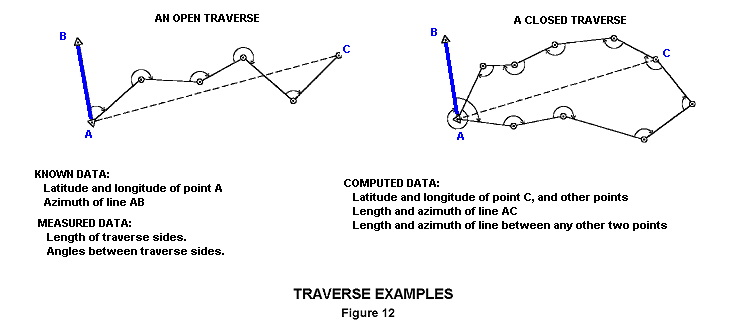
there are a series of known or ‘fixed’ points. The position of these points is well defined in all three dimensions.
A surveyor then shoots from the known point to the point (or points) of interest so as to locate it (or them) on the ground.
The surveyor then shoot back from the point of interest to the know point so as to ‘close’ what’s call a ‘traverse’
This way the surveyor can either locate points on the ground from a plan, or survey a point on the ground so as to locate it on a plan.
Date: 20/02/2014 17:39:15
From: PermeateFree
ID: 492345
Subject: re: Ethel the Aardvark goes Quantity Surveying
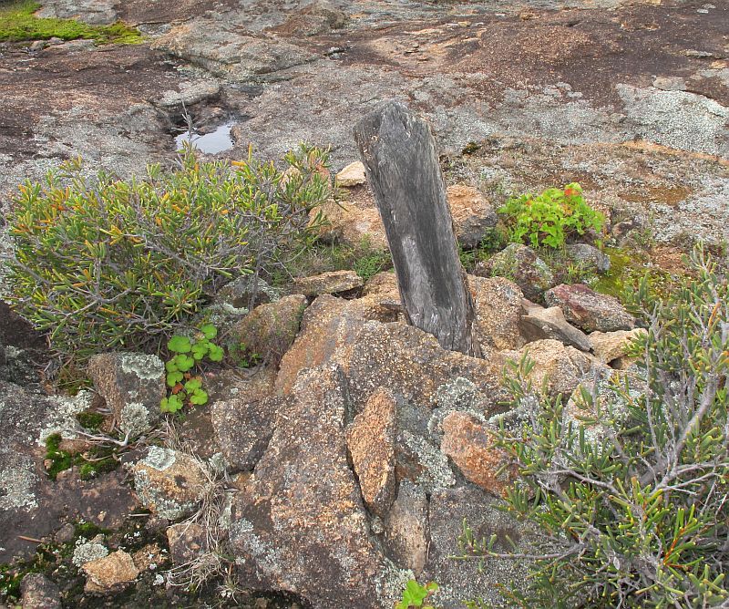
A very old survey marker on a remote rocky outcrop NE of Esperance. Made from hard mallee timber, plus being on a granite outcrop with little other vegetation, helped preserve it from decay and bushfires.

Date: 20/02/2014 17:41:32
From: diddly-squat
ID: 492346
Subject: re: Ethel the Aardvark goes Quantity Surveying
every now and then you’ll see something like this on a footpath, or similar. This is a survey marker.

Date: 20/02/2014 17:43:24
From: diddly-squat
ID: 492348
Subject: re: Ethel the Aardvark goes Quantity Surveying
Here is how a traverse works
Date: 20/02/2014 17:44:43
From: Ian
ID: 492349
Subject: re: Ethel the Aardvark goes Quantity Surveying
Surveying just ain’t what it used to be.
————————
2 of my family stuck their structures a couple of hundred mm into the neighbor’ s place thanks to surveyors of old.
Date: 20/02/2014 17:47:07
From: PermeateFree
ID: 492350
Subject: re: Ethel the Aardvark goes Quantity Surveying
PermeateFree said:
A very old survey marker on a remote rocky outcrop NE of Esperance. Made from hard mallee timber, plus being on a granite outcrop with little other vegetation, helped preserve it from decay and bushfires.
Try this
http://s276.photobucket.com/user/W_Archer/media/Album%202/MalleeSurveyMarkerNEofEsperance.jpg.htm
Date: 20/02/2014 17:48:09
From: Obviousman
ID: 492351
Subject: re: Ethel the Aardvark goes Quantity Surveying
diddly-squat said:
Obviousman said:
So how do they determine where they are measuring from and measuring to?
there are a series of known or ‘fixed’ points. The position of these points is well defined in all three dimensions.
A surveyor then shoots from the known point to the point (or points) of interest so as to locate it (or them) on the ground.
The surveyor then shoot back from the point of interest to the know point so as to ‘close’ what’s call a ‘traverse’
This way the surveyor can either locate points on the ground from a plan, or survey a point on the ground so as to locate it on a plan.
Ah! That makes sense. What if there are no known points?
Date: 20/02/2014 17:50:34
From: Peak Warming Man
ID: 492352
Subject: re: Ethel the Aardvark goes Quantity Surveying
Obviousman said:
diddly-squat said:
Obviousman said:
So how do they determine where they are measuring from and measuring to?
there are a series of known or ‘fixed’ points. The position of these points is well defined in all three dimensions.
A surveyor then shoots from the known point to the point (or points) of interest so as to locate it (or them) on the ground.
The surveyor then shoot back from the point of interest to the know point so as to ‘close’ what’s call a ‘traverse’
This way the surveyor can either locate points on the ground from a plan, or survey a point on the ground so as to locate it on a plan.
Ah! That makes sense. What if there are no known points?
You make one by getting magnetic north and shooting a star with a sextant. and getting a height above sea level with a barometer.
Date: 20/02/2014 17:52:00
From: Stealth
ID: 492353
Subject: re: Ethel the Aardvark goes Quantity Surveying
You can’t measure distance with a theodolite?
—————-
Of course you can, you just need to use the right metric…
…my desk is 1Th wide and it is about 2.5Th from my office door.
Date: 20/02/2014 17:56:08
From: PermeateFree
ID: 492356
Subject: re: Ethel the Aardvark goes Quantity Surveying
PermeateFree said:
PermeateFree said:
A very old survey marker on a remote rocky outcrop NE of Esperance. Made from hard mallee timber, plus being on a granite outcrop with little other vegetation, helped preserve it from decay and bushfires.
Try this
http://s276.photobucket.com/user/W_Archer/media/Album%202/MalleeSurveyMarkerNEofEsperance.jpg.htm
Photobucket really playing up today. Hopefully this is it.
Date: 20/02/2014 17:56:29
From: Thomo
ID: 492357
Subject: re: Ethel the Aardvark goes Quantity Surveying
Ian said:
Surveying just ain’t what it used to be.
————————
2 of my family stuck their structures a couple of hundred mm into the neighbor’ s place thanks to surveyors of old.
Its actually amazing the number of boundary fences that are within an inch or two of the true boundary.
To end up building a couple of hundred mm into the neighbor’ s property is rare in the extreme and usually involves one of those great experts the “Owner Builder”
Date: 20/02/2014 18:04:50
From: PM 2Ring
ID: 492358
Subject: re: Ethel the Aardvark goes Quantity Surveying
The Rev Dodgson said:
For some historical context on this thread:
http://www.youtube.com/watch?v=eCM2nEBE0RY
Ah. I thought the thread title sounded familiar.
Date: 20/02/2014 18:12:56
From: Ian
ID: 492359
Subject: re: Ethel the Aardvark goes Quantity Surveying
Thomo said:
Ian said:
Surveying just ain’t what it used to be.
————————
2 of my family stuck their structures a couple of hundred mm into the neighbor’ s place thanks to surveyors of old.
Its actually amazing the number of boundary fences that are within an inch or two of the true boundary.
To end up building a couple of hundred mm into the neighbor’ s property is rare in the extreme and usually involves one of those great experts the “Owner Builder”
One of them may have been down to an Owner Builder but the other multi story brick thing was the fault of the “pros”.
Date: 20/02/2014 18:19:32
From: CrazyNeutrino
ID: 492360
Subject: re: Ethel the Aardvark goes Quantity Surveying
Ian said:
Thomo said:
Ian said:
Surveying just ain’t what it used to be.
————————
2 of my family stuck their structures a couple of hundred mm into the neighbor’ s place thanks to surveyors of old.
Its actually amazing the number of boundary fences that are within an inch or two of the true boundary.
To end up building a couple of hundred mm into the neighbor’ s property is rare in the extreme and usually involves one of those great experts the “Owner Builder”
One of them may have been down to an Owner Builder but the other multi story brick thing was the fault of the “pros”.
A piece of Wood?
Date: 20/02/2014 18:44:18
From: Ian
ID: 492368
Subject: re: Ethel the Aardvark goes Quantity Surveying
CrazyNeutrino said:
Ian said:
Thomo said:
Its actually amazing the number of boundary fences that are within an inch or two of the true boundary.
To end up building a couple of hundred mm into the neighbor’ s property is rare in the extreme and usually involves one of those great experts the “Owner Builder”
One of them may have been down to an Owner Builder but the other multi story brick thing was the fault of the “pros”.
A piece of Wood?
How do you tell if the’re made of wood?
Date: 20/02/2014 18:46:03
From: PermeateFree
ID: 492371
Subject: re: Ethel the Aardvark goes Quantity Surveying
CrazyNeutrino said:
Ian said:
Thomo said:
Its actually amazing the number of boundary fences that are within an inch or two of the true boundary.
To end up building a couple of hundred mm into the neighbor’ s property is rare in the extreme and usually involves one of those great experts the “Owner Builder”
One of them may have been down to an Owner Builder but the other multi story brick thing was the fault of the “pros”.
A piece of Wood?
I am beginning to suspect you doubt my marker photo is genuine, so let me explain what happened in the early days.
Surveyed cleared Lines where created through the bush throughout most of WA, as were any prominent landmarks encountered along the way. These early surveyors were from major towns and cities often far away and travelled to these remote locations on horseback, as there were few or no roads, therefore they did not carry much in the way of metal pegs due to the weight factor.
Pegs were carved from the mallee timber and no doubt many were burnt during bushfires, but they had served their purpose in plotting the line. The pegs were cut at the top into a four sided pyramid as can be made out in the photo and some were then blazed with an official stamp.
Stations both big and small were surveyed, along with many landmarks along the access points.
The world out there is a big place, but chances are a surveyor has already been there at some stage.
Date: 20/02/2014 19:12:23
From: mollwollfumble
ID: 492395
Subject: re: Ethel the Aardvark goes Quantity Surveying
Back in 1979 I did a university surveying course.
The theodolite measures angles, including horizontal. The measuring pole measures vertical distance. The tape measure measures distance along the ground.
These days the tape measure is replaced by the laser rangefinder, and differential GPS is often used to get horizontal distances.
So far as I can tell, for vertical distances the combination of theodolite and measuring pole gives the most accurate results.
Date: 20/02/2014 19:17:01
From: captain_spalding
ID: 492396
Subject: re: Ethel the Aardvark goes Quantity Surveying
Would Ethel need any of these instruments for quantity surveying?
Date: 21/02/2014 00:43:26
From: Stealth
ID: 492568
Subject: re: Ethel the Aardvark goes Quantity Surveying
Can’t distance be determined with a theodilite by measuring the angle subtended by the measuring pole?
Date: 21/02/2014 07:59:00
From: The Rev Dodgson
ID: 492586
Subject: re: Ethel the Aardvark goes Quantity Surveying
Stealth said:
Can’t distance be determined with a theodilite by measuring the angle subtended by the measuring pole?
Yes, they can, although the precision is limited over typical surveying distances, and total stations do it automatically now anyway.