Date: 7/03/2015 21:41:35
From: Aquila
ID: 690127
Subject: Marree Man (from chat earlier in da day)
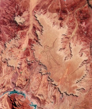
It doesn’t look like a boomerang to me, looks more like a straight stick of some kind and the form is human body with a bird head.
It’s almost Egyptian in styling…
Date: 7/03/2015 21:43:47
From: party_pants
ID: 690128
Subject: re: Marree Man (from chat earlier in da day)
where is Maree?
I’d like to look it up on various maps services.
Date: 7/03/2015 21:43:48
From: Aquila
ID: 690129
Subject: re: Marree Man (from chat earlier in da day)
The figure is 4.2 km tall.
Date: 7/03/2015 21:44:30
From: furious
ID: 690130
Subject: re: Marree Man (from chat earlier in da day)
- It doesn’t look like a boomerang to me
A woomera?
Date: 7/03/2015 21:45:33
From: Aquila
ID: 690132
Subject: re: Marree Man (from chat earlier in da day)
https://en.m.wikipedia.org/wiki/Marree,_South_Australia
Date: 7/03/2015 21:45:37
From: furious
ID: 690133
Subject: re: Marree Man (from chat earlier in da day)
- and the form is human body with a bird head.
Its his hair tied behind his head…
Date: 7/03/2015 21:49:58
From: stumpy_seahorse
ID: 690134
Subject: re: Marree Man (from chat earlier in da day)
party_pants said:
where is Maree?
I’d like to look it up on various maps services.
you can find it on google earth
Date: 7/03/2015 21:51:07
From: party_pants
ID: 690135
Subject: re: Marree Man (from chat earlier in da day)
stumpy_seahorse said:
party_pants said:
where is Maree?
I’d like to look it up on various maps services.
you can find it on google earth
that’s what I intend to do, in the next hour or so.
Date: 7/03/2015 21:52:01
From: Aquila
ID: 690136
Subject: re: Marree Man (from chat earlier in da day)
furious said:
- and the form is human body with a bird head.
Its his hair tied behind his head…
Are you sure?
wait…. what!?
lol

Date: 7/03/2015 21:54:17
From: Witty Rejoinder
ID: 690137
Subject: re: Marree Man (from chat earlier in da day)
Aquila said:
The figure is facing left.
Date: 7/03/2015 21:54:33
From: Aquila
ID: 690138
Subject: re: Marree Man (from chat earlier in da day)
ha! Marree is at the junction of the Oodnadatta track and the Birdsville track
Date: 7/03/2015 21:54:35
From: furious
ID: 690139
Subject: re: Marree Man (from chat earlier in da day)
Date: 7/03/2015 21:56:18
From: party_pants
ID: 690140
Subject: re: Marree Man (from chat earlier in da day)
his tackle is rather indistinct.
Date: 7/03/2015 21:57:27
From: buffy
ID: 690141
Subject: re: Marree Man (from chat earlier in da day)
Things I just read said it’s pretty hard to see on Google earth now. Eroded away. It’s some years since it was done and the dust moves.
Date: 7/03/2015 21:58:37
From: Aquila
ID: 690142
Subject: re: Marree Man (from chat earlier in da day)
furious said:

Ah yes, you’re correct, I just read this
There was initially some question as to whether the figure is holding a throwing stick or a boomerang, but these issues seem to have been resolved following discovery of the plaque and the origin of the plaque quote and likely source photographs of similar nude hunters. The hand which is not throwing has the correct posture in the normal Aboriginal technique for throwing. The initiation scars placed on the chest have also been said to have been placed perfectly. The figure appears to be an amalgam of the body of a man photographed in the distinctive throwing stance and the head of another man wearing a headband and chignon.
Date: 7/03/2015 22:04:27
From: stumpy_seahorse
ID: 690143
Subject: re: Marree Man (from chat earlier in da day)
buffy said:
Things I just read said it’s pretty hard to see on Google earth now. Eroded away. It’s some years since it was done and the dust moves.
yeah i saw it at the end of 1998, pretty impressive work
Date: 7/03/2015 22:10:32
From: stumpy_seahorse
ID: 690144
Subject: re: Marree Man (from chat earlier in da day)
Aquila said:
ha! Marree is at the junction of the Oodnadatta track and the Birdsville track
have a look around where borefield road meets the oodnadatta track from memory, it’s not far from there
Date: 7/03/2015 22:22:57
From: party_pants
ID: 690146
Subject: re: Marree Man (from chat earlier in da day)
Any further idwas where – north, south, est or west of the township of Maree, distance in km
Date: 7/03/2015 22:25:16
From: Speedy
ID: 690148
Subject: re: Marree Man (from chat earlier in da day)
party_pants said:
Any further idwas where – north, south, est or west of the township of Maree, distance in km
29.5300° S, 137.4655° E is supposedly on top of his head. I can’t see anything there.
Date: 7/03/2015 22:25:45
From: sibeen
ID: 690149
Subject: re: Marree Man (from chat earlier in da day)
Zims need 7 off the last over. 2 wickets in hand.
Date: 7/03/2015 22:26:53
From: sibeen
ID: 690150
Subject: re: Marree Man (from chat earlier in da day)
sibeen said:
Zims need 7 off the last over. 2 wickets in hand.
Yeah, yeah…shaddup!
Date: 7/03/2015 22:29:44
From: stumpy_seahorse
ID: 690153
Subject: re: Marree Man (from chat earlier in da day)
party_pants said:
Any further idwas where – north, south, est or west of the township of Maree, distance in km
probably 50km west.we went leigh creek-marree, turned off oodnadatta track, went bush and got there, went further bush and got to the junction with borefield and went down to olympic dam
Date: 7/03/2015 22:31:21
From: JudgeMental
ID: 690156
Subject: re: Marree Man (from chat earlier in da day)
speedy you can see the plough marks. the lat lon you gave look like the chest striations.
Date: 7/03/2015 22:39:59
From: party_pants
ID: 690157
Subject: re: Marree Man (from chat earlier in da day)
Speedy said:
party_pants said:
Any further idwas where – north, south, est or west of the township of Maree, distance in km
29.5300° S, 137.4655° E is supposedly on top of his head. I can’t see anything there.
Can see it on Bing Maps using that latitude and longitude.
Date: 7/03/2015 22:42:47
From: Speedy
ID: 690158
Subject: re: Marree Man (from chat earlier in da day)
JudgeMental said:
speedy you can see the plough marks. the lat lon you gave look like the chest striations.
I just slid the Google Earth time slider thingy back to 2007 and it is quite clear.
Date: 7/03/2015 22:44:01
From: Speedy
ID: 690159
Subject: re: Marree Man (from chat earlier in da day)
Speedy said:
JudgeMental said:
speedy you can see the plough marks. the lat lon you gave look like the chest striations.
I just slid the Google Earth time slider thingy back to 2007 and it is quite clear.
Those GPS co-ordinates point at his chest.
Date: 7/03/2015 22:47:22
From: party_pants
ID: 690160
Subject: re: Marree Man (from chat earlier in da day)
buffy said:
Things I just read said it’s pretty hard to see on Google earth now. Eroded away. It’s some years since it was done and the dust moves.
Obviously a modern fake then.
Date: 7/03/2015 22:48:26
From: furious
ID: 690161
Subject: re: Marree Man (from chat earlier in da day)
- Obviously a modern fake then.
I thought that was well established…
Date: 7/03/2015 22:51:37
From: wookiemeister
ID: 690162
Subject: re: Marree Man (from chat earlier in da day)
I found a lost city of scantily clad women on google maps once
Date: 7/03/2015 22:53:14
From: party_pants
ID: 690166
Subject: re: Marree Man (from chat earlier in da day)
furious said:
- Obviously a modern fake then.
I thought that was well established…
I’m a latecomer to this sage. I only heard about it this afternoon.
Date: 7/03/2015 22:54:30
From: wookiemeister
ID: 690167
Subject: re: Marree Man (from chat earlier in da day)
they’ll find a salt pyramid one day
Date: 7/03/2015 23:00:24
From: furious
ID: 690169
Subject: re: Marree Man (from chat earlier in da day)
- I’m a latecomer to this sage.
I like to think that I am wise but I’m not that wise…
Date: 8/03/2015 09:47:31
From: CrazyNeutrino
ID: 690295
Subject: re: Marree Man (from chat earlier in da day)
what is he pointing at, if you draw a line from his pointing does it lead anywhere significant?
Date: 8/03/2015 10:14:44
From: roughbarked
ID: 690311
Subject: re: Marree Man (from chat earlier in da day)
CrazyNeutrino said:
what is he pointing at, if you draw a line from his pointing does it lead anywhere significant?
At a flock of budgies that flew past on the day.
Date: 9/03/2015 06:02:40
From: mollwollfumble
ID: 690427
Subject: re: Marree Man (from chat earlier in da day)
Anyone see anything about what it’s made from? My first guess would be from a line of stones. In the Nazca lines, stones were removed to expose the white soil beneath, Maree Man is a dark line so it could be that darker stones were trucked in from elsewhere.
Date: 9/03/2015 06:29:03
From: stumpy_seahorse
ID: 690430
Subject: re: Marree Man (from chat earlier in da day)
mollwollfumble said:
Anyone see anything about what it’s made from? My first guess would be from a line of stones. In the Nazca lines, stones were removed to expose the white soil beneath, Maree Man is a dark line so it could be that darker stones were trucked in from elsewhere.
it’s ploughed in the ground, about 30m wide, about a foot deep on each line
Date: 9/03/2015 08:21:22
From: Carmen_Sandiego
ID: 690445
Subject: re: Marree Man (from chat earlier in da day)
Google Maps link:
https://www.google.com/maps/@-29.5300738,137.4608163,259m/data=!3m1!1e3?hl=en-US
Date: 9/03/2015 08:24:13
From: Carmen_Sandiego
ID: 690446
Subject: re: Marree Man (from chat earlier in da day)
Carmen_Sandiego said:
Google Maps link:
https://www.google.com/maps/@-29.5300738,137.4608163,259m/data=!3m1!1e3?hl=en-US
That is the underside of his westward-facing arm, BTW.
Date: 9/03/2015 09:25:49
From: The Rev Dodgson
ID: 690482
Subject: re: Marree Man (from chat earlier in da day)
Carmen_Sandiego said:
Carmen_Sandiego said:
Google Maps link:
https://www.google.com/maps/@-29.5300738,137.4608163,259m/data=!3m1!1e3?hl=en-US
That is the underside of his westward-facing arm, BTW.
Thanks for the link CS. I was unable to find it myself, now I know why.
Date: 10/03/2015 14:02:45
From: mollwollfumble
ID: 691343
Subject: re: Marree Man (from chat earlier in da day)
stumpy_seahorse said:
mollwollfumble said:
Anyone see anything about what it’s made from? My first guess would be from a line of stones. In the Nazca lines, stones were removed to expose the white soil beneath, Maree Man is a dark line so it could be that darker stones were trucked in from elsewhere.
it’s ploughed in the ground, about 30m wide, about a foot deep on each line
Thanks for that, so it’s essentially a bulldozer-built track.
Date: 10/03/2015 14:05:02
From: roughbarked
ID: 691346
Subject: re: Marree Man (from chat earlier in da day)
mollwollfumble said:
stumpy_seahorse said:
mollwollfumble said:
Anyone see anything about what it’s made from? My first guess would be from a line of stones. In the Nazca lines, stones were removed to expose the white soil beneath, Maree Man is a dark line so it could be that darker stones were trucked in from elsewhere.
it’s ploughed in the ground, about 30m wide, about a foot deep on each line
Thanks for that, so it’s essentially a bulldozer-built track.
I did ask what plough but got no answer because well nobody knows but what else looks like a plough but makes deeper ruts? It is a bulldozer towing rippers.
Date: 10/03/2015 14:11:58
From: Michael V
ID: 691358
Subject: re: Marree Man (from chat earlier in da day)
mollwollfumble said:
stumpy_seahorse said:
mollwollfumble said:
Anyone see anything about what it’s made from? My first guess would be from a line of stones. In the Nazca lines, stones were removed to expose the white soil beneath, Maree Man is a dark line so it could be that darker stones were trucked in from elsewhere.
it’s ploughed in the ground, about 30m wide, about a foot deep on each line
Thanks for that, so it’s essentially a bulldozer-built track.
Yes, supposedly.